Chest opened
+${chestReward.xp} XP
Explorer
NOUVEAU ×${chestReward.collectible.quantity}
tapez pour fermer
Chest locked

Open chests in the app

Around Us is built for your phone — chests unlock when you walk, explore and capture nearby places.

Enable Location

We need your location to show you interesting places around you

Discover nearby places

Find interesting locations and hidden gems around you

Precise directions

Get accurate directions and distances to places

Your location is never shared with other users. It's only used when you tap the location button.

Log in to your account

Start exploring — it's free

Trusted by 72,939 travelers worldwide

Continue with Google
Continue with Apple
or

We will send you a code to connect

By continuing, you accept our Terms and Conditions and our Privacy Policy

Check your inbox

We've sent a pincode in your inbox. Please enter the code below.

Fort Zarah
Discussion Reviews Photo
3.2k Popularity

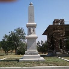
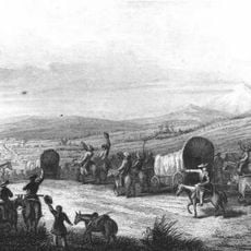
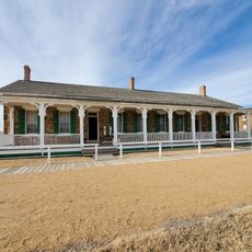
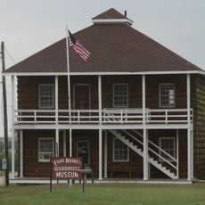
Fort Zarah, Military outpost at Walnut Creek Crossing, Kansas, United States.

Fort Zarah was a military outpost at Walnut Creek Crossing in Kansas, built with stone structures that housed officer quarters, troop barracks, kitchens, and storage areas. The compound was designed as a compact installation to provide protection and supplies at this strategic point along the Santa Fe Trail.

General Samuel Curtis established the fort in 1864 to protect travelers on the Santa Fe Trail during a surge in traffic caused by gold discoveries in Colorado. The installation operated for only five years before closing in 1869, after which its stone and materials were dismantled and moved to Fort Harker.

The location served as a negotiation site in 1866 where leaders from multiple Indigenous nations, including Kiowa, Comanche, Cheyenne, Arapahoe, and Apache, gathered to discuss their futures. This role made it a meeting point of great consequence during a period of rapid change.

The site sits at a river crossing, which helps explain why it was chosen for its location. Visitors can see the flat landscape and open surroundings that made it possible to monitor traffic along the historic trail route.

The fort was named to honor Major H. Zarah Curtis, who was killed during the Baxter Springs Massacre in the Civil War. This personal connection shows how military posts were often named after fallen soldiers.

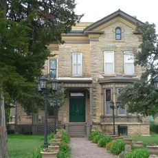
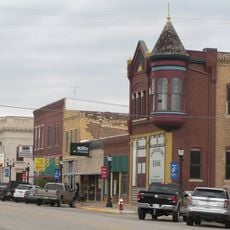
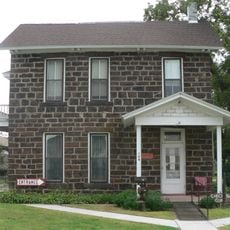
The community of curious travelers

AroundUs brings together thousands of curated places, local tips, and hidden gems, enriched daily by 60,000 contributors worldwide.

Start exploring
Location
GPS coordinates
38.40280,-98.73060
Latest update
December 12, 2025 09:05
Around this place
Wilson Lake
United States of America

Wilson Lake

61.7 km
Basilica of St. Fidelis
United States of America

Basilica of St. Fidelis

62.3 km
Kanopolis State Park
United States of America

Kanopolis State Park

69.7 km
Quivira National Wildlife Refuge
United States of America

Quivira National Wildlife Refuge

31.2 km
Pawnee Rock
United States of America

Pawnee Rock

26.3 km
Fort Harker
United States of America

Fort Harker

60.5 km
Kansas Barbed Wire Museum
United States of America

Kansas Barbed Wire Museum

52.4 km
Wilson State Park
United States of America

Wilson State Park

60.5 km
Great Bend Army Airfield
United States of America

Great Bend Army Airfield

13.3 km
Dream Theater
United States of America

Dream Theater

55.5 km
Kanopolis Drive-in Theatre
United States of America

Kanopolis Drive-in Theatre

60.9 km
Stafford Reformed Presbyterian Church
United States of America

Stafford Reformed Presbyterian Church

50.2 km
Rush County Courthouse
United States of America

Rush County Courthouse

52.5 km
Bridge 650
United States of America

Bridge 650

31.5 km
Farmers National Bank
United States of America

Farmers National Bank

50.4 km
Nagel House
United States of America

Nagel House

7 km
Rice County Courthouse
United States of America

Rice County Courthouse

46.4 km
Stafford First United Methodist Church
United States of America

Stafford First United Methodist Church

50.2 km
Santa Fe Trail
United States of America

Santa Fe Trail

27.3 km
Arthur Larkin House
United States of America

Arthur Larkin House

55.8 km
Ellsworth Downtown Historic District
United States of America

Ellsworth Downtown Historic District

56.8 km
Fort Larned National Historic Site
United States of America

Fort Larned National Historic Site

49.1 km
Perry Hodgden House
United States of America

Perry Hodgden House

56.5 km
Insurance Building
United States of America

Insurance Building

56.7 km
Ft Harker Museum
United States of America

Ft Harker Museum

60.2 km
Spring Creek Tributary Bridge
United States of America

Spring Creek Tributary Bridge

70.5 km
Fort Harker Officers' Quarters
United States of America

Fort Harker Officers' Quarters

60.4 km
Fort Harker Guardhouse
United States of America

Fort Harker Guardhouse

60.2 km
Show the full map
Reviews
Share your experience

No review yet

Discussions
Start a discussion...

No discussion yet

« Fort Zarah - Military outpost at Walnut Creek Crossing, Kansas, United States » is provided by Around Us (aroundus.com). Images and texts are derived from Wikimedia project under a Creative Commons license. You are allowed to copy, distribute, and modify copies of this page, under the conditions set by the license, as long as this note is clearly visible.

Discover hidden gems everywhere you go!

From secret cafés to breathtaking viewpoints, skip the crowded tourist spots and find places that match your style. Our app makes it easy with voice search, smart filtering, route optimization, and insider tips from travelers worldwide. Download now for the complete mobile experience.

Around Us App Screenshot

A unique approach to discovering new places

Le Figaro

All the places worth exploring

France Info

A tailor-made excursion in just a few clicks

20 Minutes

Around Us
Travel Guide & Maps
Download

Send to your phone

QR Code
1

Open the camera app on your mobile.

2

Point at the QR code with your camera. A notification will appear.

3

Tap the notification to open the link.