Enable Location

We need your location to show you interesting places around you

Discover nearby places

Find interesting locations and hidden gems around you

Precise directions

Get accurate directions and distances to places

Your location is never shared with other users. It's only used when you tap the location button.

Lomonosov Ridge

Log in to your account

Start exploring — it's free

Trusted by 68,286 travelers worldwide

Continue with Google
Continue with Apple
or

We will send you a code to connect

By continuing, you accept our Terms and Conditions and our Privacy Policy

Check your inbox

We've sent a pincode in your inbox. Please enter the code below.

Lomonosov Ridge
Discussion Reviews 1 Photos
17.6k Popularity

Lomonosov Ridge, Underwater mountain range in Arctic Ocean

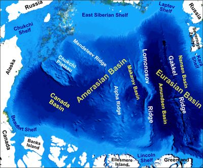
The Lomonosov Ridge is an underwater mountain range running beneath the Arctic Ocean between Siberia and North America. This geological formation rises significantly from the seafloor and extends across a vast distance through the central Arctic waters.

Soviet researchers first discovered this underwater formation during Arctic expeditions in the 1940s. The ridge was named after Mikhail Lomonosov, a prominent Russian scientist and scholar.

Three nations - Russia, Denmark, and Canada - conduct research missions to study the ridge's composition for territorial claims in the Arctic region.

Access to this formation is limited to specialized research vessels equipped with sonar technology operating in Arctic waters. Exploration requires advanced equipment and is restricted to scientific missions.

The formation divides the Arctic Ocean into two separate basins, with its shallowest point lying considerably closer to the surface than surrounding areas. This distinctive feature makes it a focus for marine research and study.

The community of curious travelers

AroundUs brings together thousands of curated places, local tips, and hidden gems, enriched daily by 60,000 contributors worldwide.

Start exploring
Location
undersea landform
GPS coordinates
75.00000,175.00000
Latest update
December 7, 2025 19:24
Around this place
Zapovednik Wrangel Island
Russian Federation

Zapovednik Wrangel Island

442.5 km

Pleistocene Park
Russian Federation

Pleistocene Park

856.9 km
Bilibino Nuclear Power Plant
Russian Federation

Bilibino Nuclear Power Plant

827.2 km
Bolshoy Lyakhovsky Island
Russian Federation

Bolshoy Lyakhovsky Island

1004 km
Jeannette Island
Russian Federation

Jeannette Island

499.1 km
Zhokhov Island
Russian Federation

Zhokhov Island

627.2 km
Herald Island
Russian Federation

Herald Island

501.2 km
Rogers-Post Site
United States of America

Rogers-Post Site

989.2 km
Point Barrow Long Range Radar Site
United States of America

Point Barrow Long Range Radar Site

989.2 km
Stolbovoy Island
Russian Federation

Stolbovoy Island

1144.2 km
United States of America

Ipiutak Site

968.6 km
Monument to Semyon Dezhnev
Russian Federation

Monument to Semyon Dezhnev

1141.9 km
Pegtymel Petroglyphs
Russian Federation

Pegtymel Petroglyphs

603.1 km
Kytalyk National Park
Russian Federation

Kytalyk National Park

988.1 km
Maly Lyakhovsky Island
Russian Federation

Maly Lyakhovsky Island

1010.7 km
Lake Ozhogino
Russian Federation

Lake Ozhogino

1143.5 km
Russian Federation

Routan Islands

606.5 km
Birnirk Site
United States of America

Birnirk Site

988.9 km
Lake Bolshoye Morskoye
Russian Federation

Lake Bolshoye Morskoye

767.8 km
Northeast Science Station
Russian Federation

Northeast Science Station

836.8 km
Iñupiat Heritage Center
United States of America

Iñupiat Heritage Center

987.8 km
Utqiaġvik Church Manse
United States of America

Utqiaġvik Church Manse

987.4 km
Kugururok River
United States of America

Kugururok River

1098.8 km
Мемориальный комплекс «Памятник первым Ревкомовцам» (Анадырь)
Russian Federation

Мемориальный комплекс «Памятник первым Ревкомовцам» (Анадырь)

1146.1 km
Памятник «Авиаторам — первопроходцам и защитникам неба Чукотки» (Угольные Копи)
Russian Federation

Памятник «Авиаторам — первопроходцам и защитникам неба Чукотки» (Угольные Копи)

1145.9 km
Памятник-бюст геологу Ю.А. Билибину (Билибино)
Russian Federation

Памятник-бюст геологу Ю.А. Билибину (Билибино)

828 km
Ванкаремская школа - памятник Челюскинской эпопеи (Ванкарем)
Russian Federation

Ванкаремская школа - памятник Челюскинской эпопеи (Ванкарем)

858.1 km
Show the full map
Reviews
Share your experience

No review yet

Discussions
Start a discussion...

No discussion yet

« Lomonosov Ridge - Underwater mountain range in Arctic Ocean » is provided by Around Us (aroundus.com). Images and texts are derived from Wikimedia project under a Creative Commons license. You are allowed to copy, distribute, and modify copies of this page, under the conditions set by the license, as long as this note is clearly visible.

Discover hidden gems everywhere you go!

From secret cafés to breathtaking viewpoints, skip the crowded tourist spots and find places that match your style. Our app makes it easy with voice search, smart filtering, route optimization, and insider tips from travelers worldwide. Download now for the complete mobile experience.

Around Us App Screenshot

A unique approach to discovering new places

Le Figaro

All the places worth exploring

France Info

A tailor-made excursion in just a few clicks

20 Minutes

Around Us
Travel Guide & Maps
Download

Send to your phone

QR Code
1

Open the camera app on your mobile.

2

Point at the QR code with your camera. A notification will appear.

3

Tap the notification to open the link.