Barnes Ice Cap, Ice cap in Baffin Island, Canada
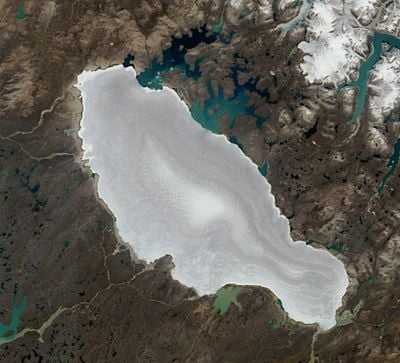
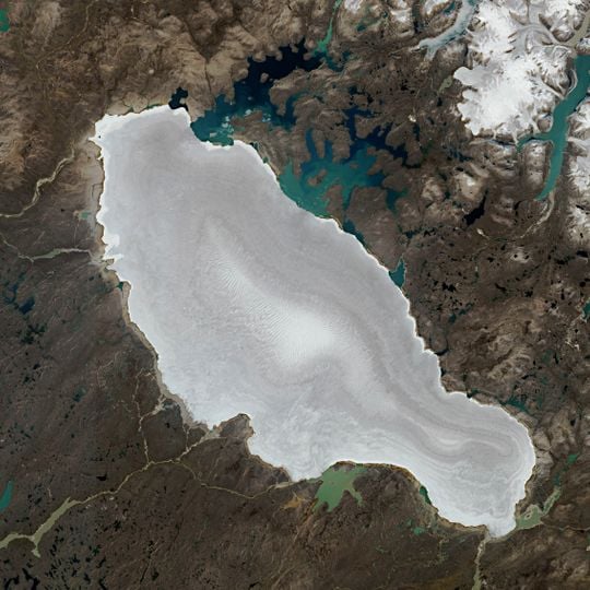
The Barnes Ice Cap is an ice cap covering close to 6,000 km2 in the Baffin Mountains of central Baffin Island, Nunavut. Seen from above, it forms a roughly oval expanse of white and pale grey ice with a lobed edge, its surface ridged in fine concentric bands that rise into a low central dome. At its southeastern end lies Generator Lake, and along the lower right margin the ice narrows into a long tapering tongue.
The ice cap formed roughly 20,000 years ago as a remnant of the Laurentide Ice Sheet that blanketed much of North America during the last glacial period. It has continued to transform as climate conditions shifted over millennia.
The ice cap's name comes from the Barnes family, though the sources do not record who named it. A more concrete story belongs to the ice itself: in 1995 a team from Laramie, Wyoming, made the first bicycle traverse of the cap, sponsored by the Wyoming Alpine Club, with riders Mike and Dan Moe, Sharon Kava and Brad Humphrey. They left their bikes and sleds at 70°31′43″N 73°18′42″W on 22 August 1995; geologist Kurt Refsnider found them by chance in 2009.
Access to this remote ice cap requires specialized equipment and expert guides due to extreme Arctic conditions. Visitors should prepare for powerful winds, severe cold, and intense sun exposure at high altitude.
In 1995 a team from Laramie, Wyoming, made the first bicycle traverse of the ice cap, then left their bikes and sleds on the ice at 70°31′43″N 73°18′42″W on 22 August to cross the boulder fields toward Baffin Bay. Geologist Kurt Refsnider found the abandoned bikes by chance in 2009.
The community of curious travelers
AroundUs brings together thousands of curated places, local tips, and hidden gems, enriched daily by 92,700 contributors worldwide.