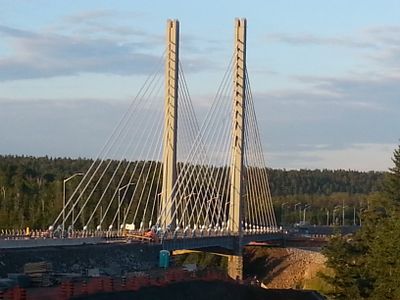
Nipigon River Bridge, Cable-stayed bridge in Nipigon, Canada.
The Nipigon River Bridge is a cable-stayed structure with two parallel traffic lanes spanning two main sections of 126 meters each. Two slender concrete towers hold the steel cables that support the roadway deck, while pedestrian walkways run beneath the driving surface.
Construction of this modern crossing began in 2013, opening to traffic in 2015 to replace two earlier bridges at this location. A serious structural failure occurred just months after opening, leading to a complete closure and repair in 2016.
The route takes its name from the river, which in turn draws its name from the Anishinaabe language meaning "deep water". All Trans-Canada traffic between east and west passes through this structure because there is no alternative route here.
A viewing platform on the north shore offers direct sight of both towers and the cable arrangement from below. Foot access is best during daylight when the traffic on the roadway above is clearly visible.
During the incident in January 2016, the deck lifted by about 60 centimeters on one side, making passage completely impossible. Engineers had to redesign the bearing joint entirely to prevent such damage from happening again.
The community of curious travelers
AroundUs brings together thousands of curated places, local tips, and hidden gems, enriched daily by 60,000 contributors worldwide.