Enable Location

We need your location to show you interesting places around you

Discover nearby places

Find interesting locations and hidden gems around you

Precise directions

Get accurate directions and distances to places

Your location is never shared with other users. It's only used when you tap the location button.

Kisangani

Log in to your account

Start exploring — it's free

Trusted by 63,147 travelers worldwide

Continue with Google
Continue with Apple
or

We will send you a code to connect

By continuing, you accept our Terms and Conditions and our Privacy Policy

Check your inbox

We've sent a pincode in your inbox. Please enter the code below.

Kisangani
Discussion Reviews 4 Photos
60.7k Popularity

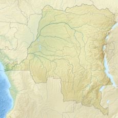
Kisangani, Port city in Tshopo Province, Democratic Republic of the Congo

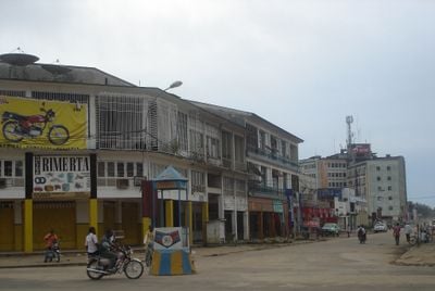
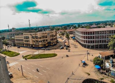
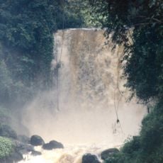
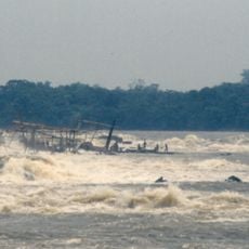
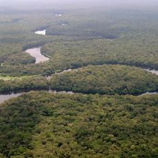
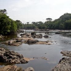
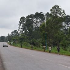
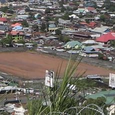
Kisangani is a port city along the Congo River in Tshopo Province, Democratic Republic of the Congo, and stretches along the riverbank where boats end their journey upstream. The city sits below the Boyoma Falls, which prevent further river navigation, and its port facilities connect it to communities downstream while roads lead into the dense inland forest.

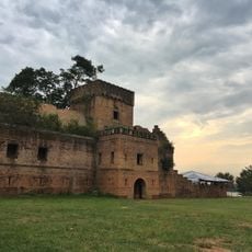
A European explorer established a trading post at the falls in 1883, marking the beginning of permanent settlement at this location. The post grew into a commercial hub that moved goods between the upper river and areas downstream, and administrators later changed the name of the place to honor local languages.

The university hosts thousands of students in buildings along wide avenues and contributes to the academic life of the city. Several faculties offer degrees in medicine, law, and other fields, while students from across the northeastern region come to the city to begin their studies.

The airport sits outside the city center and provides connections to other parts of the country as well as some international destinations. Hotels near the airport and in the downtown area offer accommodations for travelers, while local transport helps move between neighborhoods.

The current name comes from the Swahili language and means city on the island, a translation of the older name Boyoma that reflects the geographic location along the river. This name change occurred in 1966 and reflects efforts to replace colonial designations with terms from local languages.

The community of curious travelers

AroundUs brings together thousands of curated places, local tips, and hidden gems, enriched daily by 60,000 contributors worldwide.

Start exploring
Location
Elevation above the sea
447 m
GPS coordinates
0.51840,25.20573
Latest update
December 13, 2025 19:12
Around this place
Mount Nyiragongo
Congo, Democratic Republic of the

Mount Nyiragongo

504.2 km
Virunga National Park
Congo, Democratic Republic of the

Virunga National Park

491.3 km
Boyoma Falls
Congo, Democratic Republic of the

Boyoma Falls

2.9 km
Volcanoes National Park
Rwanda

Volcanoes National Park

525.9 km
Nyamuragira
Congo, Democratic Republic of the

Nyamuragira

494.1 km
Mount Karisimbi
Rwanda

Mount Karisimbi

523.5 km
Salonga National Park
Congo, Democratic Republic of the

Salonga National Park

451.4 km
Okapi Wildlife Reserve
Congo, Democratic Republic of the

Okapi Wildlife Reserve

402 km
Mount Bisoke
Rwanda

Mount Bisoke

524.7 km
Kahuzi-Biéga National Park
Congo, Democratic Republic of the

Kahuzi-Biéga National Park

421 km
Maiko National Park
Congo, Democratic Republic of the

Maiko National Park

282 km
Mount Mikeno
Congo, Democratic Republic of the

Mount Mikeno

518.4 km
Margherita Peak
Uganda

Margherita Peak

519.7 km
Our Lady of Peace Cathedral, Bukavu
Congo, Democratic Republic of the

Our Lady of Peace Cathedral, Bukavu

527.6 km
Api Elephant Domestication Center
Congo, Democratic Republic of the

Api Elephant Domestication Center

355.4 km
Umuganda Stadium
Rwanda

Umuganda Stadium

513.4 km
Stade Lumumba
Congo, Democratic Republic of the

Stade Lumumba

2.2 km
Mount Luigi di Savoia
Uganda

Mount Luigi di Savoia

521.1 km
Our Lady of the Rosary Cathedral, Kisangani
Congo, Democratic Republic of the

Our Lady of the Rosary Cathedral, Kisangani

2.4 km
Ruwenzori
Congo, Democratic Republic of the

Ruwenzori

516.9 km
Stade de Virunga
Congo, Democratic Republic of the

Stade de Virunga

510 km
Domaine de chasse de Bili-Uere
Congo, Democratic Republic of the

Domaine de chasse de Bili-Uere

447.5 km
Rubi Tele Hunting Reserve
Congo, Democratic Republic of the

Rubi Tele Hunting Reserve

218.8 km
Kirotshe
Congo, Democratic Republic of the

Kirotshe

473.4 km
Domaine de chasse de Maika-Penge
Congo, Democratic Republic of the

Domaine de chasse de Maika-Penge

430.4 km
Dungu Castle
Congo, Democratic Republic of the

Dungu Castle

508.1 km
Mémorial du génocide à Gisenyi
Rwanda

Mémorial du génocide à Gisenyi

513.5 km
Kisangani (teritoryo)
Congo, Democratic Republic of the

Kisangani (teritoryo)

4.2 km
Show the full map
Reviews
Share your experience

No review yet

Discussions
Start a discussion...

No discussion yet

« Kisangani - Port city in Tshopo Province, Democratic Republic of the Congo » is provided by Around Us (aroundus.com). Images and texts are derived from Wikimedia project under a Creative Commons license. You are allowed to copy, distribute, and modify copies of this page, under the conditions set by the license, as long as this note is clearly visible.

Discover hidden gems everywhere you go!

From secret cafés to breathtaking viewpoints, skip the crowded tourist spots and find places that match your style. Our app makes it easy with voice search, smart filtering, route optimization, and insider tips from travelers worldwide. Download now for the complete mobile experience.

Around Us App Screenshot

A unique approach to discovering new places

Le Figaro

All the places worth exploring

France Info

A tailor-made excursion in just a few clicks

20 Minutes

Around Us
Travel Guide & Maps
Download

Send to your phone

QR Code
1

Open the camera app on your mobile.

2

Point at the QR code with your camera. A notification will appear.

3

Tap the notification to open the link.