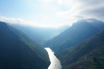
Nho Quế River, River in Ha Giang Province, Vietnam
The Nho Que River is a river in Ha Giang Province in northern Vietnam, cutting through steep limestone mountains and forming deep gorges along its course. Part of its length marks the border between Vietnam and China.
For centuries, this river served as a trade route between Vietnam and China, allowing goods to move through terrain that was otherwise nearly impossible to cross. The route helped shape the mountain communities that grew up along its banks.
Along the banks, local communities use the water for washing, fishing, and daily tasks, with traditional methods still practiced today. Travelers on the water can watch these routines from the boat as they pass through remote stretches of the river.
The river is easiest to reach via the Ma Pi Leng Pass, where boat trips depart toward remote villages along the banks. For some of those villages, the boat is the only practical way in.
The stretch of the river known as Tu San is said to be one of the deepest limestone gorges in Southeast Asia, with walls that rise straight up from the water on both sides. From the boat, the strip of sky visible above is surprisingly narrow.
The community of curious travelers
AroundUs brings together thousands of curated places, local tips, and hidden gems, enriched daily by 60,000 contributors worldwide.