Geopark Mecklenburgische Eiszeitlandschaft, Geological park in southeastern Mecklenburg-Western Pomerania, Germany.
The geopark is a natural area shaped by melting ice masses, featuring hills, lakes, and deep valleys created by glacial retreat. The region spans hundreds of kilometers and displays the visible marks that glaciers left on the land.
The area formed thousands of years ago when massive ice sheets melted and retreated, leaving behind lakes and hills scattered across the landscape. Scientists recognized these natural formations as important records of how glaciers shaped northern regions.
The Müritzeum in Waren serves as the park's action centre, supporting the geopark with special exhibitions on specific projects. The geopark also opens up archaeological, ecological, historical and cultural sites alongside its geological features. Its sponsor is the Geowissenschaftlicher Verein Neubrandenburg, which developed the park concept with the state geological service.
The geopark covers about 4,880 km², roughly a fifth of Mecklenburg-Vorpommern, reaching from Demmin to Feldberg and from Teterow to Pasewalk. The Müritzeum in Waren serves as the park's action centre, a useful first stop for orientation before heading into the Mecklenburg Lake District, Mecklenburg Switzerland or the Feldberger Seenlandschaft.
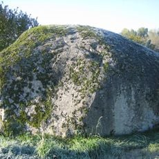
A massive single boulder called the Great Stone near Altentreptow demonstrates the incredible force with which glaciers could transport rock fragments. This stone was carried from far away and stands as visible evidence of these ancient ice movements.
The community of curious travelers
AroundUs brings together thousands of curated places, local tips, and hidden gems, enriched daily by 95,040 contributors worldwide.