Château Beaufort, Medieval castle ruins in Beaufort, France
Château Beaufort is a medieval fortified castle positioned on a rocky headland overlooking the Loire River. The remains show walls and defensive features from multiple construction periods, including archer openings and gun placements adapted from different military eras.
The fortress was built in the 13th century and later modified during the 15th and 16th centuries to adapt to new military technologies. These changes reveal how warfare and defense strategies evolved in France over time.
The castle reflects how French feudal lords used fortified positions to control and defend their territories along the Loire valley. Visitors walking through the ruins can sense how crucial this location was for regional authority and protection.
The site is best reached on foot, as the paths to the ruins are steep and rocky. Wear sturdy shoes and take care in exposed areas where walls are uneven or partially collapsed.
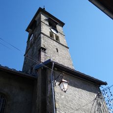
A distinctive horseshoe-shaped tower added in the 16th century by Antoine de la Tour stands in the southwestern corner and gives the castle its recognizable profile. This tower remains visible from many angles across the landscape and serves as the landmark people use to identify the site.
Location: Beaufort
GPS coordinates: 45.72750,6.56167
Latest update: December 9, 2025 12:24
Roselend Dam
6.5 km
Barrage de la Gittaz
6.8 km
Mount Bisanne
4.9 km
Église Saint-Jacques-d'Assyrie de Hauteluce
3.1 km
Église Saint-Maxime-de-Riez de Beaufort
1.5 km
Chard du Beurre
4.8 km
Château de la Grande-Salle
1.3 km
Mont Rond
7.1 km
Réserve naturelle régionale de la tourbière des Saisies - Beaufortain - Val d'Arly
6 km
Lachat
7.1 km
Croix de Coste
5.9 km
Mont Clocher
5.4 km
Mont Mirantin
6.9 km
Défilé d'Entreroches
2.5 km
La Legette
3.3 km
Chaire à prêcher à Beaufort
1.5 km
Réserve naturelle régionale de la tourbière des Saisies
4.4 km
Chapelle Notre-Dame de Belleville
6.9 km
Lac de Roselend
7.1 km
Église Saint-Pierre-aux-Liens de Cohennoz
7.1 km
Église Saint-Jean-Baptiste d'Arêches
4.6 km
Église Saint-Pierre de Villard-sur-Doron
2.6 km
Torrent de la Gittaz
5.2 km
Scenic viewpoint
6.7 km
Chapelle Saint-Jacques de Boudin
5 km
Chapelle Notre-Dame de Haute Lumière
4.1 km
Roche Parstire
6.5 km
Point de vue sur Lac de Roselend
6.7 kmVisited this place? Tap the stars to rate it and share your experience / photos with the community! Try now! You can cancel it anytime.
Discover hidden gems everywhere you go!
From secret cafés to breathtaking viewpoints, skip the crowded tourist spots and find places that match your style. Our app makes it easy with voice search, smart filtering, route optimization, and insider tips from travelers worldwide. Download now for the complete mobile experience.
A unique approach to discovering new places❞
— Le Figaro
All the places worth exploring❞
— France Info
A tailor-made excursion in just a few clicks❞
— 20 Minutes