Chest opened
+${chestReward.xp} XP
Explorer
NOUVEAU ×${chestReward.collectible.quantity}
tapez pour fermer

See the monuments around you in AR Open chests in the app

Around Us is built for your phone — point your camera at the streets and discover the monuments and places around you in augmented reality. Around Us is built for your phone — chests unlock when you walk, explore and capture nearby places.

•

Enable Location

We need your location to show you interesting places around you

Discover nearby places

Find interesting locations and hidden gems around you

Precise directions

Get accurate directions and distances to places

Your location is never shared with other users. It's only used when you tap the location button.

Chamera Dam

Log in to your account

Start exploring — it's free

Trusted by 92,684 travelers worldwide

Continue with Google
Continue with Apple
or

We will send you a code to connect

By continuing, you accept our Terms and Conditions and our Privacy Policy

Check your inbox

We've sent a pincode in your inbox. Please enter the code below.

Chamera Dam

Chamera Dam, Hydroelectric dam in Chamba district, India

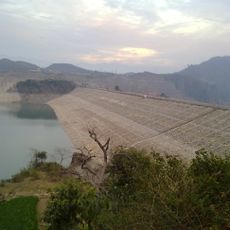
Chamera Dam is a hydroelectric structure across the Ravi River in Chamba district, creating a large reservoir that fills the valley. The installation features multiple powerhouses designed to harness water flow and generate electricity for the region.

Construction of the Chamera Dam began in 1984 on the Ravi River in Chamba district. The first powerhouse was completed in 1994 with three 180 MW Francis turbines, followed by a 300 MW run-of-the-river plant in 2003 and a 231 MW third stage in 2012, for 1,071 MW in total. NHPC Limited owns and operates all three plants.

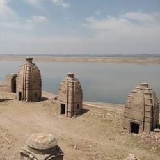
The reservoir, Chamera Lake, largely lies in the Salooni sub-division of Chamba district. Its water level rises between April and June and falls back to 747 m, and the lake holds little aquatic life, so boating, rowing, canoeing and kayaking take place on it. Daytime temperatures near the dam reach 35 °C but drop to 18–20 °C at night.

The dam lies 50 km northeast of Pathankot in the Pir Panjal range, near Dalhousie in Chamba district. The reservoir surface moves between 747 m and 763 m through the year, with the highest water levels from April to June. The minimum level for the power plant to operate is 747 m.

The first phase's powerhouse is a cavern plant reached by a 6.4 km headrace tunnel 9.5 m in diameter; water returns to the Ravi through a 2.4 km tailrace tunnel below the Sewa confluence. The Ranjit Sagar Dam lies 20 km downstream.

The community of curious travelers

AroundUs brings together thousands of curated places, local tips, and hidden gems, enriched daily by 92,684 contributors worldwide.

Start exploring
Location
GPS coordinates
32.59722,75.98583
Latest update
October 25, 2026 08:57
Reviews
Share your experience

No review yet

Discussions
Start a discussion...

No discussion yet

« Chamera Dam - Hydroelectric dam in Chamba district, India » is provided by Around Us (aroundus.com). Images and texts are derived from Wikimedia project under a Creative Commons license. You are allowed to copy, distribute, and modify copies of this page, under the conditions set by the license, as long as this note is clearly visible.

Discover hidden gems everywhere you go!

From secret cafés to breathtaking viewpoints, skip the crowded tourist spots and find places that match your style. Our app makes it easy with voice search, smart filtering, route optimization, and insider tips from travelers worldwide. Download now for the complete mobile experience.

Around Us App Screenshot
❝

A unique approach to discovering new places❞

— Le Figaro

❝

All the places worth exploring❞

— France Info

❝

A tailor-made excursion in just a few clicks❞

— 20 Minutes

Around Us
Travel Guide & Maps
Download

Send to your phone

QR Code
1

Open the camera app on your mobile.

2

Point at the QR code with your camera. A notification will appear.

3

Tap the notification to open the link.