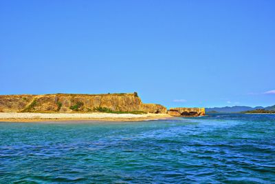
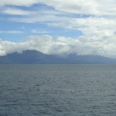
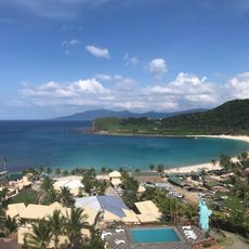
Rona Island, Island destination in Santa Ana, Philippines
Rona Island is an islet in Santa Ana featuring white sand beaches alongside steep rock formations that shape its shoreline. The coastal landscape combines sandy stretches with rugged rocky outcrops along the water's edge.
The island developed as a shelter for fishermen during rough seas and became valued for its access to productive fishing waters. Its role as a working place shaped how people depended on it over time.
Local fishermen practice traditional casting and seasonal fishing methods that form part of everyday life on and around the island. The way people work these waters reflects a long-standing relationship with the sea.
Access to the island depends on weather and sea conditions, which can affect boat departures from the mainland. It is helpful to speak with local boatmen who know when conditions are most favorable for travel.
Natural pools form in volcanic rock formations during high tide, creating clear water basins that visitors can explore. These rock pools change with the tide and offer spontaneous swimming spots in the rock landscape.
Location: Santa Ana
Address: Crocodile Island, Santa Ana, Philippines
GPS coordinates: 18.52582,122.15786
Latest update: December 9, 2025 20:29
Smith Volcano
115.6 km
Callao Cave
98.2 km
Patapat Viaduct
133.4 km
Cagua Volcano
34.1 km
Camiguin de Babuyanes
46.5 km
Babuyan Claro
113.3 km
Basilica of Our Lady of Piat
109.1 km
Buntun Bridge
112.9 km
Tuguegarao Cathedral
111.2 km
Cape Engaño Lighthouse
6.4 km
Magapit Suspension Bridge
68.2 km
Peñablanca Protected Landscape and Seascape
102 km
Lal-lo Church
63.8 km
Malaueg Church
114.6 km
Kabigan Falls
136.7 km
Magapit Protected Landscape
63.5 km
Kalbario-Patapat Natural Park
131.3 km
Hannah's Beach Resort
137.7 km
Phare de Linao Point
61.5 km
Cape Engaño Lighthouse historical marker
6.4 km
Chapel of San Jacinto historical marker
111.1 km
The Landing Site of the USS Stingray historical marker
140 km
St. Paul University Philippines historical marker
111.1 km
The Cathedral of Tuguegarao historical marker
111.2 km
Lalloc–Tocolana historical marker
63.8 km
Lalloc–Nueva Segovia historical marker
63.8 km
Church of Iguig historical marker
97.2 km
Church of Camalaniugan historical marker
58.3 kmVisited this place? Tap the stars to rate it and share your experience / photos with the community! Try now! You can cancel it anytime.
Discover hidden gems everywhere you go!
From secret cafés to breathtaking viewpoints, skip the crowded tourist spots and find places that match your style. Our app makes it easy with voice search, smart filtering, route optimization, and insider tips from travelers worldwide. Download now for the complete mobile experience.
A unique approach to discovering new places❞
— Le Figaro
All the places worth exploring❞
— France Info
A tailor-made excursion in just a few clicks❞
— 20 Minutes