Sunduki Range

Log in to your account

AroundUs is a community-driven map of interesting places, built by curious explorers like you. It grows with every review, story, and photo you share.
Connect to save your favorite spots, contribute locations, and create personalized routes.
Continue with Google
Continue with Apple
Continue with X
Continue with Facebook
Continue with email
By continuing, you accept our Terms and Conditions and our Privacy Policy
Create an account
Add to collection
Map
Suggest a change
Share

Sunduki Range, Natural monument and open-air museum in Khakassia, Russia

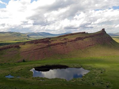
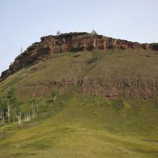
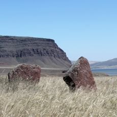
Sunduki Range is a natural monument and open-air museum spread across two districts, with five red sandstone mountains that feature distinctive steep eastern faces. Each peak rises from a gently rolling landscape, with the largest peaks reaching notable heights above the surrounding terrain.

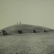
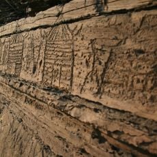
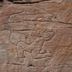
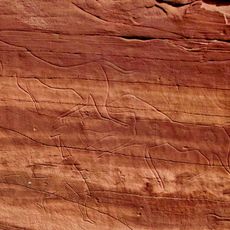
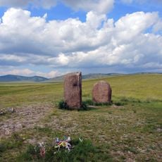
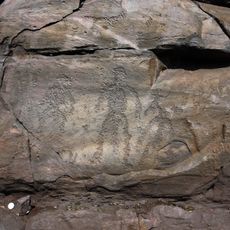
The mountains bear evidence of habitation spanning over 2000 years, beginning with the Tagar culture whose petroglyphs remain visible on the rock faces. Ancient inhabitants engineered irrigation systems and constructed fortified settlements to support agriculture and defense in this region.

Ancient rock carvings scattered across the peaks reveal how communities used this place as a spiritual and territorial marker over millennia. The petroglyphs suggest these mountains held meaning beyond their physical presence in the landscape.

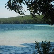
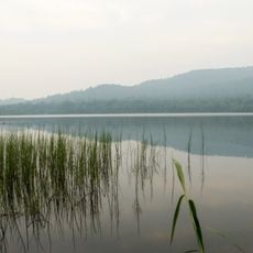
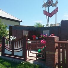
Access to the range comes through dirt tracks that wind through the landscape, making it walkable for visitors of varying abilities. Nearby Lake Bele offers camping facilities where travelers can stay while exploring the peaks over multiple days.

The name Sunduki comes from distinctive cube-shaped rock blocks that resemble storage chests, most notably visible on the northernmost peak. These unusual stone formations gave the entire range its memorable name and remain one of the most distinctive features when walking through the site.

Location: Khakassia

Elevation above the sea: 557 m

Website: http://sunduki19.ru

GPS coordinates: 54.67929,89.70826

Latest update: December 8, 2025 19:44

Photos
Around this place
Kuznetsk Alatau
Russian Federation

Kuznetsk Alatau

86.9 km
Tuim sinkhole
Russian Federation

Tuim sinkhole

41.6 km
Kuznetsk Alatau Nature Reserve
Russian Federation

Kuznetsk Alatau Nature Reserve

108.4 km
Big Salabyk mound
Russian Federation

Big Salabyk mound

111.5 km
Ingol
Russian Federation

Ingol

110.2 km
Ivanovskie ozyora
Russian Federation

Ivanovskie ozyora

68.8 km
Boyarskaya Pisanitsa
Russian Federation

Boyarskaya Pisanitsa

105 km
Sulek petroglyphs
Russian Federation

Sulek petroglyphs

33.2 km
Orthodox cathedral of the Transfiguration of Christ in Abakan
Russian Federation

Orthodox cathedral of the Transfiguration of Christ in Abakan

153 km
Russian Federation

Itat Formation

118.1 km
Chebaki fortress
Russian Federation

Chebaki fortress

30 km
Музейно-выставочный центр города Назарово
Russian Federation

Музейно-выставочный центр города Назарово

155.4 km
Dikoye Lake
Russian Federation

Dikoye Lake

76 km
Mikhail Lermontov Russian Dramatic Theatre
Russian Federation

Mikhail Lermontov Russian Dramatic Theatre

155.5 km
Beryozovo Reservoir
Russian Federation

Beryozovo Reservoir

108.2 km
Holy Trinity Cathedral
Russian Federation

Holy Trinity Cathedral

101.7 km
Центр культуры и народного творчества (Хакасия)
Russian Federation

Центр культуры и народного творчества (Хакасия)

155.4 km
Tsingol
Russian Federation

Tsingol

83.3 km
Saints Peter and Paul сhurche
Russian Federation

Saints Peter and Paul сhurche

72.1 km
Oshkol' petroglyphs
Russian Federation

Oshkol' petroglyphs

21.6 km
Eternal Glory Monument, Ust-Abakan
Russian Federation

Eternal Glory Monument, Ust-Abakan

144.6 km
Памятник «Воинская Слава» (Абакан)
Russian Federation

Памятник «Воинская Слава» (Абакан)

154.8 km
Ivanitsky Estate, Chebaki
Russian Federation

Ivanitsky Estate, Chebaki

34.5 km
Братская могила Советских воинов, умерших от ран в госпиталях в годы Великой Отечественной войны (Абакан)
Russian Federation

Братская могила Советских воинов, умерших от ран в госпиталях в годы Великой Отечественной войны (Абакан)

154.2 km
Памятник воинам-землякам, погибшим в годы Великой Отечественной войны (Соленоозёрное)
Russian Federation

Памятник воинам-землякам, погибшим в годы Великой Отечественной войны (Соленоозёрное)

12.1 km
Менгиры «Салбыкские ворота» (Вершино-Биджа)
Russian Federation

Менгиры «Салбыкские ворота» (Вершино-Биджа)

110.7 km
Sunduki Petroglyphs
Russian Federation

Sunduki Petroglyphs

3.6 km
Fortress Oglakhty
Russian Federation

Fortress Oglakhty

137.4 km
Show the full map
Reviews

Visited this place? Tap the stars to rate it and share your experience / photos with the community! Try now! You can cancel it anytime.

« Sunduki Range - Natural monument and open-air museum in Khakassia, Russia » is provided by Around Us (aroundus.com). Images and texts are derived from Wikimedia project under a Creative Commons license. You are allowed to copy, distribute, and modify copies of this page, under the conditions set by the license, as long as this note is clearly visible.

Discover hidden gems everywhere you go!

From secret cafés to breathtaking viewpoints, skip the crowded tourist spots and find places that match your style. Our app makes it easy with voice search, smart filtering, route optimization, and insider tips from travelers worldwide. Download now for the complete mobile experience.

Around Us App Screenshot

A unique approach to discovering new places

Le Figaro

All the places worth exploring

France Info

A tailor-made excursion in just a few clicks

20 Minutes