Brockway Mountain Drive

Log in to your account

AroundUs is a community-driven map of interesting places, built by curious explorers like you. It grows with every review, story, and photo you share.
Connect to save your favorite spots, contribute locations, and create personalized routes.
Continue with Google
Continue with Apple
Continue with X
Continue with Facebook
Continue with email
By continuing, you accept our Terms and Conditions and our Privacy Policy
Create an account
Add to collection
Map
Suggest a change
Share

Brockway Mountain Drive, Scenic mountain road in Keweenaw County, US

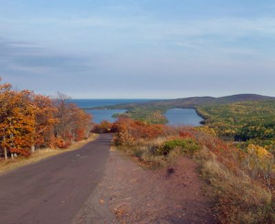
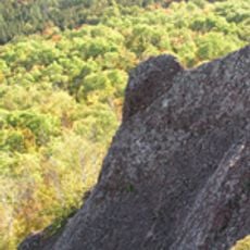
Brockway Mountain Drive is a mountain road in Keweenaw County that stretches roughly 8.8 miles along a ridgeline. The route rises to about 1,320 feet and features multiple pull-off points where you can stop and look out at Lake Superior and the surrounding landscape.

The road was built in 1933 during the Great Depression when copper mining had declined and workers needed employment. This construction project helped provide jobs for people in the area during difficult economic times.

The road is named after an early settler and serves as a gathering place where visitors can pause to take in the expansive views. People stop here to share moments with family and friends while overlooking the water and forests below.

The road is drivable by car with multiple parking areas at lookout points for safe stopping. Plan time to enjoy views from different elevations and to make several stops along the ridge to take in the scenery.

In spring, migrating hawks use this ridge as a landmark while crossing the lake on their journey. Hundreds of plant species grow around the area, changing the landscape appearance with the seasons.

Location: Keweenaw County

GPS coordinates: 47.46423,-87.96911

Latest update: December 6, 2025 16:03

Photos
Michigan natural and historic sites

Michigan holds a wide array of natural and historical sites across its two peninsulas. The shoreline runs for hundreds of miles along the Great Lakes, showing sand beaches, rocky cliffs, and dune formations. In the north, dense forests, waterfalls, and rock formations shaped by erosion dominate the...

Around this place
Fort Wilkins Historic State Park
United States of America

Fort Wilkins Historic State Park

7.5 km
Estivant Pines
United States of America

Estivant Pines

7.2 km
SS S.R. Kirby
United States of America

SS S.R. Kirby

21.9 km
Copper Harbor Light
United States of America

Copper Harbor Light

8.3 km
SS Hudson
United States of America

SS Hudson

21.7 km
Eagle Harbor Light
United States of America

Eagle Harbor Light

14.3 km
Eagle River Timber Bridge
United States of America

Eagle River Timber Bridge

25.4 km
Gull Rock Light Station
United States of America

Gull Rock Light Station

23.6 km
Keweenaw Mountain Lodge and Golf Course Complex
United States of America

Keweenaw Mountain Lodge and Golf Course Complex

4.7 km
Eagle River Light
United States of America

Eagle River Light

25.4 km
Mendota Light
United States of America

Mendota Light

10 km
Central Mine Historic District
United States of America

Central Mine Historic District

18.5 km
Church of the Assumption
United States of America

Church of the Assumption

24.6 km
Eagle Harbor Schoolhouse
United States of America

Eagle Harbor Schoolhouse

14.6 km
Eagle Harbor Coast Guard Station Boathouse
United States of America

Eagle Harbor Coast Guard Station Boathouse

13.6 km
Lake Shore Drive Bridge
United States of America

Lake Shore Drive Bridge

25.3 km
US 41–Fanny Hooe Creek Bridge
United States of America

US 41–Fanny Hooe Creek Bridge

7.3 km
Central Mine Methodist Church
United States of America

Central Mine Methodist Church

18.8 km
Holy Redeemer Church
United States of America

Holy Redeemer Church

14.8 km
M-26–Silver River Culvert
United States of America

M-26–Silver River Culvert

7.8 km
M-26–Cedar Creek Culvert
United States of America

M-26–Cedar Creek Culvert

13.6 km
Klipfel
United States of America

Klipfel

891 m
Eagle River Historic District
United States of America

Eagle River Historic District

25.3 km
Keweenaw County Courthouse
United States of America

Keweenaw County Courthouse

25.1 km
Lake Shore Drive Bridge Historical Marker
United States of America

Lake Shore Drive Bridge Historical Marker

25.4 km
Houghton Township Community Center
United States of America

Houghton Township Community Center

25.3 km
Eagle Harbor House Historical Marker
United States of America

Eagle Harbor House Historical Marker

14.5 km
Hunter's Point Park
United States of America

Hunter's Point Park

5.8 km
Show the full map
Reviews

Visited this place? Tap the stars to rate it and share your experience / photos with the community! Try now! You can cancel it anytime.

« Brockway Mountain Drive - Scenic mountain road in Keweenaw County, US » is provided by Around Us (aroundus.com). Images and texts are derived from Wikimedia project under a Creative Commons license. You are allowed to copy, distribute, and modify copies of this page, under the conditions set by the license, as long as this note is clearly visible.

Discover hidden gems everywhere you go!

From secret cafés to breathtaking viewpoints, skip the crowded tourist spots and find places that match your style. Our app makes it easy with voice search, smart filtering, route optimization, and insider tips from travelers worldwide. Download now for the complete mobile experience.

Around Us App Screenshot

A unique approach to discovering new places

Le Figaro

All the places worth exploring

France Info

A tailor-made excursion in just a few clicks

20 Minutes