Chest opened
+${chestReward.xp} XP
Explorer
NOUVEAU ×${chestReward.collectible.quantity}
tapez pour fermer
Chest locked

Open chests in the app

Around Us is built for your phone — chests unlock when you walk, explore and capture nearby places.

Enable Location

We need your location to show you interesting places around you

Discover nearby places

Find interesting locations and hidden gems around you

Precise directions

Get accurate directions and distances to places

Your location is never shared with other users. It's only used when you tap the location button.

Log in to your account

Start exploring — it's free

Trusted by 72,881 travelers worldwide

Continue with Google
Continue with Apple
or

We will send you a code to connect

By continuing, you accept our Terms and Conditions and our Privacy Policy

Check your inbox

We've sent a pincode in your inbox. Please enter the code below.

Interstate 355
Discussion Reviews Photo
24k Popularity

Interstate 355, Interstate highway in western Chicago suburbs, Illinois.

Interstate 355 is a highway that runs for about 32 miles from Interstate 80 in New Lenox north to Interstate 290 in Itasca, passing through three counties west of Chicago. The road connects major suburban regions and serves as a vital link between other interstate routes.

The road opened on December 24, 1989, originally called the North-South Tollway to address traffic problems on Illinois Route 53. It was later renamed in honor of military service and continues to serve as an important regional connection.

The road carries the name Veterans Memorial Tollway, honoring military service through its official designation. Travelers see this name on signs throughout the route as a daily recognition of those who served.

The highway has electronic toll collection systems at multiple stations that allow drivers to pay without stopping completely. Travel times vary depending on the time of day, so plan your trip accordingly for smoother passage.

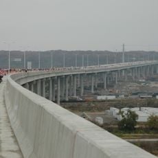
One section features an exceptionally long bridge that crosses the Des Plaines River Valley, carrying traffic over multiple waterways and rail lines in a single span. This engineering solution allows the road to maintain its route without major detours through the landscape.

The community of curious travelers

AroundUs brings together thousands of curated places, local tips, and hidden gems, enriched daily by 60,000 contributors worldwide.

Start exploring
Location
Location
Location
Inception
1989
GPS coordinates
41.75070,-88.03543
Latest update
December 20, 2025 13:22
Around this place
Morton Arboretum
United States of America

Morton Arboretum

7.8 km
The Avery Coonley School
United States of America

The Avery Coonley School

4.3 km
Centennial Beach
United States of America

Centennial Beach

10.3 km
Moser Tower and Millennium Carillon
United States of America

Moser Tower and Millennium Carillon

10.3 km
Waterfall Glen Forest Preserve
United States of America

Waterfall Glen Forest Preserve

5.9 km
Benedetti–Wehrli Stadium
United States of America

Benedetti–Wehrli Stadium

9.4 km
United States of America

The Forge: Lemont Quarries Adventure Park

8.9 km
Village of Lisle-Benedictine University Sports Complex
United States of America

Village of Lisle-Benedictine University Sports Complex

5.9 km
Des Plaines River Valley Bridge
United States of America

Des Plaines River Valley Bridge

8.7 km
Naperville Historic District
United States of America

Naperville Historic District

10.1 km
Francis Stuyvesant Peabody House
United States of America

Francis Stuyvesant Peabody House

10.4 km
Downtown Hinsdale Historic District
United States of America

Downtown Hinsdale Historic District

10.5 km
United States of America

Cypress Cove Family Aquatic Park

1.8 km
Russell R. Kirt Prairie
United States of America

Russell R. Kirt Prairie

10.5 km
Immanuel Hall
United States of America

Immanuel Hall

10.1 km
Old Nichols Library
United States of America

Old Nichols Library

9.7 km
Baitul Jaamay Mosque, Glen Ellyn
United States of America

Baitul Jaamay Mosque, Glen Ellyn

9.6 km
Pelican Harbor Indoor Outdoor Aquatic Park
United States of America

Pelican Harbor Indoor Outdoor Aquatic Park

8.8 km
William L. Gregg House
United States of America

William L. Gregg House

7 km
Robert A. and Mary Childs House
United States of America

Robert A. and Mary Childs House

10.4 km
Lemont Downtown Historic District
United States of America

Lemont Downtown Historic District

9 km
Lemont Central Grade School
United States of America

Lemont Central Grade School

9.3 km
Lemont Methodist Episcopal Church
United States of America

Lemont Methodist Episcopal Church

9.1 km
William and Helen Coffeen House
United States of America

William and Helen Coffeen House

10.5 km
National Shrine of St Therese
United States of America

National Shrine of St Therese

5.2 km
Centennial Park
United States of America

Centennial Park

10.5 km
Sea Lion Aquatic Park
United States of America

Sea Lion Aquatic Park

6 km
Naper Settlement
United States of America

Naper Settlement

10 km
Show the full map
Reviews
Share your experience

No review yet

Discussions
Start a discussion...

No discussion yet

« Interstate 355 - Interstate highway in western Chicago suburbs, Illinois » is provided by Around Us (aroundus.com). Images and texts are derived from Wikimedia project under a Creative Commons license. You are allowed to copy, distribute, and modify copies of this page, under the conditions set by the license, as long as this note is clearly visible.

Discover hidden gems everywhere you go!

From secret cafés to breathtaking viewpoints, skip the crowded tourist spots and find places that match your style. Our app makes it easy with voice search, smart filtering, route optimization, and insider tips from travelers worldwide. Download now for the complete mobile experience.

Around Us App Screenshot

A unique approach to discovering new places

Le Figaro

All the places worth exploring

France Info

A tailor-made excursion in just a few clicks

20 Minutes

Around Us
Travel Guide & Maps
Download

Send to your phone

QR Code
1

Open the camera app on your mobile.

2

Point at the QR code with your camera. A notification will appear.

3

Tap the notification to open the link.