Bellefontaine

Log in to your account

AroundUs is a community-driven map of interesting places, built by curious explorers like you. It grows with every review, story, and photo you share.
Connect to save your favorite spots, contribute locations, and create personalized routes.
By continuing, you accept our Terms and Conditions and our Privacy Policy
Add to collection
Map
Suggest a change
Share

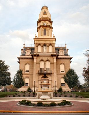
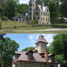
Bellefontaine, County seat in Logan County, Ohio, United States.

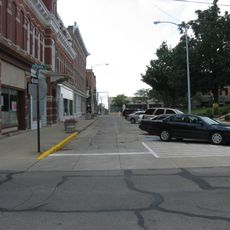
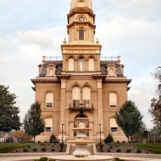
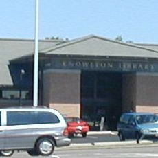
Bellefontaine is a city in Logan County, Ohio, located at 379 meters above sea level with several natural springs throughout the region. The city center contains multiple government buildings, including the courthouse, while major highways US-33 and US-68 pass through the municipality.

The city was founded in 1817 as a trading post and gained importance as a central hub for Mad River and Lake Erie Railroad operations. This railroad connection became essential to the community's economic growth and expansion.

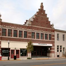
The Holland Theater displays its original 1931 design with Dutch architectural influences and continues to host performances for the local community. The building reflects the era when it was constructed and attracts visitors interested in classic theater design.

The city center is easy to navigate, with the courthouse serving as a landmark and clear signage along the main highways. The two highways provide convenient entry and exit points, making it easy to explore different parts of the city.

In 1891, George Bartholomew paved Court Avenue as the nation's first concrete street, marking an important moment in American infrastructure history. This innovative construction demonstrated concrete's durability and influenced road building practices across the country.

Location: Logan County

Inception: 1817

Elevation above the sea: 379 m

Shares border with: Columbus

Address: Bellefontaine, OH 43311, USA

Website: http://ci.bellefontaine.oh.us

GPS coordinates: 40.36080,-83.75810

Latest update: December 6, 2025 22:07

Photos
Around this place
Show the full map
Campbell Hill
United States of America

Campbell Hill

3.4 km
Indian Lake
United States of America

Indian Lake

15.5 km
Piatt Castles
United States of America

Piatt Castles

12.5 km
Ohio Caverns
United States of America

Ohio Caverns

14.6 km
J.H. Manchester Round Barn
United States of America

J.H. Manchester Round Barn

24.8 km
Zane Shawnee Caverns
United States of America

Zane Shawnee Caverns

10.6 km
Champaign Aviation Museum
United States of America

Champaign Aviation Museum

25.2 km
Dunns Pond Mound
United States of America

Dunns Pond Mound

15.6 km
Zimmerman Kame
United States of America

Zimmerman Kame

24.2 km
Logan County Courthouse
United States of America

Logan County Courthouse

94 m
Siegenthaler-Kaestner Esker State Nature Preserve
United States of America

Siegenthaler-Kaestner Esker State Nature Preserve

16.9 km
Schine Holland Theatre
United States of America

Schine Holland Theatre

75 m
Lake Ridge Island Mounds
United States of America

Lake Ridge Island Mounds

16.8 km
Mount Tabor Methodist Episcopal Church
United States of America

Mount Tabor Methodist Episcopal Church

15.7 km
McColly Covered Bridge
United States of America

McColly Covered Bridge

14.8 km
William Lawrence House
United States of America

William Lawrence House

517 m
The Fort
United States of America

The Fort

22.7 km
Martin Marmon House
United States of America

Martin Marmon House

8.6 km
Champaign Aviation Museum
United States of America

Champaign Aviation Museum

25.2 km
Mac-O-Chee Castle
United States of America

Mac-O-Chee Castle

11.9 km
Logan County History Center
United States of America

Logan County History Center

625 m
Spain Creek Covered Bridge
United States of America

Spain Creek Covered Bridge

24.8 km
Campbell Hill
United States of America

Campbell Hill

3.4 km
Pottersburg Covered Bridge
United States of America

Pottersburg Covered Bridge

23.6 km
Knowlton Library
United States of America

Knowlton Library

306 m
Flatwoods Schoolhouse
United States of America

Flatwoods Schoolhouse

18.6 km
Bickham Covered Bridge
United States of America

Bickham Covered Bridge

14.4 km
Sandy Beach Amusement Park
United States of America

Sandy Beach Amusement Park

17 km
Show the full map
Reviews

Visited this place? Tap the stars to rate it and share your experience / photos with the community! Try now! You can cancel it anytime.

« Bellefontaine - County seat in Logan County, Ohio, United States » is provided by Around Us (aroundus.com). Images and texts are derived from Wikimedia project under a Creative Commons license. You are allowed to copy, distribute, and modify copies of this page, under the conditions set by the license, as long as this note is clearly visible.

Discover hidden gems everywhere you go!

From secret cafés to breathtaking viewpoints, skip the crowded tourist spots and find places that match your style. Our app makes it easy with voice search, smart filtering, route optimization, and insider tips from travelers worldwide. Download now for the complete mobile experience.

Around Us App Screenshot

A unique approach to discovering new places

Le Figaro

All the places worth exploring

France Info

A tailor-made excursion in just a few clicks

20 Minutes