Enable Location

We need your location to show you interesting places around you

Discover nearby places

Find interesting locations and hidden gems around you

Precise directions

Get accurate directions and distances to places

Your location is never shared with other users. It's only used when you tap the location button.

Campbell Hill

Log in to your account

Start exploring — it's free

Trusted by 61,520 travelers worldwide

Continue with Google
Continue with Apple
or

We will send you a code to connect

By continuing, you accept our Terms and Conditions and our Privacy Policy

Check your inbox

We've sent a pincode in your inbox. Please enter the code below.

Campbell Hill

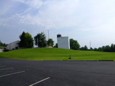
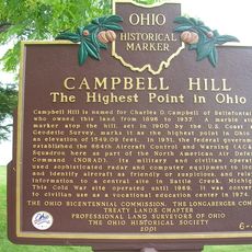
Campbell Hill, Mountain summit in Bellefontaine, Ohio, US.

Description

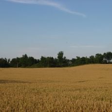
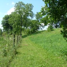
Campbell Hill is a mountain summit in Bellefontaine, Ohio, rising 472 meters above sea level and marking the highest elevation point in the state. The surrounding area features flat agricultural land and gentle slopes that extend down from the peak.

History

The Federal government acquired Campbell Hill in 1950 and established a military radar station for the 664th Aircraft Control and Warning Squadron during the Cold War. The facility played a role in the region's air defense strategy of that era.

Culture

The Ohio Hi-Point Career Center has operated on the summit since 1974, bringing vocational training to the region while maintaining public access to the geographical landmark. The school represents how education and local identity blend at this elevated location.

Practical

The summit is accessible on weekdays from 6:30 AM to 10:00 PM, with parking available at the vocational school facility on the grounds. Weekend access may be limited depending on school activities.

Did you know?

The location serves as the headwater source for the Mad River, one of Ohio's most important coldwater fisheries featuring limestone gorges along its course. This hydrological role extends the hill's significance beyond its status as a geographical marker.

Location
Elevation above the sea
472 m
GPS coordinates
40.37016,-83.72007
Latest update
December 17, 2025 09:08

AroundUs brings together thousands of curated places, local tips, and hidden gems, enriched daily by 60,000 contributors worldwide. Discover all places nearby (Ohio).

Around this place
Indian Lake
United States of America

Indian Lake

17 km
Piatt Castles
United States of America

Piatt Castles

13.3 km
Ohio Caverns
United States of America

Ohio Caverns

14.8 km
J.H. Manchester Round Barn
United States of America

J.H. Manchester Round Barn

25.5 km
Zane Shawnee Caverns
United States of America

Zane Shawnee Caverns

7.3 km
Court Avenue
United States of America

Court Avenue

3.5 km
Champaign Aviation Museum
United States of America

Champaign Aviation Museum

26.3 km
Dunns Pond Mound
United States of America

Dunns Pond Mound

16.9 km
Zimmerman Kame
United States of America

Zimmerman Kame

24.1 km
Logan County Courthouse
United States of America

Logan County Courthouse

3.5 km
Siegenthaler-Kaestner Esker State Nature Preserve
United States of America

Siegenthaler-Kaestner Esker State Nature Preserve

19.5 km
Schine Holland Theatre
United States of America

Schine Holland Theatre

3.4 km
Lake Ridge Island Mounds
United States of America

Lake Ridge Island Mounds

17.9 km
Mount Tabor Methodist Episcopal Church
United States of America

Mount Tabor Methodist Episcopal Church

15.9 km
McColly Covered Bridge
United States of America

McColly Covered Bridge

17.6 km
William Lawrence House
United States of America

William Lawrence House

3.4 km
The Fort
United States of America

The Fort

21.1 km
Martin Marmon House
United States of America

Martin Marmon House

6.5 km
Mount Victory Historic District
United States of America

Mount Victory Historic District

24.9 km
Champaign Aviation Museum
United States of America

Champaign Aviation Museum

26.3 km
Mac-O-Chee Castle
United States of America

Mac-O-Chee Castle

12.4 km
Logan County History Center
United States of America

Logan County History Center

2.8 km
Spain Creek Covered Bridge
United States of America

Spain Creek Covered Bridge

23 km
Campbell Hill
United States of America

Campbell Hill

14 m
Knowlton Library
United States of America

Knowlton Library

3.4 km
Pottersburg Covered Bridge
United States of America

Pottersburg Covered Bridge

21.7 km
Bickham Covered Bridge
United States of America

Bickham Covered Bridge

15.4 km
Flatwoods Schoolhouse
United States of America

Flatwoods Schoolhouse

15.2 km
Show the full map
« Campbell Hill - Mountain summit in Bellefontaine, Ohio, US » is provided by Around Us (aroundus.com). Images and texts are derived from Wikimedia project under a Creative Commons license. You are allowed to copy, distribute, and modify copies of this page, under the conditions set by the license, as long as this note is clearly visible.

Discover hidden gems everywhere you go!

From secret cafés to breathtaking viewpoints, skip the crowded tourist spots and find places that match your style. Our app makes it easy with voice search, smart filtering, route optimization, and insider tips from travelers worldwide. Download now for the complete mobile experience.

Around Us App Screenshot

A unique approach to discovering new places

Le Figaro

All the places worth exploring

France Info

A tailor-made excursion in just a few clicks

20 Minutes

Around Us
Travel Guide & Maps
Download

Send to your phone

QR Code
1

Open the camera app on your mobile.

2

Point at the QR code with your camera. A notification will appear.

3

Tap the notification to open the link.