Jefferson Davis Highway

Log in to your account

AroundUs is a community-driven map of interesting places, built by curious explorers like you. It grows with every review, story, and photo you share.
Connect to save your favorite spots, contribute locations, and create personalized routes.
By continuing, you accept our Terms and Conditions and our Privacy Policy

Jefferson Davis Highway

Add to collection
Map
Suggest a change
Share

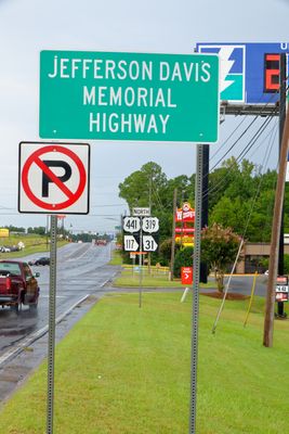
Jefferson Davis Highway, Memorial road across Alabama and California, United States.

Jefferson Davis Highway is a historic road network spanning from Virginia through eleven states to California, connecting diverse American regions. The route is traced today by modern highways including US 1, 15, 29, 61, 80, and 90 that follow its original path.

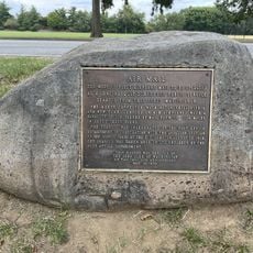
The road was initiated in 1913 by the United Daughters of the Confederacy as a transcontinental project connecting the eastern and western coasts. The project grew into a major transportation corridor during the early automobile era.

The road sections in Alabama and California represent different regional interpretations of American transportation development during the automobile age.

Individual segments of this historic route can be experienced today as a drive through multiple states, with marked highways providing the best guidance. Visitors should plan carefully since the route is quite long and spans diverse landscapes and conditions.

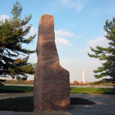
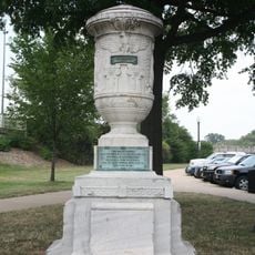
President Warren Harding marked the western terminus in 1921 with a ceremonial dedication in San Diego, bringing significant national attention to the young automobile culture. This event highlighted the road's importance in connecting America during a transformative time.

Location: Alabama

Location: Arizona

Location: California

Location: Georgia

Location: Louisiana

Location: Mississippi

Location: New Mexico

Location: North Carolina

Location: South Carolina

Location: Texas

Location: Virginia

Inception: 1913

Website: http://fhwa.dot.gov/infrastructure/jdavis.htm

GPS coordinates: 38.86690,-77.04770

Latest update: December 7, 2025 10:01

Photos
Around this place
Show the full map
The Pentagon
United States of America

The Pentagon

769 m
Ronald Reagan Washington National Airport
United States of America

Ronald Reagan Washington National Airport

1.5 km
Jefferson Memorial
United States of America

Jefferson Memorial

1.9 km
Pentagon Memorial
United States of America

Pentagon Memorial

1.1 km
National Military Command Center
United States of America

National Military Command Center

829 m
United States Air Force Memorial
United States of America

United States Air Force Memorial

1.6 km
Victims of Terrorist Attack on the Pentagon Memorial
United States of America

Victims of Terrorist Attack on the Pentagon Memorial

1.4 km
14th Street Bridges
United States of America

14th Street Bridges

1.1 km
George Mason Memorial
United States of America

George Mason Memorial

1.6 km
Lyndon Baines Johnson Memorial Grove on the Potomac
United States of America

Lyndon Baines Johnson Memorial Grove on the Potomac

1.3 km
Navy – Merchant Marine Memorial
United States of America

Navy – Merchant Marine Memorial

1 km
Arlington Farms
United States of America

Arlington Farms

1.8 km
Navy Annex
United States of America

Navy Annex

1.9 km
Cuban Friendship Urn
United States of America

Cuban Friendship Urn

1.5 km
Aurora Highlands Historic District
United States of America

Aurora Highlands Historic District

1.7 km
Synetic Theater
United States of America

Synetic Theater

1.1 km
Fort Jackson
United States of America

Fort Jackson

678 m
Long Bridge
United States of America

Long Bridge

1.2 km
Fort Runyon
United States of America

Fort Runyon

388 m
Bridge Tender's House
United States of America

Bridge Tender's House

1.2 km
Fort Albany
United States of America

Fort Albany

1.6 km
Grace Murray Hopper Park
United States of America

Grace Murray Hopper Park

1.5 km
Prospect Hill
United States of America

Prospect Hill

1.6 km
Japanese Pagoda
United States of America

Japanese Pagoda

1.8 km
Lady Bird Johnson Park
United States of America

Lady Bird Johnson Park

1.2 km
Aurora Hills Library
United States of America

Aurora Hills Library

1.4 km
National Capital Parks Headquarters
United States of America

National Capital Parks Headquarters

1.6 km
Air Mail Marker
United States of America

Air Mail Marker

1.7 km
Show the full map
Reviews

Visited this place? Tap the stars to rate it and share your experience / photos with the community! Try now! You can cancel it anytime.

« Jefferson Davis Highway - Memorial road across Alabama and California, United States » is provided by Around Us (aroundus.com). Images and texts are derived from Wikimedia project under a Creative Commons license. You are allowed to copy, distribute, and modify copies of this page, under the conditions set by the license, as long as this note is clearly visible.

Discover hidden gems everywhere you go!

From secret cafés to breathtaking viewpoints, skip the crowded tourist spots and find places that match your style. Our app makes it easy with voice search, smart filtering, route optimization, and insider tips from travelers worldwide. Download now for the complete mobile experience.

Around Us App Screenshot

A unique approach to discovering new places

Le Figaro

All the places worth exploring

France Info

A tailor-made excursion in just a few clicks

20 Minutes