Enable Location

We need your location to show you interesting places around you

Discover nearby places

Find interesting locations and hidden gems around you

Precise directions

Get accurate directions and distances to places

Your location is never shared with other users. It's only used when you tap the location button.

Raven Rock Mountain Complex

Log in to your account

Start exploring — it's free

Trusted by 61,759 travelers worldwide

Continue with Google
Continue with Apple
or

We will send you a code to connect

By continuing, you accept our Terms and Conditions and our Privacy Policy

Check your inbox

We've sent a pincode in your inbox. Please enter the code below.

Raven Rock Mountain Complex

Raven Rock Mountain Complex, Military bunker in Liberty Township, Pennsylvania.

Description

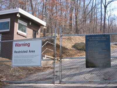
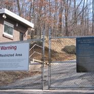
The Raven Rock Mountain Complex is a military facility carved inside a mountain in Liberty Township, Pennsylvania, close to the Maryland border. The underground structure includes several buildings, rooms for technical equipment, supply facilities, and offices connected by a network of tunnels and corridors.

History

The construction of this facility began around 1950 as a protected command post in case of nuclear conflict, with land acquired by federal authorities. The facility was expanded and modernized several times during the Cold War to serve as an emergency center for military leadership.

Culture

The facility earned the informal name 'Harry's Hole' among local residents, referring to President Truman's involvement in establishing this underground military base.

Practical

The facility is not open to the public and remains in active use for military purposes, with strict security measures around the site. Visitors without clearance are not allowed to approach the entrance area or take photographs of the secured access points.

Did you know?

On September 11, 2001, this site served as a refuge for senior government officials to ensure continuity of state leadership. Among local residents, the facility was known by an informal name that alluded to President Truman and his role in its establishment.

Location
Inception
1951
Address
Outer Roadway
GPS coordinates
39.73400,-77.41900
Latest update
December 14, 2025 22:42

AroundUs brings together thousands of curated places, local tips, and hidden gems, enriched daily by 60,000 contributors worldwide. Discover all places nearby (Pennsylvania).

Secret military sites and underground facilities around the world

This collection brings together underground military sites, strategic bunkers, and highly secured installations across the world. Many of these places were built during the Cold War, when nuclear threats pushed governments to create protected command centers deep under mountains or in remote areas....

Around this place
National Shrine of St. Elizabeth Ann Seton
United States of America

National Shrine of St. Elizabeth Ann Seton

8.5 km
United States of America

Pen Mar Park

7.9 km
United States of America

Monterey Country Club

4.5 km
Fairfield Inn
United States of America

Fairfield Inn

7.2 km
Victor Cullen Center, Old Administration Building
United States of America

Victor Cullen Center, Old Administration Building

4.1 km
Jacks Mountain Covered Bridge
United States of America

Jacks Mountain Covered Bridge

4.6 km
Monterey Historic District
United States of America

Monterey Historic District

4.3 km
Fairfield Historic District
United States of America

Fairfield Historic District

7.8 km
Emmitsburg Historic District
United States of America

Emmitsburg Historic District

8.4 km
Victor Cullen School Power House
United States of America

Victor Cullen School Power House

4.3 km
United States of America

Strawberry Hill Nature Preserve

7.8 km
St. Euphemia's School and Sisters' House
United States of America

St. Euphemia's School and Sisters' House

8.6 km
Tipahato
United States of America

Tipahato

6.7 km
United States of America

Red Run Lodge

8.4 km
United States of America

Clermont Crag

5.6 km
United States of America

St. Francis

7.8 km
United States of America

Marion Burk Knott Auditorium

8.3 km
United States of America

Old Benjamin Omanut

7.6 km
United States of America

Beach Front

7.4 km
United States of America

Fr. John Dubois

8.1 km
United States of America

Teatron

6.9 km
United States of America

The Miller Family Visitors Center

7.9 km
United States of America

Statue, Work of art

7.2 km
United States of America

Rattlesnake Run Lookout

7 km
United States of America

Scenic viewpoint

6.7 km
United States of America

Scenic viewpoint

6.2 km
United States of America

Scenic viewpoint

6.2 km
United States of America

Scenic viewpoint

7.9 km
Show the full map
« Raven Rock Mountain Complex - Military bunker in Liberty Township, Pennsylvania » is provided by Around Us (aroundus.com). Images and texts are derived from Wikimedia project under a Creative Commons license. You are allowed to copy, distribute, and modify copies of this page, under the conditions set by the license, as long as this note is clearly visible.

Discover hidden gems everywhere you go!

From secret cafés to breathtaking viewpoints, skip the crowded tourist spots and find places that match your style. Our app makes it easy with voice search, smart filtering, route optimization, and insider tips from travelers worldwide. Download now for the complete mobile experience.

Around Us App Screenshot

A unique approach to discovering new places

Le Figaro

All the places worth exploring

France Info

A tailor-made excursion in just a few clicks

20 Minutes

Around Us
Travel Guide & Maps
Download

Send to your phone

QR Code
1

Open the camera app on your mobile.

2

Point at the QR code with your camera. A notification will appear.

3

Tap the notification to open the link.