Sandwich

Log in to your account

AroundUs is a community-driven map of interesting places, built by curious explorers like you. It grows with every review, story, and photo you share.
Connect to save your favorite spots, contribute locations, and create personalized routes.
Continue with Google
Continue with Apple
Continue with X
Continue with Facebook
Continue with email
By continuing, you accept our Terms and Conditions and our Privacy Policy
Create an account
Add to collection
Map
Suggest a change
Share

Sandwich, Colonial settlement in Barnstable County, Massachusetts.

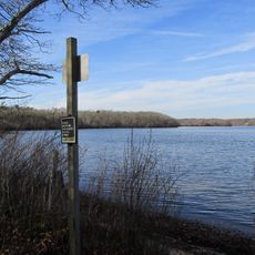
Sandwich is a coastal town on Cape Cod Bay in Massachusetts that spreads across forests, ponds, and sandy shores. The landscape features low-lying terrain with white sand beaches, wooded areas, and freshwater ponds scattered throughout the community.

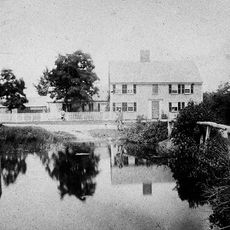
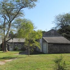
The settlement began in 1637 when people from Saugus arrived with permission from Plymouth Colony, making it the oldest town on Cape Cod. The 1800s brought a glass factory that became well-known for producing fine glassware and shaped the town's economy for decades.

The town's glass-making heritage shaped how people saw craft and industry in the 1800s, with locally produced glassware gaining fame across the country. Walking through the community today, you notice how this industrial past remains woven into local identity and pride.

Getting around town is straightforward with roads connecting coastal and inland areas, though traffic can build up during summer months. Spring through fall offers the most pleasant conditions for exploring beaches and walking through woodlands.

A working grist mill from 1637 still stands in its original location and grinds grain using water power the way it did centuries ago. This functioning building offers a rare look at how early settlers handled daily tasks.

Location: Barnstable County

Inception: 1637

Elevation above the sea: 6 m

Website: http://sandwichmass.org

GPS coordinates: 41.75889,-70.49444

Latest update: December 17, 2025 08:57

Photos
Around this place
Sagamore Bridge
United States of America

Sagamore Bridge

4.5 km
Scusset Beach State Reservation
United States of America

Scusset Beach State Reservation

2.3 km
Heritage Museums and Gardens
United States of America

Heritage Museums and Gardens

1.5 km
Sandwich Glass Museum
United States of America

Sandwich Glass Museum

504 m
Hoxie House
United States of America

Hoxie House

507 m
Fort Banks
United States of America

Fort Banks

7.2 km
Wing Fort House
United States of America

Wing Fort House

2.6 km
Shawme-Crowell State Forest
United States of America

Shawme-Crowell State Forest

2.6 km
Pine Hill
United States of America

Pine Hill

8.1 km
United States of America

Frances A. Crane Wildlife Management Area

14.6 km
Lowell Holly Reservation
United States of America

Lowell Holly Reservation

10.3 km
United States of America

Third Cape Cod Canal road bridge

4.5 km
First Church, Sandwich Massachusetts
United States of America

First Church, Sandwich Massachusetts

441 m
United States of America

Cahoon Museum of American Art

13.9 km
Benjamin Nye Homestead
United States of America

Benjamin Nye Homestead

6.2 km
Santuit Historic District
United States of America

Santuit Historic District

14 km
Mashpee Wampanoag Indian Museum
United States of America

Mashpee Wampanoag Indian Museum

12.2 km
Goodspeed House
United States of America

Goodspeed House

12.8 km
William Marston House
United States of America

William Marston House

13.6 km
Jarvesville Historic District
United States of America

Jarvesville Historic District

45 m
Forestdale School
United States of America

Forestdale School

7.5 km
John and Mary Waterman Jarves House
United States of America

John and Mary Waterman Jarves House

152 m
Adams-Crocker-Fish House
United States of America

Adams-Crocker-Fish House

10.8 km
Avant House
United States of America

Avant House

12.2 km
Matthias Smith House
United States of America

Matthias Smith House

10.2 km
United States of America

Thornton W. Burgess Museum

507 m
Town Boundary Marker
United States of America

Town Boundary Marker

9.4 km
Spring Hill Historic District (Sandwich, Massachusetts)
United States of America

Spring Hill Historic District (Sandwich, Massachusetts)

2.2 km
Show the full map
Reviews

Visited this place? Tap the stars to rate it and share your experience / photos with the community! Try now! You can cancel it anytime.

« Sandwich - Colonial settlement in Barnstable County, Massachusetts » is provided by Around Us (aroundus.com). Images and texts are derived from Wikimedia project under a Creative Commons license. You are allowed to copy, distribute, and modify copies of this page, under the conditions set by the license, as long as this note is clearly visible.

Discover hidden gems everywhere you go!

From secret cafés to breathtaking viewpoints, skip the crowded tourist spots and find places that match your style. Our app makes it easy with voice search, smart filtering, route optimization, and insider tips from travelers worldwide. Download now for the complete mobile experience.

Around Us App Screenshot

A unique approach to discovering new places

Le Figaro

All the places worth exploring

France Info

A tailor-made excursion in just a few clicks

20 Minutes