·

Enable Location

We need your location to show you interesting places around you

Discover nearby places

Find interesting locations and hidden gems around you

Precise directions

Get accurate directions and distances to places

Your location is never shared with other users. It's only used when you tap the location button.

Staten Island Ferry

Log in to your account

Start exploring — it's free

Trusted by 62,724 travelers worldwide

Continue with Google
Continue with Apple
or

We will send you a code to connect

By continuing, you accept our Terms and Conditions and our Privacy Policy

Check your inbox

We've sent a pincode in your inbox. Please enter the code below.

Staten Island Ferry

Staten Island Ferry, Ferry route in New York Harbor, US

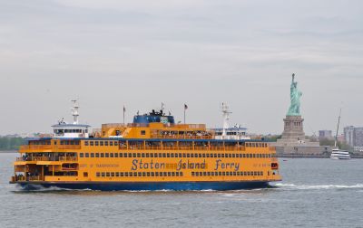
The Staten Island Ferry connects Lower Manhattan with Staten Island through a regular boat service across New York Harbor. The ride takes about 25 minutes and passes directly by the Statue of Liberty and Ellis Island, giving passengers a clear view of both.

The service began in the early 19th century as a private connection and was later taken over by the City of New York. It grew into one of the busiest ferry routes in the country, with the original fare eventually eliminated.

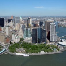
The ride between the two shores attracts commuters and travelers every day who look out from the large windows at the Statue of Liberty and the Manhattan skyline. Many use the time on board to rest or take photos while the boat glides through the harbor water.

The crossing is free of charge and operates around the clock, with more frequent departures during the day than at night. Waiting areas are available at the terminals, and the upper outdoor decks offer good views, though they are exposed to wind or cold.

The fleet consists of three active vessels, each named after former mayors of the city. Each boat can carry up to 4,400 passengers, making them some of the largest passenger vessels operating in American waters.

The community of curious travelers

AroundUs brings together thousands of curated places, local tips, and hidden gems, enriched daily by 60,000 contributors worldwide.

Start exploring
Location
Inception
1817
Official opening
1817
Part of
public transport networks in New York
GPS coordinates
40.70141,-74.01319
Latest update
December 12, 2025 22:15
Filming locations of the very famous series Sex and the City

Follow the steps of the four heroines of Sex and the City to the real places where their adventures were filmed in New York and Paris.

Around this place
The Battery
United States of America

The Battery

348 m
Castle Clinton
United States of America

Castle Clinton

382 m
Bowling Green
United States of America

Bowling Green

401 m
Alexander Hamilton U.S. Custom House
United States of America

Alexander Hamilton U.S. Custom House

325 m
Fort Amsterdam
United States of America

Fort Amsterdam

292 m
26 Broadway
United States of America

26 Broadway

433 m
Stone Street
United States of America

Stone Street

379 m
2 Broadway
United States of America

2 Broadway

351 m
New York Cotton Exchange
United States of America

New York Cotton Exchange

418 m
Government House
United States of America

Government House

338 m
SeaGlass Carousel
United States of America

SeaGlass Carousel

176 m
New York City Police Museum
United States of America

New York City Police Museum

484 m
Battery Maritime Building
United States of America

Battery Maritime Building

130 m
1 Broadway
United States of America

1 Broadway

405 m
17 State Street
United States of America

17 State Street

163 m
2 New York Plaza
United States of America

2 New York Plaza

248 m
New York Produce Exchange
United States of America

New York Produce Exchange

369 m
James Watson House
United States of America

James Watson House

126 m
Vietnam Veterans Plaza
United States of America

Vietnam Veterans Plaza

319 m
National Museum of the American Indian George Gustav Heye Center
United States of America

National Museum of the American Indian George Gustav Heye Center

295 m
American Bank Note Company Building
United States of America

American Bank Note Company Building

373 m
Sports Museum of America
United States of America

Sports Museum of America

411 m
Helicoidal Skyscraper
United States of America

Helicoidal Skyscraper

120 m
St. George Coast Guard Station
United States of America

St. George Coast Guard Station

104 m
East Coast Memorial
United States of America

East Coast Memorial

248 m
Battery Park Control House
United States of America

Battery Park Control House

315 m
Fraunces Tavern Block
United States of America

Fraunces Tavern Block

263 m
Diker Pavilion for Native Arts and Cultures
United States of America

Diker Pavilion for Native Arts and Cultures

386 m
Show the full map
« Staten Island Ferry - Ferry route in New York Harbor, US » is provided by Around Us (aroundus.com). Images and texts are derived from Wikimedia project under a Creative Commons license. You are allowed to copy, distribute, and modify copies of this page, under the conditions set by the license, as long as this note is clearly visible.

Discover hidden gems everywhere you go!

From secret cafés to breathtaking viewpoints, skip the crowded tourist spots and find places that match your style. Our app makes it easy with voice search, smart filtering, route optimization, and insider tips from travelers worldwide. Download now for the complete mobile experience.

Around Us App Screenshot

A unique approach to discovering new places

Le Figaro

All the places worth exploring

France Info

A tailor-made excursion in just a few clicks

20 Minutes

Around Us
Travel Guide & Maps
Download

Send to your phone

QR Code
1

Open the camera app on your mobile.

2

Point at the QR code with your camera. A notification will appear.

3

Tap the notification to open the link.