Enable Location

We need your location to show you interesting places around you

Discover nearby places

Find interesting locations and hidden gems around you

Precise directions

Get accurate directions and distances to places

Your location is never shared with other users. It's only used when you tap the location button.

Ocala National Forest

Log in to your account

Start exploring — it's free

Trusted by 69,373 travelers worldwide

Continue with Google
Continue with Apple
or

We will send you a code to connect

By continuing, you accept our Terms and Conditions and our Privacy Policy

Check your inbox

We've sent a pincode in your inbox. Please enter the code below.

Discussion Reviews 2 Photos
31.8k Popularity

Ocala National Forest, National forest in north central Florida, United States

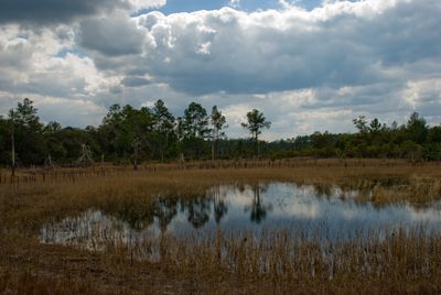
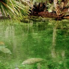
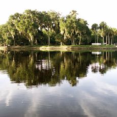
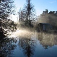
Ocala National Forest is a large protected woodland in central Florida stretching between two major rivers and covering roughly 607 square miles. The land contains pine forests mixed with wetlands, and visitors can find numerous freshwater springs scattered throughout the area.

This protected forest was established in 1908, making it one of the oldest national forests east of the Mississippi River at that time. It also became the southernmost national forest in the continental United States when it was created.

The name comes from the Timucuan language and means 'fair land' or 'big hammock', honoring the Native American people who lived here long ago. Walking through the forest, you sense this connection to the land that indigenous residents once knew.

The forest has several camping areas and recreation sites with facilities available throughout the year for outdoor activities. Visitors should prepare for changing conditions depending on the season and come equipped for the specific weather they may encounter.

A portion of this forest serves as a live training range where the United States Navy practices with real weapons. This is the only active naval bombing training area located along the East Coast.

The community of curious travelers

AroundUs brings together thousands of curated places, local tips, and hidden gems, enriched daily by 60,000 contributors worldwide.

Start exploring
Location
Inception
1908
Operator
United States Forest Service
GPS coordinates
29.17360,-81.82170
Latest update
December 20, 2025 00:59
Around this place
Majesty Building
United States of America

Majesty Building

69.9 km
The Senator
United States of America

The Senator

69.5 km
Blue Spring State Park
United States of America

Blue Spring State Park

53.2 km
Central Florida Zoo and Botanical Gardens
United States of America

Central Florida Zoo and Botanical Gardens

62.5 km
De Leon Springs State Park
United States of America

De Leon Springs State Park

44.2 km
Bulow Plantation Ruins Historic State Park
United States of America

Bulow Plantation Ruins Historic State Park

72.2 km
Volusia Speedway Park
United States of America

Volusia Speedway Park

46.6 km
Spec Martin Stadium
United States of America

Spec Martin Stadium

53.5 km
Municipal Stadium
United States of America

Municipal Stadium

68.4 km
Hontoon Island State Park
United States of America

Hontoon Island State Park

50.2 km
United States of America

Rodman Reservoir

38.3 km
Lake Griffin State Park
United States of America

Lake Griffin State Park

35.2 km
United States of America

Rock Springs Run State Reserve

62.6 km
United States of America

Bulow Creek State Park

71.8 km
United States of America

Gamble Rogers Memorial State Recreation Area at Flagler Beach

74.9 km
Howey House
United States of America

Howey House

50.4 km
United States of America

DeLand Naval Air Station

53.6 km
United States of America

Lake Woodruff National Wildlife Refuge

39.1 km
Downtown DeLand Historic District
United States of America

Downtown DeLand Historic District

52.8 km
United States of America

Tiger Bay State Forest

62.4 km
Little Big Econ State Forest
United States of America

Little Big Econ State Forest

87.6 km
Lakeside Inn
United States of America

Lakeside Inn

45.2 km
United States of America

Alexander Springs Wilderness

36 km
John B. Stetson House
United States of America

John B. Stetson House

51.3 km
Lake George State Forest
United States of America

Lake George State Forest

37.3 km
United States of America

Flea World

68.2 km
United States of America

Cross Seminole Trail

73.2 km
United States of America

Lower Wekiva River Preserve State Park

55.8 km
Show the full map
Reviews
Share your experience

No review yet

Discussions
Start a discussion...

No discussion yet

« Ocala National Forest - National forest in north central Florida, United States » is provided by Around Us (aroundus.com). Images and texts are derived from Wikimedia project under a Creative Commons license. You are allowed to copy, distribute, and modify copies of this page, under the conditions set by the license, as long as this note is clearly visible.

Discover hidden gems everywhere you go!

From secret cafés to breathtaking viewpoints, skip the crowded tourist spots and find places that match your style. Our app makes it easy with voice search, smart filtering, route optimization, and insider tips from travelers worldwide. Download now for the complete mobile experience.

Around Us App Screenshot

A unique approach to discovering new places

Le Figaro

All the places worth exploring

France Info

A tailor-made excursion in just a few clicks

20 Minutes

Around Us
Travel Guide & Maps
Download

Send to your phone

QR Code
1

Open the camera app on your mobile.

2

Point at the QR code with your camera. A notification will appear.

3

Tap the notification to open the link.