Enable Location

We need your location to show you interesting places around you

Discover nearby places

Find interesting locations and hidden gems around you

Precise directions

Get accurate directions and distances to places

Your location is never shared with other users. It's only used when you tap the location button.

New River Gorge Bridge

Log in to your account

Join the adventure

Create your free account and start exploring (like 60k+ others)

We will send you a code to connect

or
Continue with Google
Continue with Apple
By continuing, you accept our Terms and Conditions and our Privacy Policy

Check your inbox

We've sent a pincode in your inbox. Please enter the code below.

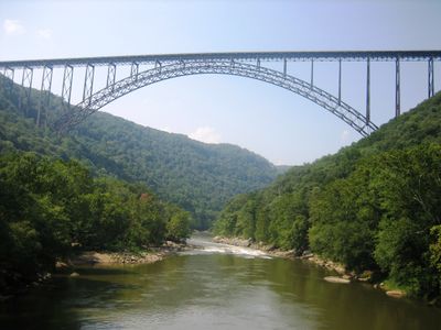
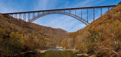
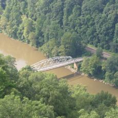
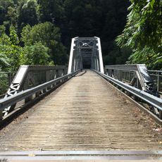
New River Gorge Bridge, Steel arch bridge in Fayetteville, United States.

Description

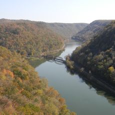
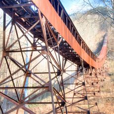
New River Gorge Bridge is a steel arch bridge in Fayetteville, United States, that spans 924 meters across a deep canyon. The structure rises 267 meters above the water, with a main arch measuring 518 meters from end to end.

History

Construction began in June 1974 and took three years to complete, with a total cost of 37 million dollars. When it opened, the crossing time dropped from 45 minutes on the old route to less than one minute.

Culture

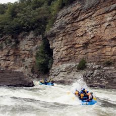
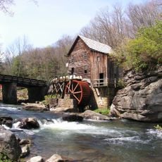
The bridge serves as a gathering point for locals and travelers who stop along the nearby overlooks to take in the view of the gorge. Many visitors combine their trip here with hikes along the rim or white-water rafting trips on the river below.

Practical

The bridge carries U.S. Route 19 across the gorge and remains open year-round for cars, serving about 16,200 vehicles each day. Pedestrians cannot usually walk across, except on one October day each year when the roadway closes to traffic and opens to visitors.

Did you know?

On the third Saturday each October, the bridge becomes a platform for base jumping and rappelling, drawing about 80,000 spectators to the event. During Bridge Day, participants leap from the railing and deploy their parachutes on the way down to the river below.

Location
Inception
October 22, 1977
Official opening
October 22, 1977
Length
924 m
Longest Span
518 m
Made from material
steel
GPS coordinates
38.06889,-81.08259
Latest update
December 12, 2025 22:25

AroundUs brings together thousands of curated places, local tips, and hidden gems, enriched daily by 60,000 contributors worldwide. Discover all places nearby (Fayetteville).

Around this place
Summersville Lake
United States of America

Summersville Lake

24 km
Hawks Nest State Park
United States of America

Hawks Nest State Park

7.2 km
Babcock State Park
United States of America

Babcock State Park

12.8 km
Carnifex Ferry Battlefield State Park
United States of America

Carnifex Ferry Battlefield State Park

20 km
Ace Adventure Resort
United States of America

Ace Adventure Resort

10.8 km
Oak Hill High School
United States of America

Oak Hill High School

10.4 km
Tunney Hunsaker Bridge
United States of America

Tunney Hunsaker Bridge

662 m
Glen Ferris Inn
United States of America

Glen Ferris Inn

14.7 km
Bank of Glen Jean
United States of America

Bank of Glen Jean

16.9 km
Page-Vawter House
United States of America

Page-Vawter House

7.8 km
Camp Washington-Carver Complex
United States of America

Camp Washington-Carver Complex

11.8 km
Altamont Hotel
United States of America

Altamont Hotel

2.5 km
Nicholas County Courthouse
United States of America

Nicholas County Courthouse

29.6 km
Contentment
United States of America

Contentment

7.6 km
Booker T. Washington High School
United States of America

Booker T. Washington High School

29.3 km
E. B. Hawkins House
United States of America

E. B. Hawkins House

2.3 km
Fayetteville Historic District
United States of America

Fayetteville Historic District

2.9 km
Mount Hope Historic District
United States of America

Mount Hope Historic District

21 km
Fayette County Courthouse
United States of America

Fayette County Courthouse

2.5 km
New River Company General Office Building
United States of America

New River Company General Office Building

20.5 km
Dr. John Hughart House
United States of America

Dr. John Hughart House

16.8 km
Earl M. Vickers Bridge
United States of America

Earl M. Vickers Bridge

24.1 km
Glade Creek Grist Mill
United States of America

Glade Creek Grist Mill

15.5 km
Fayette Station Road
United States of America

Fayette Station Road

355 m
Kay Moor
United States of America

Kay Moor

2.8 km
Main Building
United States of America

Main Building

24.5 km
Nuttall Coal Mine Conveyor
United States of America

Nuttall Coal Mine Conveyor

4 km
Thurmond Historic District
United States of America

Thurmond Historic District

12.3 km
Show the full map
« New River Gorge Bridge - Steel arch bridge in Fayetteville, United States » is provided by Around Us (aroundus.com). Images and texts are derived from Wikimedia project under a Creative Commons license. You are allowed to copy, distribute, and modify copies of this page, under the conditions set by the license, as long as this note is clearly visible.

Discover hidden gems everywhere you go!

From secret cafés to breathtaking viewpoints, skip the crowded tourist spots and find places that match your style. Our app makes it easy with voice search, smart filtering, route optimization, and insider tips from travelers worldwide. Download now for the complete mobile experience.

Around Us App Screenshot

A unique approach to discovering new places

Le Figaro

All the places worth exploring

France Info

A tailor-made excursion in just a few clicks

20 Minutes

Around Us
Travel Guide & Maps
Download

Send to your phone

QR Code
1

Open the camera app on your mobile.

2

Point at the QR code with your camera. A notification will appear.

3

Tap the notification to open the link.