Sassafras Mountain

Log in to your account

AroundUs is a community-driven map of interesting places, built by curious explorers like you. It grows with every review, story, and photo you share.
Connect to save your favorite spots, contribute locations, and create personalized routes.
By continuing, you accept our Terms and Conditions and our Privacy Policy
Add to collection
Map
Suggest a change
Share

Sassafras Mountain, Mountain summit in Pickens County, United States

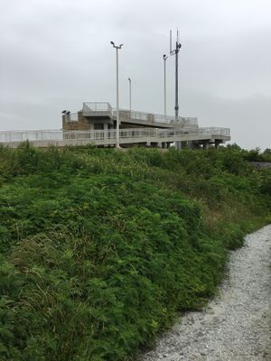
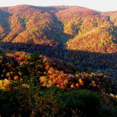
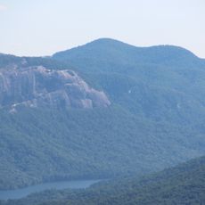
Sassafras Mountain is South Carolina's highest peak at 1,085 meters, offering views that stretch across multiple states from its summit. A paved road and accessible walkway lead to an observation tower where visitors can take in these expansive vistas.

The Conservation Fund acquired roughly 8,000 acres of the mountain from Congressman Charles H. Taylor in 2010, then transferred portions to state management. This acquisition protected the landscape and opened it to public access.

The mountain's name comes from sassafras trees that grow on its lower slopes, reflecting the natural character of the region. These trees shape the landscape and serve as a natural marker for visitors approaching the summit.

The summit is reached via a paved road followed by a 300-foot accessible walkway to the observation tower. The route is straightforward to navigate on foot, and the tower provides a comfortable spot to rest and enjoy the views.

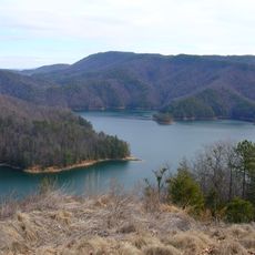
Three distinct watersheds meet at this peak, causing water to flow toward either the Atlantic Ocean or the Gulf of Mexico. This rare hydrological meeting point makes this summit a special location in American geography.

Location: South Carolina

Elevation above the sea: 1,085 m

GPS coordinates: 35.06517,-82.77721

Latest update: December 7, 2025 09:24

Photos
Around this place
Lake Jocassee
United States of America

Lake Jocassee

17.5 km
Table Rock State Park
United States of America

Table Rock State Park

7.3 km
Gorges State Park
United States of America

Gorges State Park

13.1 km
Caesars Head State Park
United States of America

Caesars Head State Park

17.1 km
Bridal Veil Falls
United States of America

Bridal Veil Falls

18.9 km
Turtleback Falls
United States of America

Turtleback Falls

17.5 km
Rainbow Falls
United States of America

Rainbow Falls

17.4 km
Pisgah Astronomical Research Institute
United States of America

Pisgah Astronomical Research Institute

17.3 km
Pinnacle Mountain
United States of America

Pinnacle Mountain

4.8 km
Raven Cliff Falls
United States of America

Raven Cliff Falls

11.5 km
Hagood Mill
United States of America

Hagood Mill

16.2 km
Connestee Falls and Batson Creek Falls
United States of America

Connestee Falls and Batson Creek Falls

11.7 km
Eastatoe Falls
United States of America

Eastatoe Falls

6.3 km
Silvermont
United States of America

Silvermont

18.7 km
St. Philip's Episcopal Church
United States of America

St. Philip's Episcopal Church

19 km
Hillmont
United States of America

Hillmont

18.1 km
Lake Toxaway Methodist Church
United States of America

Lake Toxaway Methodist Church

16.4 km
Charles E. Orr House
United States of America

Charles E. Orr House

19 km
Flem Galloway House
United States of America

Flem Galloway House

10.4 km
Godfrey-Barnette House
United States of America

Godfrey-Barnette House

18.4 km
Roper House Complex
United States of America

Roper House Complex

9.1 km
Civilian Conservation Corps Quarry No. 2
United States of America

Civilian Conservation Corps Quarry No. 2

8.3 km
Royal and Louise Morrow House
United States of America

Royal and Louise Morrow House

18.5 km
William H. Grogan House
United States of America

William H. Grogan House

18.7 km
Main Street Historic District
United States of America

Main Street Historic District

19.1 km
Hanckel-Barclay House
United States of America

Hanckel-Barclay House

15 km
Max and Claire Brombacher House
United States of America

Max and Claire Brombacher House

18.4 km
PARI 26m radio telescope
United States of America

PARI 26m radio telescope

17.3 km
Show the full map
Reviews

Visited this place? Tap the stars to rate it and share your experience / photos with the community! Try now! You can cancel it anytime.

« Sassafras Mountain - Mountain summit in Pickens County, United States » is provided by Around Us (aroundus.com). Images and texts are derived from Wikimedia project under a Creative Commons license. You are allowed to copy, distribute, and modify copies of this page, under the conditions set by the license, as long as this note is clearly visible.

Discover hidden gems everywhere you go!

From secret cafés to breathtaking viewpoints, skip the crowded tourist spots and find places that match your style. Our app makes it easy with voice search, smart filtering, route optimization, and insider tips from travelers worldwide. Download now for the complete mobile experience.

Around Us App Screenshot

A unique approach to discovering new places

Le Figaro

All the places worth exploring

France Info

A tailor-made excursion in just a few clicks

20 Minutes