Holly Springs National Forest

Log in to your account

AroundUs is a community-driven map of interesting places, built by curious explorers like you. It grows with every review, story, and photo you share.
Connect to save your favorite spots, contribute locations, and create personalized routes.
Continue with Google
Continue with Apple
Continue with X
Continue with Facebook
Continue with email
By continuing, you accept our Terms and Conditions and our Privacy Policy
Create an account
Add to collection
Map
Suggest a change
Share

Holly Springs National Forest, National Forest in northern Mississippi, United States.

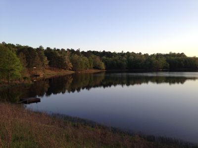
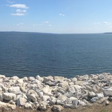
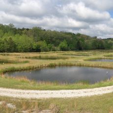
Holly Springs National Forest is a large wooded area across six counties in northern Mississippi, combining pine stands, hardwood forests, lakes, and rolling terrain. The landscape includes several water bodies like Chewalla Lake, Puskus Lake, and Lake Tillatoba alongside dense woodland with varying elevations.

The forest was established in 1936 during the Great Depression, when the Civilian Conservation Corps planted pine trees to prevent soil erosion. This large-scale replanting program reshaped the landscape and remains visible in the forest's composition today.

The forest holds remnants of past settlements and farming communities that reveal how people have lived and worked this land over time. Walking through it, you can sense the long human history woven into the landscape.

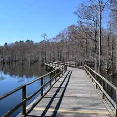
The forest has multiple recreational areas and marked trails through different woodland types, with facilities available at the main lakes. Conditions vary considerably with the seasons, especially during rainy periods and warmer months, so plan accordingly.

Baker's Pond in the northernmost section marks the starting point of the Wolf River, which flows through Tennessee and Mississippi. This small water body gives rise to a river that travels across multiple states.

Location: Mississippi

Inception: June 15, 1936

Operator: United States Forest Service

Website: https://fs.usda.gov/detail/mississippi/about-forest/districts/?cid=stelprdb5209589

GPS coordinates: 34.73330,-89.13330

Latest update: December 6, 2025 17:40

Photos
Discover Hidden Treasures of Mississippi

Mississippi preserves sites that trace the state's history from indigenous settlements through the Civil War and the civil rights movement. The Windsor Ruins stand as remnants of an antebellum mansion, while the Old Capitol Museum documents legislative history. The Mississippi Civil Rights Museum in...

Around this place
Vaught–Hemingway Stadium
United States of America

Vaught–Hemingway Stadium

55.3 km
Rowan Oak
United States of America

Rowan Oak

54.9 km
The Grove
United States of America

The Grove

54.9 km
Graceland Too
United States of America

Graceland Too

28.8 km
Sardis Lake
United States of America

Sardis Lake

70.7 km
Statue of James Meredith
United States of America

Statue of James Meredith

55.2 km
Wall Doxey State Park
United States of America

Wall Doxey State Park

31.7 km
Walter Place
United States of America

Walter Place

29.6 km
United States of America

Lyceum

60.1 km
Lyceum-The Circle Historic District
United States of America

Lyceum-The Circle Historic District

55 km
Lochinvar
United States of America

Lochinvar

58.8 km
Ammadelle
United States of America

Ammadelle

53.6 km
Sally McDonnell Barksdale Honors College
United States of America

Sally McDonnell Barksdale Honors College

54.7 km
Boling-Gatewood House
United States of America

Boling-Gatewood House

28.8 km
University of Mississippi Power House
United States of America

University of Mississippi Power House

55.1 km
Barnard Observatory
United States of America

Barnard Observatory

55 km
University of Mississippi Museum
United States of America

University of Mississippi Museum

54.6 km
Lafayette County Courthouse
United States of America

Lafayette County Courthouse

54 km
University of Mississippi Field Station
United States of America

University of Mississippi Field Station

40.9 km
United States of America

Confederate Monument

55.7 km
Kennon Observatory
United States of America

Kennon Observatory

55.3 km
St. Peter's Episcopal Church
United States of America

St. Peter's Episcopal Church

54.1 km
Oakleigh
United States of America

Oakleigh

28.5 km
Oxford Courthouse Square Historic District
United States of America

Oxford Courthouse Square Historic District

54 km
Judge Bates House
United States of America

Judge Bates House

94.2 km
Houston Carnegie Library
United States of America

Houston Carnegie Library

94 km
Dunvegan
United States of America

Dunvegan

29.3 km
Old Water and Electric Light Plant
United States of America

Old Water and Electric Light Plant

29 km
Show the full map
Reviews

Visited this place? Tap the stars to rate it and share your experience / photos with the community! Try now! You can cancel it anytime.

« Holly Springs National Forest - National Forest in northern Mississippi, United States » is provided by Around Us (aroundus.com). Images and texts are derived from Wikimedia project under a Creative Commons license. You are allowed to copy, distribute, and modify copies of this page, under the conditions set by the license, as long as this note is clearly visible.

Discover hidden gems everywhere you go!

From secret cafés to breathtaking viewpoints, skip the crowded tourist spots and find places that match your style. Our app makes it easy with voice search, smart filtering, route optimization, and insider tips from travelers worldwide. Download now for the complete mobile experience.

Around Us App Screenshot

A unique approach to discovering new places

Le Figaro

All the places worth exploring

France Info

A tailor-made excursion in just a few clicks

20 Minutes