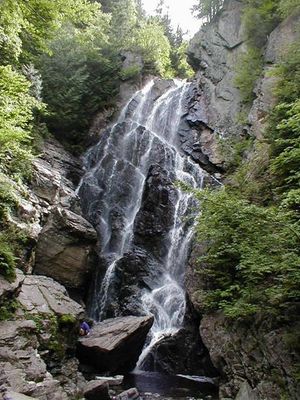
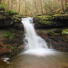
Angel Falls, Waterfall in Franklin County, Maine.
Angel Falls is a waterfall in Franklin County, Maine, that drops roughly 90 feet through a narrow gap in the cliff face while creating multiple tiers of cascading water down Mountain Brook. The water descends in stepped movements, forming a pattern that shifts with the changing flow of water throughout the year.
Angel Falls took shape through ice processes during the last Ice Age, which carved the cliff gaps and cascades. These geological forces created the distinctive structure visible today.
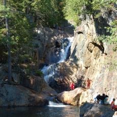
Local hiking groups and nature organizations maintain the trails leading to Angel Falls, ensuring continued public access to this natural formation.
To reach this waterfall, visitors need to cross several streams and navigate forest roads, which requires sturdy footwear and careful footing. Spring brings the strongest water flow, but the path becomes wetter and more slippery at that time.
Water pours through a geometrically precise opening in the rock face that resembles a large rectangular window. This unusual shape gives the waterfall its distinctive look and makes it stand out from other cascades in the region.
Location: Maine
GPS coordinates: 44.78290,-70.70960
Latest update: December 6, 2025 17:43
Maine offers coastal areas, forest landscapes and many historic sites. The region extends from the Atlantic Ocean to wooded mountains inland. Visitors find state parks like Baxter and Acadia, which provide opportunities for hiking and observing wildlife. The coast is lined with lighthouses, including Pemaquid Point and West Quoddy Head. Islands such as Monhegan and Peaks Island lie offshore. Waterfalls like Screw Auger Falls and Angel Falls draw hikers. Lakes such as Moosehead Lake attract people in warmer months. Old military structures like Fort Gorges remain from earlier centuries. Trails lead through areas like Gulf Hagas and Vaughan Woods. The landscape includes beaches at Roque Bluffs and Reid State Park, where sand meets the ocean. Mountain trails at Tumbledown offer views of surrounding valleys. The Carriage Roads on Mount Desert Island provide paths through forests and along lakeshores. Nature areas like Orono Bog Boardwalk allow close views of wetland plants. These places show the variety of terrain Maine contains, from rocky shores to inland wilderness.
Orgonon
22.5 km
Tumbledown Mountain
13.2 km
Saddleback Mountain
23.5 km
Grafton Notch State Park
28.3 km
Smalls Falls
17.4 km
Mount Blue State Park
26.7 km
Baldpate Mountain
24.3 km
Rangeley Lake State Park
18.1 km
Forest Lodge
19.1 km
Saddleback Horn
25.6 km
Umbagog Lake State Park
28.8 km
Merrill-Poor House
16.5 km
Andover Public Library
17.2 km
Lovejoy Bridge
21.2 km
Rumford Public Library
29.2 km
Saddleback Junior
27.9 km
Rumford Municipal Building
29.3 km
Weld Town Hall
24.8 km
Madrid Village Schoolhouse
21.5 km
Rumford Falls Power Company Building
29.5 km
Capt. Joel Whitney House
29.5 km
Rangeley Public Library
20.9 km
Upper Dallas School
22 km
Deacon Hutchins House
26.4 km
Rangeley Trust Company Building
20.8 km
Maine Woods Office
28.9 km
Cascade Stream Gorge Trail
17.6 km
Screw Auger Falls
28 kmVisited this place? Tap the stars to rate it and share your experience / photos with the community! Try now! You can cancel it anytime.
Discover hidden gems everywhere you go!
From secret cafés to breathtaking viewpoints, skip the crowded tourist spots and find places that match your style. Our app makes it easy with voice search, smart filtering, route optimization, and insider tips from travelers worldwide. Download now for the complete mobile experience.
A unique approach to discovering new places❞
— Le Figaro
All the places worth exploring❞
— France Info
A tailor-made excursion in just a few clicks❞
— 20 Minutes