Chest opened
+${chestReward.xp} XP
Explorer
NOUVEAU ×${chestReward.collectible.quantity}
tapez pour fermer
Chest locked

Open chests in the app

Around Us is built for your phone — chests unlock when you walk, explore and capture nearby places.

Enable Location

We need your location to show you interesting places around you

Discover nearby places

Find interesting locations and hidden gems around you

Precise directions

Get accurate directions and distances to places

Your location is never shared with other users. It's only used when you tap the location button.

Log in to your account

Start exploring — it's free

Trusted by 72,967 travelers worldwide

Continue with Google
Continue with Apple
or

We will send you a code to connect

By continuing, you accept our Terms and Conditions and our Privacy Policy

Check your inbox

We've sent a pincode in your inbox. Please enter the code below.

Atsena Otie Key
Discussion Reviews Photo
4.4k Popularity

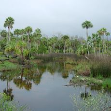
Atsena Otie Key, Historical barrier island near Cedar Key, Florida.

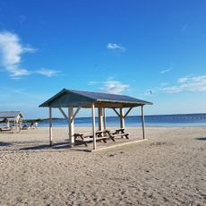
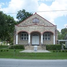
Atsena Otie Key is a barrier island with walking trails through forests of longleaf pines, red bays, and oak trees draped in Spanish moss. The island offers beaches, hiking paths, and a well-preserved cemetery grounds.

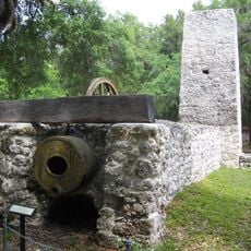
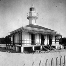
The island was home to a lumber mill operated by pencil makers Eberhard Faber from 1868 to 1896. A hurricane destroyed the facility and ended this industrial chapter of the island.

The cemetery holds marble tombstones of early settlers, showing how people lived here in the early 1900s. This quiet burial ground tells the story of this coastal community's past.

The island is accessible only by boat from Cedar Key. Plan time for the boat journey and bring water and sun protection.

Archaeological excavations in 1999 uncovered a human skeleton more than 2000 years old. This discovery confirms that Native Americans lived here in ancient times.

The community of curious travelers

AroundUs brings together thousands of curated places, local tips, and hidden gems, enriched daily by 60,000 contributors worldwide.

Start exploring
GPS coordinates
29.12247,-83.02679
Latest update
December 11, 2025 11:02
Around this place
Devil's Den
United States of America

Devil's Den

63.6 km
Homosassa Springs Wildlife State Park
United States of America

Homosassa Springs Wildlife State Park

55.8 km
Crystal River Archaeological State Park
United States of America

Crystal River Archaeological State Park

46.6 km
Chassahowitzka National Wildlife Refuge
United States of America

Chassahowitzka National Wildlife Refuge

59.2 km
Crystal River National Wildlife Refuge
United States of America

Crystal River National Wildlife Refuge

49.1 km
Fanning Springs State Park
United States of America

Fanning Springs State Park

52.4 km
Lower Suwannee National Wildlife Refuge
United States of America

Lower Suwannee National Wildlife Refuge

22.8 km
Yulee Sugar Mill Ruins State Historic Site
United States of America

Yulee Sugar Mill Ruins State Historic Site

55.7 km
Goethe State Forest
United States of America

Goethe State Forest

45 km
Cedar Key Museum State Park
United States of America

Cedar Key Museum State Park

3.9 km
Cedar Key Light
United States of America

Cedar Key Light

4.7 km
Fort Island Beach
United States of America

Fort Island Beach

40.6 km
City of Hawkinsville
United States of America

City of Hawkinsville

54.2 km
Coca-Cola Bottling Plant
United States of America

Coca-Cola Bottling Plant

58.6 km
Gilchrist County Courthouse
United States of America

Gilchrist County Courthouse

58.3 km
Bronson Speedway
United States of America

Bronson Speedway

56.5 km
First Baptist Church
United States of America

First Baptist Church

58.4 km
Old Town Elementary School
United States of America

Old Town Elementary School

52.3 km
Dunnellon Boomtown Historic District
United States of America

Dunnellon Boomtown Historic District

55.4 km
Cedar Key Historical Museum
United States of America

Cedar Key Historical Museum

1.7 km
Crystal River Old City Hall
United States of America

Crystal River Old City Hall

49 km
Trenton Church of Christ
United States of America

Trenton Church of Christ

58.2 km
Old Town Methodist Church
United States of America

Old Town Methodist Church

53.6 km
Levy County Courthouse
United States of America

Levy County Courthouse

52.9 km
Crystal River Archaeological State Park
United States of America

Crystal River Archaeological State Park

45.5 km
John A. King House
United States of America

John A. King House

68.2 km
Citizens Bank
United States of America

Citizens Bank

63.5 km
Archer Historical Society Museum
United States of America

Archer Historical Society Museum

66.8 km
Show the full map
Reviews
Share your experience

No review yet

Discussions
Start a discussion...

No discussion yet

« Atsena Otie Key - Historical barrier island near Cedar Key, Florida » is provided by Around Us (aroundus.com). Images and texts are derived from Wikimedia project under a Creative Commons license. You are allowed to copy, distribute, and modify copies of this page, under the conditions set by the license, as long as this note is clearly visible.

Discover hidden gems everywhere you go!

From secret cafés to breathtaking viewpoints, skip the crowded tourist spots and find places that match your style. Our app makes it easy with voice search, smart filtering, route optimization, and insider tips from travelers worldwide. Download now for the complete mobile experience.

Around Us App Screenshot

A unique approach to discovering new places

Le Figaro

All the places worth exploring

France Info

A tailor-made excursion in just a few clicks

20 Minutes

Around Us
Travel Guide & Maps
Download

Send to your phone

QR Code
1

Open the camera app on your mobile.

2

Point at the QR code with your camera. A notification will appear.

3

Tap the notification to open the link.