Enable Location

We need your location to show you interesting places around you

Discover nearby places

Find interesting locations and hidden gems around you

Precise directions

Get accurate directions and distances to places

Your location is never shared with other users. It's only used when you tap the location button.

Au Sable Light

Log in to your account

Start exploring — it's free

Trusted by 65,442 travelers worldwide

Continue with Google
Continue with Apple
or

We will send you a code to connect

By continuing, you accept our Terms and Conditions and our Privacy Policy

Check your inbox

We've sent a pincode in your inbox. Please enter the code below.

Discussion Reviews 1 Photos
4.6k Popularity

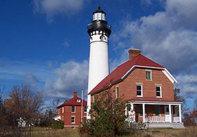
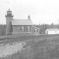
Au Sable Light, Maritime beacon in Burt Township, Michigan, United States.

Au Sable Light is a brick lighthouse on the southern shore of Lake Superior in Michigan, standing about 90 feet (27 m) tall. The tower was built in the Italianate style and features a circular shaft with cast-iron corbels that support the lantern gallery.

The lighthouse was built in 1874 to mark a stretch of Lake Superior's southern shore that had no navigation aids. Over the following decades, additional buildings were added around it to house the keepers and store supplies.

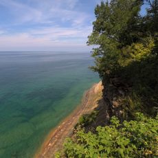
The name Au Sable comes from the French for "sandy water," referring to the nearby river that meets Lake Superior here. Visitors can see how the sandy shoreline and the river mouth together made this stretch of coast a natural landmark for passing sailors.

The lighthouse can only be reached on foot via marked trails from Hurricane River Campground or Log Slide Overlook, so plan for a round trip through forested terrain. Weather along this part of Lake Superior changes quickly, so bring layers even in warmer months.

The lighthouse sits within Pictured Rocks National Lakeshore, which makes it one of the few working lighthouses in the country inside a national park area. Because there is no road access, it remains one of the harder lighthouses to visit in Michigan, and that distance keeps the surroundings almost unchanged from what they looked like a century ago.

The community of curious travelers

AroundUs brings together thousands of curated places, local tips, and hidden gems, enriched daily by 60,000 contributors worldwide.

Start exploring
Location
Inception
1874
Architects
Orlando Metcalfe Poe
Architectural style
Italianate architecture
Height
27 m
Made from material
brick
GPS coordinates
46.67278,-86.13917
Latest update
March 3, 2026 08:14
Around this place
Grand Island National Recreation Area
United States of America

Grand Island National Recreation Area

44.1 km
Seney National Wildlife Refuge
United States of America

Seney National Wildlife Refuge

47.2 km
Grand Island East Channel Light
United States of America

Grand Island East Channel Light

44.2 km
Munising Falls
United States of America

Munising Falls

46.2 km
129
United States of America

129

55.9 km
Pickle Barrel House
United States of America

Pickle Barrel House

11.8 km
Miners Falls
United States of America

Miners Falls

37.2 km
Sable Falls
United States of America

Sable Falls

9.6 km
Wagner Falls Scenic Site
United States of America

Wagner Falls Scenic Site

50.2 km
Wagner Falls
United States of America

Wagner Falls

50.9 km
Bridalveil Falls
United States of America

Bridalveil Falls

34.6 km
Tannery Falls
United States of America

Tannery Falls

47.1 km
Onota, Au Train Township, Michigan
United States of America

Onota, Au Train Township, Michigan

50.5 km
Munising Front Range Light
United States of America

Munising Front Range Light

49.2 km
Grand Island North Light
United States of America

Grand Island North Light

43.2 km
Grand Island Harbor Rear Range Light
United States of America

Grand Island Harbor Rear Range Light

49.8 km
Munising Rear Range Light
United States of America

Munising Rear Range Light

49.5 km
Alger Falls
United States of America

Alger Falls

49.9 km
Memorial Falls
United States of America

Memorial Falls

46.9 km
Beaver Basin Wilderness
United States of America

Beaver Basin Wilderness

18.6 km
Schoolcraft Furnace Site
United States of America

Schoolcraft Furnace Site

46.2 km
Lobb House
United States of America

Lobb House

49.2 km
Grand Island Harbor Front Range Light
United States of America

Grand Island Harbor Front Range Light

49.7 km
Chapel Rock
United States of America

Chapel Rock

26.7 km
Grand Marais Harbor of Refuge Outer Light
United States of America

Grand Marais Harbor of Refuge Outer Light

12.8 km
Munising School Public Library
United States of America

Munising School Public Library

49.2 km
Pictured Rocks
United States of America

Pictured Rocks

30.9 km
J Pool
United States of America

J Pool

44.5 km
Show the full map
Reviews
Share your experience

No review yet

Discussions
Start a discussion...

No discussion yet

« Au Sable Light - Maritime beacon in Burt Township, Michigan, United States » is provided by Around Us (aroundus.com). Images and texts are derived from Wikimedia project under a Creative Commons license. You are allowed to copy, distribute, and modify copies of this page, under the conditions set by the license, as long as this note is clearly visible.

Discover hidden gems everywhere you go!

From secret cafés to breathtaking viewpoints, skip the crowded tourist spots and find places that match your style. Our app makes it easy with voice search, smart filtering, route optimization, and insider tips from travelers worldwide. Download now for the complete mobile experience.

Around Us App Screenshot

A unique approach to discovering new places

Le Figaro

All the places worth exploring

France Info

A tailor-made excursion in just a few clicks

20 Minutes

Around Us
Travel Guide & Maps
Download

Send to your phone

QR Code
1

Open the camera app on your mobile.

2

Point at the QR code with your camera. A notification will appear.

3

Tap the notification to open the link.