Enable Location

We need your location to show you interesting places around you

Discover nearby places

Find interesting locations and hidden gems around you

Precise directions

Get accurate directions and distances to places

Your location is never shared with other users. It's only used when you tap the location button.

Birmingham Bridge

Log in to your account

Start exploring — it's free

Trusted by 62,556 travelers worldwide

Continue with Google
Continue with Apple
or

We will send you a code to connect

By continuing, you accept our Terms and Conditions and our Privacy Policy

Check your inbox

We've sent a pincode in your inbox. Please enter the code below.

Birmingham Bridge

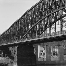
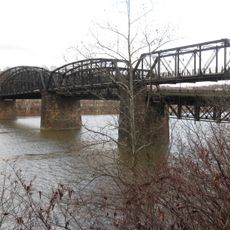
Birmingham Bridge, Road bridge in Pittsburgh, United States

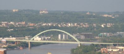
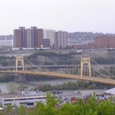
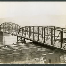
Birmingham Bridge is a road bridge across the Monongahela River with six traffic lanes and a pedestrian pathway on the downstream side. The structure spans between East Carson Street on the South Side and Fifth and Forbes Avenues, linking downtown neighborhoods and commercial districts.

Construction finished in 1976, replacing the earlier South 22nd Street Bridge. The Pennsylvania General Assembly officially gave it the name Birmingham in March 1977.

The name honors the English city of Birmingham and recalls a former Pittsburgh neighborhood that merged into the South Side. Walking across the bridge, you can see how the surrounding area reflects this historical connection through its street names and local character.

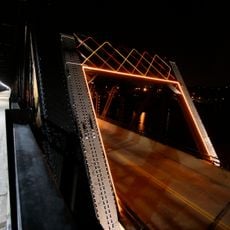
The bridge is straightforward to cross on foot or by car, with good lighting and a wide pedestrian path for safety. Daytime visits offer the clearest river views and most predictable crossing conditions.

The southern approach features unused concrete ramp stubs, leftovers from an abandoned inner-city belt highway project. These remnants stand as physical reminders of a mid-century urban planning vision that was never fully built.

The community of curious travelers

AroundUs brings together thousands of curated places, local tips, and hidden gems, enriched daily by 60,000 contributors worldwide.

Start exploring
Location
Inception
September 2, 1977
GPS coordinates
40.43340,-79.97350
Latest update
December 9, 2025 18:41
Around this place
Hot Metal Bridge
United States of America

Hot Metal Bridge

1.2 km
UPMC Cooper Fieldhouse
United States of America

UPMC Cooper Fieldhouse

1.3 km
Fitzgerald Field House
United States of America

Fitzgerald Field House

1.4 km
South Tenth Street Bridge
United States of America

South Tenth Street Bridge

1.3 km
Trees Hall
United States of America

Trees Hall

1.4 km
Salk Hall
United States of America

Salk Hall

1.4 km
Fifth Avenue High School
United States of America

Fifth Avenue High School

810 m
Lothrop Hall
United States of America

Lothrop Hall

1.5 km
Forbes Hall
United States of America

Forbes Hall

1.4 km
Washington Plaza
United States of America

Washington Plaza

1.4 km
Brady Street Bridge
United States of America

Brady Street Bridge

0 m
New Granada Theater
United States of America

New Granada Theater

1.3 km
Saint Michael's Roman Catholic Church & Rectory
United States of America

Saint Michael's Roman Catholic Church & Rectory

1.3 km
Paramount Film Exchange
United States of America

Paramount Film Exchange

748 m
Fort Pitt Incline
United States of America

Fort Pitt Incline

1.3 km
South Side High School
United States of America

South Side High School

1.5 km
South Side Market Building
United States of America

South Side Market Building

1.2 km
St. Agnes Church
United States of America

St. Agnes Church

904 m
Pittsburgh Mercantile Company Building
United States of America

Pittsburgh Mercantile Company Building

815 m
St. Peter's Episcopal Church
United States of America

St. Peter's Episcopal Church

987 m
Croatian Fraternal Union Building
United States of America

Croatian Fraternal Union Building

1.3 km
Bedford School
United States of America

Bedford School

1.4 km
Garrison Foundry-Mackintosh Hemphill Company Offices
United States of America

Garrison Foundry-Mackintosh Hemphill Company Offices

1.4 km
Birmingham Public School
United States of America

Birmingham Public School

1.1 km
South Side Branch of the Carnegie Library of Pittsburgh
United States of America

South Side Branch of the Carnegie Library of Pittsburgh

528 m
Samuel F.B. Morse School
United States of America

Samuel F.B. Morse School

765 m
Hot Metal Bridge
United States of America

Hot Metal Bridge

1.2 km
1904 South Tenth Street Bridge
United States of America

1904 South Tenth Street Bridge

1.3 km
Show the full map
« Birmingham Bridge - Road bridge in Pittsburgh, United States » is provided by Around Us (aroundus.com). Images and texts are derived from Wikimedia project under a Creative Commons license. You are allowed to copy, distribute, and modify copies of this page, under the conditions set by the license, as long as this note is clearly visible.

Discover hidden gems everywhere you go!

From secret cafés to breathtaking viewpoints, skip the crowded tourist spots and find places that match your style. Our app makes it easy with voice search, smart filtering, route optimization, and insider tips from travelers worldwide. Download now for the complete mobile experience.

Around Us App Screenshot

A unique approach to discovering new places

Le Figaro

All the places worth exploring

France Info

A tailor-made excursion in just a few clicks

20 Minutes

Around Us
Travel Guide & Maps
Download

Send to your phone

QR Code
1

Open the camera app on your mobile.

2

Point at the QR code with your camera. A notification will appear.

3

Tap the notification to open the link.