Chest opened
+${chestReward.xp} XP
Explorer
NOUVEAU ×${chestReward.collectible.quantity}
tapez pour fermer
Chest locked

Open chests in the app

Around Us is built for your phone — chests unlock when you walk, explore and capture nearby places.

Enable Location

We need your location to show you interesting places around you

Discover nearby places

Find interesting locations and hidden gems around you

Precise directions

Get accurate directions and distances to places

Your location is never shared with other users. It's only used when you tap the location button.

Log in to your account

Start exploring — it's free

Trusted by 72,883 travelers worldwide

Continue with Google
Continue with Apple
or

We will send you a code to connect

By continuing, you accept our Terms and Conditions and our Privacy Policy

Check your inbox

We've sent a pincode in your inbox. Please enter the code below.

Clay-Battelle High School
Discussion Reviews Photo
1.9k Popularity

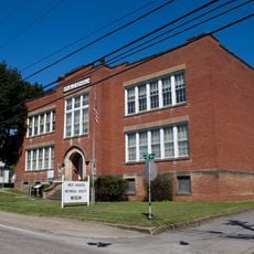
Clay-Battelle High School, Public high school in Monongalia County, United States.

Clay-Battelle High School is a public secondary institution in Monongalia County, West Virginia, with classrooms, laboratory facilities, athletic fields, and a modern gymnasium. The campus provides students with dedicated spaces for academic learning and extracurricular pursuits.

The school was established in 1939 through the merger of three local institutions with support from a federal works program. This consolidation brought together educational facilities from different neighboring communities.

The school colors, navy and gray, reference its location near the Mason-Dixon line, which marked the division between Northern and Southern states.

The campus is located near Blacksville, West Virginia, and is accessible to students from the surrounding area. Visitors should be aware this is an active school facility and should respect normal school hours.

The school is named after Henry Clay, a prominent American statesman, and Gordon Battelle, both figures connected to the educational heritage of the region. These names reflect the importance of both individuals to the local communities served.

The community of curious travelers

AroundUs brings together thousands of curated places, local tips, and hidden gems, enriched daily by 60,000 contributors worldwide.

Start exploring
GPS coordinates
39.71984,-80.22318
Latest update
December 14, 2025 11:23
Around this place
Mason and Dixon Survey Terminal Point
United States of America

Mason and Dixon Survey Terminal Point

9 km
Earl L. Core Arboretum
United States of America

Earl L. Core Arboretum

22.6 km
Opekiska Lock and Dam
United States of America

Opekiska Lock and Dam

22.9 km
Dents Run Covered Bridge
United States of America

Dents Run Covered Bridge

19 km
John Corbley Farm
United States of America

John Corbley Farm

20.6 km
Star City Bridge
United States of America

Star City Bridge

21 km
King Covered Bridge
United States of America

King Covered Bridge

5.9 km
Richard T. Foley Site
United States of America

Richard T. Foley Site

18.3 km
Miller Hall
United States of America

Miller Hall

20.2 km
Hanna Hall
United States of America

Hanna Hall

20.2 km
Fish Creek Covered Bridge
United States of America

Fish Creek Covered Bridge

20.3 km
White Covered Bridge
United States of America

White Covered Bridge

17.5 km
Charles Grant Heasley House
United States of America

Charles Grant Heasley House

20.2 km
Neils Red Covered Bridge
United States of America

Neils Red Covered Bridge

20.6 km
Hamilton-Ely Farmstead
United States of America

Hamilton-Ely Farmstead

13.7 km
Wilson School
United States of America

Wilson School

23.6 km
Bridge in Franklin Township
United States of America

Bridge in Franklin Township

19.7 km
Scott Covered Bridge
United States of America

Scott Covered Bridge

20.6 km
Greene Hills Farm
United States of America

Greene Hills Farm

20.6 km
George Pinkney Morgan House
United States of America

George Pinkney Morgan House

23.5 km
George West Gordon Farm
United States of America

George West Gordon Farm

15.7 km
Shriver Covered Bridge
United States of America

Shriver Covered Bridge

15.5 km
Nettie Woods Covered Bridge
United States of America

Nettie Woods Covered Bridge

16 km
Waynesburg Historic District
United States of America

Waynesburg Historic District

20 km
Mannington Historic District
United States of America

Mannington Historic District

23.7 km
D.I.B. Anderson Farm
United States of America

D.I.B. Anderson Farm

22.3 km
Thomas Kent, Jr., Farm
United States of America

Thomas Kent, Jr., Farm

17.9 km
Greene County Museum
United States of America

Greene County Museum

20.6 km
Show the full map
Reviews
Share your experience

No review yet

Discussions
Start a discussion...

No discussion yet

« Clay-Battelle High School - Public high school in Monongalia County, United States » is provided by Around Us (aroundus.com). Images and texts are derived from Wikimedia project under a Creative Commons license. You are allowed to copy, distribute, and modify copies of this page, under the conditions set by the license, as long as this note is clearly visible.

Discover hidden gems everywhere you go!

From secret cafés to breathtaking viewpoints, skip the crowded tourist spots and find places that match your style. Our app makes it easy with voice search, smart filtering, route optimization, and insider tips from travelers worldwide. Download now for the complete mobile experience.

Around Us App Screenshot

A unique approach to discovering new places

Le Figaro

All the places worth exploring

France Info

A tailor-made excursion in just a few clicks

20 Minutes

Around Us
Travel Guide & Maps
Download

Send to your phone

QR Code
1

Open the camera app on your mobile.

2

Point at the QR code with your camera. A notification will appear.

3

Tap the notification to open the link.