Chest opened
+${chestReward.xp} XP
Explorer
NOUVEAU ×${chestReward.collectible.quantity}
tapez pour fermer
Chest locked

Open chests in the app

Around Us is built for your phone — chests unlock when you walk, explore and capture nearby places.

Enable Location

We need your location to show you interesting places around you

Discover nearby places

Find interesting locations and hidden gems around you

Precise directions

Get accurate directions and distances to places

Your location is never shared with other users. It's only used when you tap the location button.

Civil War defenses of Washington, D.C.

Log in to your account

Start exploring — it's free

Trusted by 73,103 travelers worldwide

Continue with Google
Continue with Apple
or

We will send you a code to connect

By continuing, you accept our Terms and Conditions and our Privacy Policy

Check your inbox

We've sent a pincode in your inbox. Please enter the code below.

Discussion Reviews 1 Photos
13.5k Popularity

Civil War defenses of Washington, D.C., Military fortifications in Washington D.C., United States.

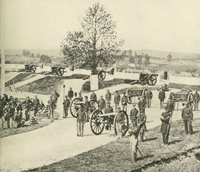
The Civil War defenses of Washington are a network of forts and batteries spread across Maryland and Virginia around the federal capital. The system consists of numerous preserved sites with earthworks, trenches, and foundations that show how thoroughly the region was fortified.

These fortifications were built between 1861 and 1865 as the Union rapidly constructed extensive defenses to protect the capital from Confederate forces. The project represented one of the war's largest engineering efforts and demonstrated the determination to keep the seat of government secure.

These fortifications shaped how people thought about protecting their capital and remain visible reminders of wartime anxiety in the landscape. Walking among the earthworks, visitors sense how completely military concerns dominated the region during those years.

Visitors can explore multiple preserved fort sites, some located in city parks and free to enter, while others offer regular guided tours. Comfortable shoes are recommended since the terrain is hilly and paths cross over earthworks and old trenches.

The system included a network of military roads connecting all the forts, allowing troops to move quickly between defensive positions. Many of these roads remain visible today and often follow modern streets, revealing how strategically the fortifications were planned.

The community of curious travelers

AroundUs brings together thousands of curated places, local tips, and hidden gems, enriched daily by 60,000 contributors worldwide.

Start exploring
Location
Location
Location
Location
GPS coordinates
38.86667,-76.95167
Latest update
February 8, 2026 09:32
Around this place
Anacostia
United States of America

Anacostia

2.8 km
Congressional Cemetery
United States of America

Congressional Cemetery

2.7 km
Frederick Douglass National Historic Site
United States of America

Frederick Douglass National Historic Site

2.9 km
Southeast
United States of America

Southeast

2 km
D.C. Jail
United States of America

D.C. Jail

2.8 km
United States of America

Paul E. Garber Preservation, Restoration, and Storage Facility

2.9 km
Anacostia Community Museum
United States of America

Anacostia Community Museum

2.4 km
The Big Chair
United States of America

The Big Chair

3.3 km
Suitland-Silver Hill
United States of America

Suitland-Silver Hill

3.1 km
Fort Dupont Park
United States of America

Fort Dupont Park

1.2 km
Anacostia Historic District
United States of America

Anacostia Historic District

2.8 km
Dupont Park
United States of America

Dupont Park

1.2 km
Benning
United States of America

Benning

2.9 km
Benning Ridge
United States of America

Benning Ridge

2 km
Fairfax Village
United States of America

Fairfax Village

366 m
Fort Stanton
United States of America

Fort Stanton

2.3 km
Public Vault at the Congressional Cemetery
United States of America

Public Vault at the Congressional Cemetery

2.9 km
Whitney Young Memorial Bridge
United States of America

Whitney Young Memorial Bridge

2.8 km
Francis A. Gregory Neighborhood Library
United States of America

Francis A. Gregory Neighborhood Library

298 m
John Philip Sousa Junior High School
United States of America

John Philip Sousa Junior High School

1.9 km
Gallinger Municipal Hospital Psychopathic Ward
United States of America

Gallinger Municipal Hospital Psychopathic Ward

3 km
Anacostia Railroad Bridge
United States of America

Anacostia Railroad Bridge

2.3 km
Alexander Dallas Bache Monument
United States of America

Alexander Dallas Bache Monument

2.8 km
Pennsylvania Avenue Bridge
United States of America

Pennsylvania Avenue Bridge

2.6 km
Benning / Dorothy I. Height Neighborhood Library
United States of America

Benning / Dorothy I. Height Neighborhood Library

3.1 km
Anacostia Neighborhood Library
United States of America

Anacostia Neighborhood Library

2.3 km
John Philip Sousa Bridge
United States of America

John Philip Sousa Bridge

2.5 km
Latrobe cenotaphs
United States of America

Latrobe cenotaphs

2.8 km
Show the full map
Reviews
Share your experience

No review yet

Discussions
Start a discussion...

No discussion yet

« Civil War defenses of Washington, D.C. - Military fortifications in Washington D.C., United States » is provided by Around Us (aroundus.com). Images and texts are derived from Wikimedia project under a Creative Commons license. You are allowed to copy, distribute, and modify copies of this page, under the conditions set by the license, as long as this note is clearly visible.

Discover hidden gems everywhere you go!

From secret cafés to breathtaking viewpoints, skip the crowded tourist spots and find places that match your style. Our app makes it easy with voice search, smart filtering, route optimization, and insider tips from travelers worldwide. Download now for the complete mobile experience.

Around Us App Screenshot

A unique approach to discovering new places

Le Figaro

All the places worth exploring

France Info

A tailor-made excursion in just a few clicks

20 Minutes

Around Us
Travel Guide & Maps
Download

Send to your phone

QR Code
1

Open the camera app on your mobile.

2

Point at the QR code with your camera. A notification will appear.

3

Tap the notification to open the link.