Chest opened
+${chestReward.xp} XP
Explorer
NOUVEAU ×${chestReward.collectible.quantity}
tapez pour fermer
Chest locked

Open chests in the app

Around Us is built for your phone — chests unlock when you walk, explore and capture nearby places.

Enable Location

We need your location to show you interesting places around you

Discover nearby places

Find interesting locations and hidden gems around you

Precise directions

Get accurate directions and distances to places

Your location is never shared with other users. It's only used when you tap the location button.

Log in to your account

Start exploring — it's free

Trusted by 72,992 travelers worldwide

Continue with Google
Continue with Apple
or

We will send you a code to connect

By continuing, you accept our Terms and Conditions and our Privacy Policy

Check your inbox

We've sent a pincode in your inbox. Please enter the code below.

Crown Point State Historic Site
Discussion Reviews Photo
4.7k Popularity

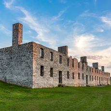
Crown Point State Historic Site, Military fortress ruins in Crown Point, New York.

Crown Point State Historic Site preserves the ruins of two colonial fortifications along Lake Champlain with stone walls and defensive structures built centuries ago. Both fortifications show different construction styles from different periods of European settlement.

French forces built Fort St. Frederic in 1734 as an outpost with a four-story stone octagon and cannons for defense. British forces occupied the fortification in 1759 and later modified it to suit their military needs.

The place shows how French, British, and American forces shaped the region through their struggles for control. Visitors can walk through the ruins and understand how military conflicts changed the lives of people living here.

Visiting is best during daytime hours when the ruins and water views are clearly visible. The grounds are mostly open to walk through, but sturdy shoes are needed for uneven and rocky paths.

An 1858 lighthouse stands on the grounds with a bronze statue honoring Samuel Champlain nearby. This combination of lighthouse and memorial creates a distinctive landmark overlooking the lake.

The community of curious travelers

AroundUs brings together thousands of curated places, local tips, and hidden gems, enriched daily by 60,000 contributors worldwide.

Start exploring
Location
GPS coordinates
44.02870,-73.42950
Latest update
December 10, 2025 20:06
Around this place
Fort Crown Point
United States of America

Fort Crown Point

139 m
Lake Champlain Bridge
United States of America

Lake Champlain Bridge

652 m
Lake Champlain Bridge
United States of America

Lake Champlain Bridge

652 m
Snake Mountain
United States of America

Snake Mountain

12.5 km
Fort Saint-Frédéric
United States of America

Fort Saint-Frédéric

139 m
Crown Point Light
United States of America

Crown Point Light

649 m
Ironville Historic District
United States of America

Ironville Historic District

14.6 km
Grand Isle State Park
United States of America

Grand Isle State Park

18.3 km
Southern Vermont Arts Center
United States of America

Southern Vermont Arts Center

18.5 km
Barber's Point Light
United States of America

Barber's Point Light

14.1 km
Essex County Fairgrounds
United States of America

Essex County Fairgrounds

17.6 km
John Strong Mansion Museum
United States of America

John Strong Mansion Museum

3.2 km
Addison Baptist Church
United States of America

Addison Baptist Church

12.1 km
Shoreham Congregational Church
United States of America

Shoreham Congregational Church

18.2 km
Wesleyan Methodist Church
United States of America

Wesleyan Methodist Church

17.6 km
Sherman Free Library
United States of America

Sherman Free Library

3.2 km
Moriah Town Office Building
United States of America

Moriah Town Office Building

3.5 km
Witherbee Memorial Hall
United States of America

Witherbee Memorial Hall

10.3 km
Camp Dudley Road Historic District
United States of America

Camp Dudley Road Historic District

14 km
Lake View Grange No. 970
United States of America

Lake View Grange No. 970

17.5 km
District Six Schoolhouse
United States of America

District Six Schoolhouse

15.2 km
Paris and Anna Fletcher House
United States of America

Paris and Anna Fletcher House

10.5 km
Central Powerhouse
United States of America

Central Powerhouse

11 km
Cotton Free Library
United States of America

Cotton Free Library

17.6 km
House at 215 School Street
United States of America

House at 215 School Street

17.7 km
District School No. 1
United States of America

District School No. 1

12.1 km
Witherell Farm
United States of America

Witherell Farm

17.5 km
John Hamilton Farmstead
United States of America

John Hamilton Farmstead

13.1 km
Show the full map
Reviews
Share your experience

No review yet

Discussions
Start a discussion...

No discussion yet

« Crown Point State Historic Site - Military fortress ruins in Crown Point, New York » is provided by Around Us (aroundus.com). Images and texts are derived from Wikimedia project under a Creative Commons license. You are allowed to copy, distribute, and modify copies of this page, under the conditions set by the license, as long as this note is clearly visible.

Discover hidden gems everywhere you go!

From secret cafés to breathtaking viewpoints, skip the crowded tourist spots and find places that match your style. Our app makes it easy with voice search, smart filtering, route optimization, and insider tips from travelers worldwide. Download now for the complete mobile experience.

Around Us App Screenshot

A unique approach to discovering new places

Le Figaro

All the places worth exploring

France Info

A tailor-made excursion in just a few clicks

20 Minutes

Around Us
Travel Guide & Maps
Download

Send to your phone

QR Code
1

Open the camera app on your mobile.

2

Point at the QR code with your camera. A notification will appear.

3

Tap the notification to open the link.