Cao Bằng, city in Vietnam
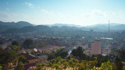
Cao Bằng is a provincial city in northeastern Vietnam, set in a valley surrounded by limestone mountains close to the Chinese border. The city sits along the Bang Giang River and serves as the main gateway for visitors heading to the wider province, including Ban Gioc waterfall and Pac Bo cave.
The area around Cao Bằng was a base for Vietnamese revolutionaries in the mid-20th century, and Ho Chi Minh himself sheltered in caves near Pac Bo before leading the fight for independence. In 1979, the city was heavily damaged during the Sino-Vietnamese War and later rebuilt from the ground up.
The Tày and Nùng peoples have long lived in the surrounding villages, and their presence shapes what visitors see in the local markets: handwoven cloth, wicker baskets, and traditional dress that varies from one valley to the next. Each community keeps its own festivals and food traditions, which sometimes spill into the streets of the city itself.
The dry season, from October to March, is generally the most comfortable time to visit, as the roads to outlying sites are easier to travel. A motorbike is by far the most practical way to get around the province once you arrive, since many of the main attractions lie well outside the city center.
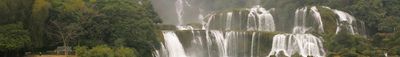
The Ban Gioc waterfall, one of the main draws of the province, sits directly on the border with China, meaning that standing at the base you can see both countries at once. Local fishermen still use wooden rafts to cross the river near the falls, a sight that has changed little over generations.
The community of curious travelers
AroundUs brings together thousands of curated places, local tips, and hidden gems, enriched daily by 60,000 contributors worldwide.