
Thượng Lâm, Landgemeinde in Vietnam
Location: Lâm Bình
Elevation above the sea: 387 m
GPS coordinates: 22.46056,105.32861
Latest update: April 27, 2025 19:32

Hùng Temple
121.9 km
Ban Gioc–Detian Falls
149.8 km
Nui Coc Lake
105.1 km
Bao Ha Temple
105.6 km
Tam Đảo
106.6 km
Friendship Pass
152.4 km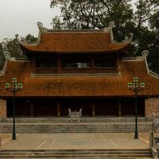
Son Tay Ancient Citadel
148.3 km
Tam Dao National Park
107.5 km
Ba Bể National Park
30.1 km
Xuan Son National Park
151.5 km
Viet Tri Stadium
128.9 km
牡宜遗址
137.2 km
Nguom Ngao Cave
147.8 km
Tra Linh checkpoint
112.1 km
Cốc Lếu Bridge
140 km
Longbang Port
112.1 km
Thanh Chuong Viet Palace
140.6 km
Vat Bridge
139.8 km
Pho Lu Bridge
119.2 km
Kim Thanh Bridge
142.9 km
Thác Bà Lake
87.5 km
河口海关旧址
140.5 km
大王岩岩画
97.8 km
Ha Giang provincial museum
54.4 km
同盟会河口起义纪念馆
140.5 km
保兴桥
115.1 km
Hoang Su Phi Terraced Rice Fields
74.1 km
Muong Hoa Valley
150.3 kmReviews
Visited this place? Tap the stars to rate it and share your experience / photos with the community! Try now! You can cancel it anytime.
Discover hidden gems everywhere you go!
From secret cafés to breathtaking viewpoints, skip the crowded tourist spots and find places that match your style. Our app makes it easy with voice search, smart filtering, route optimization, and insider tips from travelers worldwide. Download now for the complete mobile experience.

A unique approach to discovering new places❞
— Le Figaro
All the places worth exploring❞
— France Info
A tailor-made excursion in just a few clicks❞
— 20 Minutes