See the monuments around you in AROpen chests in the app
Around Us is built for your phone — point your camera at the streets and discover the monuments and places around you in augmented reality.Around Us is built for your phone — chests unlock when you walk, explore and capture nearby places.
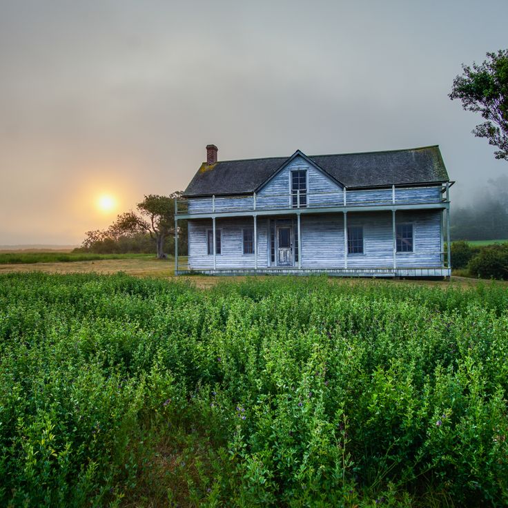
Washington holds far more than the well-known attractions of Seattle and Mount Rainier. Across the state, dozens of less-visited sites offer insight into the region's geological history, military past, and natural diversity. From waterfalls to ancient forests to historic lighthouses and military fortifications, Washington presents a substantial range of landscapes and cultural sites.
Palouse Falls in Franklin County drops 198 feet (60 meters) into a basalt gorge, while Cape Flattery at the northwesternmost point of the continental United States looks out over jagged cliffs and the open Pacific. Ape Caves in Skamania County is one of the longest lava tube systems in the country, and Beacon Rock rises 848 feet (260 meters) above the Columbia River. The Trail of the Patriarchs leads through centuries-old Douglas firs and cedars, and Deception Pass Bridge connects Whidbey Island to the mainland via a 180-foot (55-meter) steel structure from 1935.
Fort Worden in Port Townsend served as a coastal defense installation, and the Wing Luke Museum in Seattle documents the Asian American history of the Pacific Northwest. Dry Falls in Grant County shows the remains of an Ice Age waterfall that was once wider than Niagara Falls. Mima Mounds in Thurston County forms a field of hundreds of symmetrical earth mounds whose formation continues to be scientifically debated. These sites offer practical alternatives to the crowded main attractions and allow for deeper engagement with Washington's natural and historical features.
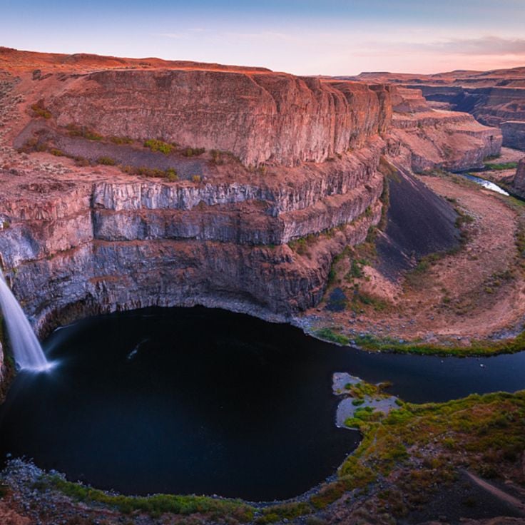
Palouse Falls drops 198 feet (60 meters) into a basalt canyon in eastern Washington. The waterfall on the Palouse River sits approximately 4 miles (6 kilometers) upstream from where the river meets the Snake River. Water flows over a volcanic rock wall exposed during Ice Age floods at the end of the last glacial period. A park area with viewpoints provides access to the canyon, where trails lead to various positions along the cliffs. The falls carry the most water during spring snowmelt, when the river reaches its maximum volume.
This cape marks the northwesternmost point of the contiguous United States on the Olympic Peninsula. The half-mile trail through temperate rainforest leads to viewing platforms perched above cliffs overlooking the Pacific Ocean and the Strait of Juan de Fuca. Seabirds nest on offshore rock formations while gray whales pass during spring and fall migrations. The area sits on Makah tribal land and requires a tribal access permit.
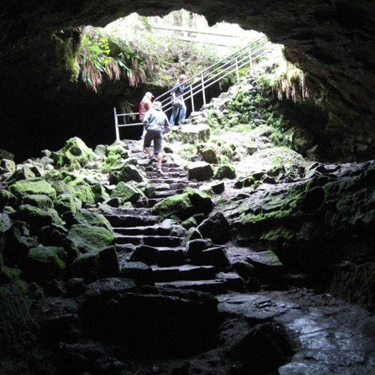
The Ape Caves formed 2,000 years ago from a Mount St. Helens lava flow and extend through two miles of underground passages. These lava tubes offer visitors the chance to walk through volcanic formations created as the molten rock cooled and drained. The cave system lies in southwestern Washington and requires flashlights and sturdy footwear, as no lighting is installed. Access points along the trail lead into different sections, with some areas featuring low ceilings and uneven floors.
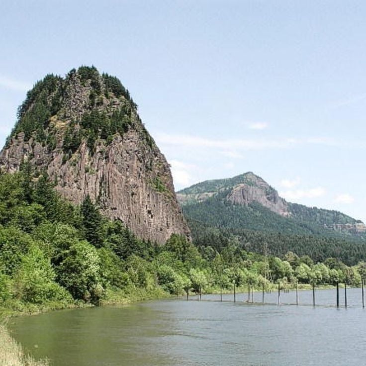
Beacon Rock rises 848 feet above the Columbia River as a prominent volcanic monolith within the Columbia River Gorge. This basalt formation emerged approximately 57,000 years ago as the core of a volcano whose outer layers eroded during the Missoula Floods. A trail with 52 switchbacks ascends to the summit through wooden walkways and rock-cut passages, offering views across the river and surrounding valleys. The path was constructed between 1915 and 1918 by Henry Biddle as part of his effort to preserve the rock from quarrying proposals.
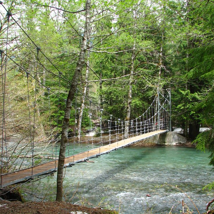
The trail passes through a forest of Douglas firs and western red cedars exceeding 1,000 years in age, among the oldest trees in Mount Rainier National Park. The Patriarch Grove Trail extends roughly half a mile (0.8 kilometers) through the Ohanapecosh area, showcasing specimens with trunk diameters reaching 25 feet (7.6 meters). This forest provides insight into conifer growth under optimal conditions in the temperate rainforest environment of the Cascade Range. The path crosses a suspension bridge over the Ohanapecosh River and winds through one of the last intact old growth stands remaining in Washington State.
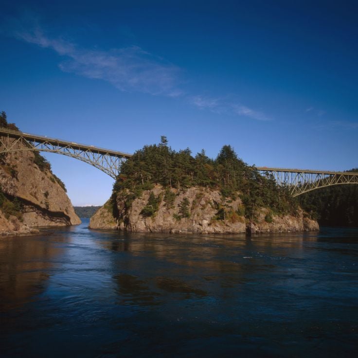
This steel arch bridge completed in 1935 spans a 180-foot (55-meter) channel with strong tidal currents between Whidbey Island and Fidalgo Island in northern Puget Sound. The bridge carries State Route 20 about 180 feet (55 meters) above the water and ranks among the most photographed bridges in the Pacific Northwest. Two parallel steel arches support the roadway, while pedestrian walkways on either side provide access to viewpoints over the water and forested islands. Trails beneath the bridge lead to small beaches where visitors can view the structure from below.
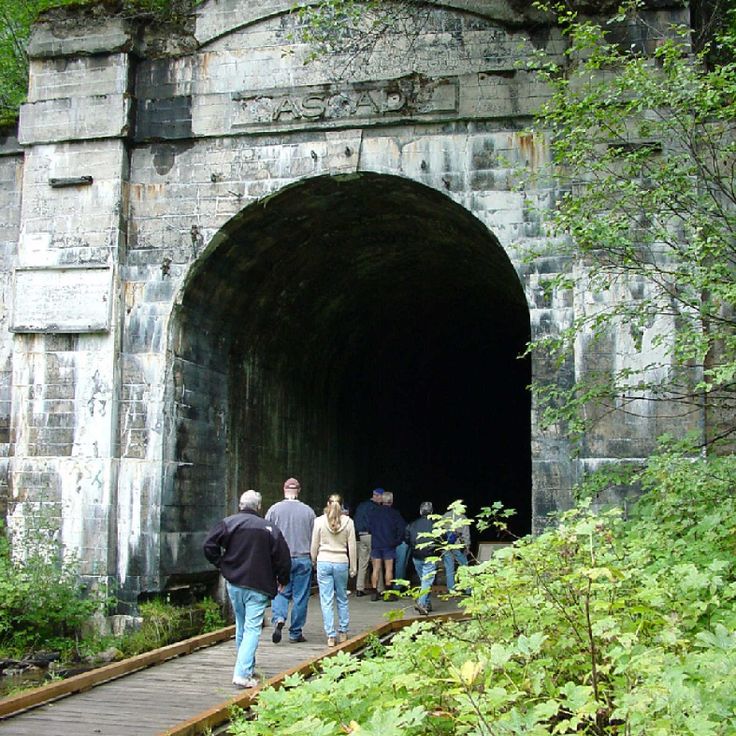
The Iron Goat Trail follows 6.2 miles (10 kilometers) of an abandoned railroad grade dating from 1893 through the Cascade Mountains. The route passes through several tunnels and snowshed galleries originally built to protect trains from avalanches. Interpretive signs document the history of the Great Northern Railway and the engineering challenges of mountain railroading. The mostly level path provides access to remnants of early Washington transportation infrastructure.
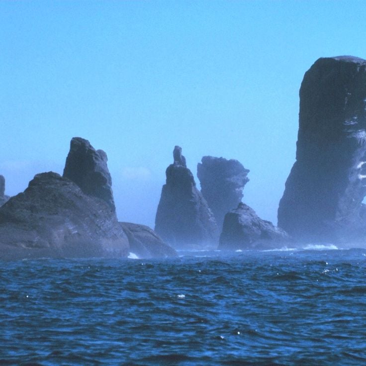
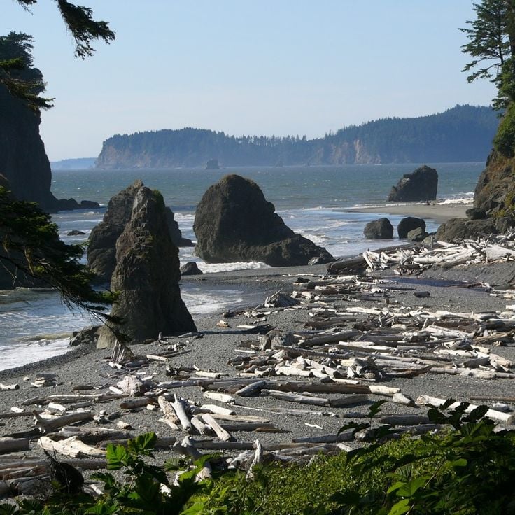
This coastal section sits along the Olympic Peninsula and shows several offshore rock formations that create tide pools with sea stars, anemones and small crabs during low tide. Ruby Beach extends roughly one mile and collects substantial amounts of driftwood washed ashore during winter storms. The Abbey Island rocks and other smaller formations rise about 100 feet (30 m) from the water and provide nesting sites for seabirds. The beach sits within the Olympic Coast and requires approximately a 2-mile (3-km) walk through coastal forest to reach.
This 5,700 acre (2,300 hectare) park on Orcas Island contains five lakes, 2,400 foot (730 meter) Mount Constitution, and 30 miles (50 kilometers) of trails through forests and along coastline. The park preserves old growth Douglas fir and western red cedar, some over 400 years old. From the stone observation tower at the summit, views extend across the San Juan Islands, the Cascade Range, and Vancouver Island. The park's waters attract bald eagles, ospreys, and various waterfowl. Visitors can swim, kayak, and fish at the lakes or explore historic 1930s buildings constructed by the Civilian Conservation Corps.
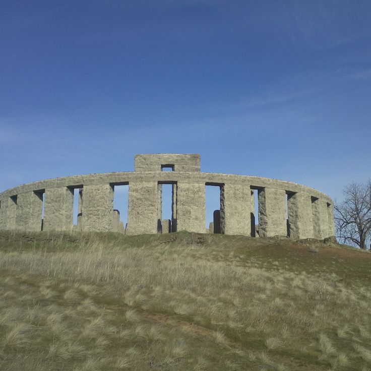
This concrete monument stands on a bluff above the Columbia River and was built by entrepreneur Samuel Hill as a memorial to Klickitat County soldiers who died in World War I. The structure replicates the dimensions of the English original and serves as an antiwar statement. The monument sits on the grounds of the Maryhill Museum of Art and provides views across the Columbia River Gorge. Visitors can explore the stone circle formation and tour the adjacent museum collections, which include works by Rodin and objects belonging to Queen Marie of Romania.
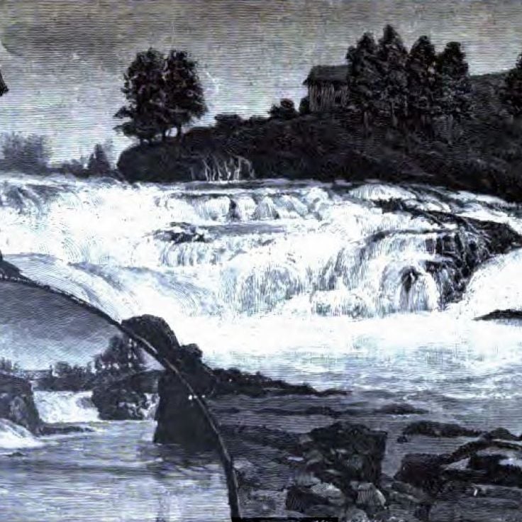
Spokane Falls drops 18 meters (60 feet) and powers a municipal hydroelectric facility generating 15 megawatts of energy. The falls have provided electricity to the city for over a century, channeling water from the Spokane River through turbines integrated into the urban landscape. Riverfront Park surrounds the falls, where visitors can observe the interaction between natural water flow and industrial infrastructure. Walking paths along the river provide access to viewing points above and beside the cascading water.
This 65-foot (20-meter) lighthouse from 1898 stands on a cliff and projects its light 17 miles (27 kilometers) across the Pacific Ocean. The station marks the entrance to the Columbia River and complements the Cape Disappointment Light to the south. The tower houses a first-order Fresnel lens that originally warned vessels of the hazardous waters at the river mouth. Visitors can tour the tower and associated buildings, which are part of Cape Disappointment State Park. The grounds provide hiking trails along the cliffs with views of the coastline and river.
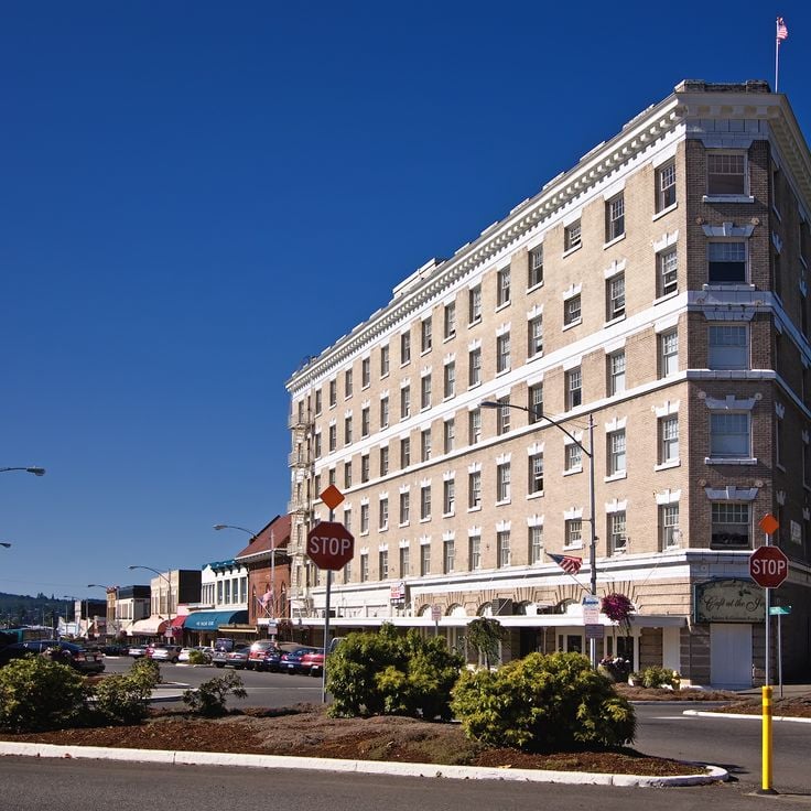
This 1930s building displays original Art Deco elements in its interior decoration, lobby and guest rooms. The architecture combines regional construction methods from the period with design features from the interwar years. The property preserves original materials and details from its construction era while continuing to operate as lodging. This historic site documents architectural development in Washington State during the Depression era and provides insight into Pacific coastal building traditions.
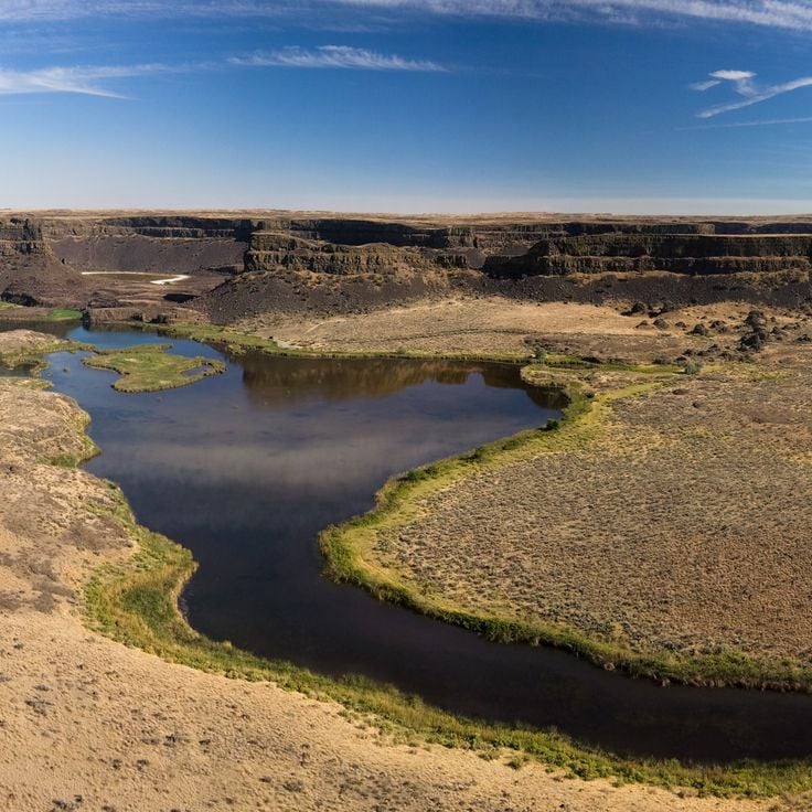
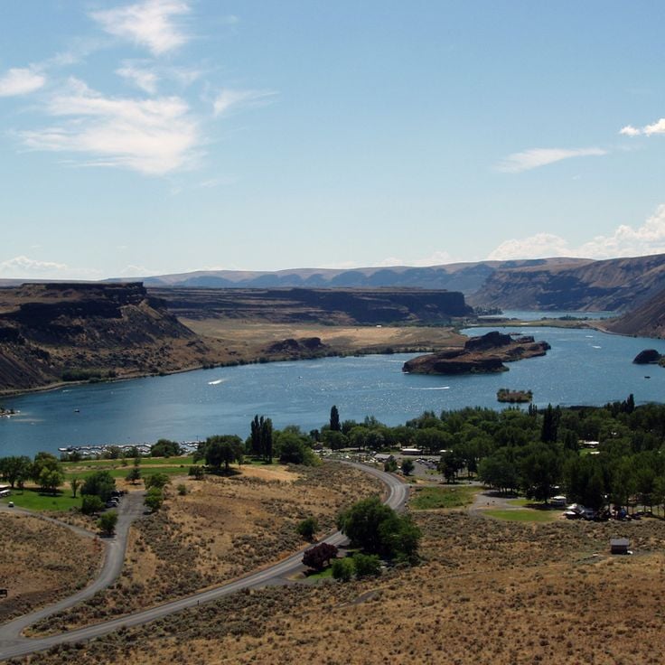
This geological formation was once a waterfall that spanned 3.5 miles (5.5 kilometers) in width and 400 feet (120 meters) in height. During the last ice age, approximately 13,000 years ago, a series of catastrophic glacial floods created the structure when Glacial Lake Missoula suddenly drained after ice dams broke. The water carved through basalt rock, forming a cliff that now stands dry. Dry Falls sits within the Coulee Corridor, part of the larger scablands created by these prehistoric flood events. Visitors can view the scale of this formation from an overlook positioned above the cliff face.
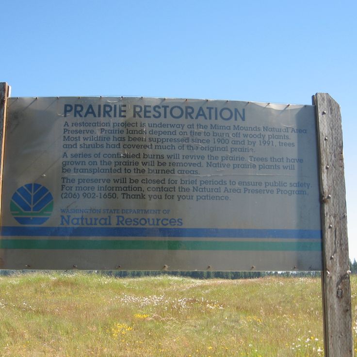
The Mima Mounds Natural Area Preserve protects several hundred mysterious earthen mounds that reach heights up to 6.5 feet (2 meters) and diameters of 33 feet (10 meters). These regularly spaced formations cover the prairie southwest of Olympia and have raised questions about their origin for decades. Geologists debate various theories, from glacial processes to rodent activity. The preserve offers trails through the mounded landscape and an observation deck for viewing the formations. Wildflowers bloom between the mounds in spring. An interpretive center explains the scientific investigations into this geological feature of Washington.
This coastal reserve covers 18,500 acres (7,500 hectares) along Puget Sound and protects farmland dating to the 1850s alongside buildings from the early settlement period. The site documents European colonization of the region through preserved farms, forests and historic structures. Visitors will find trails along the bluffs, beaches facing the Olympic Mountains and examples of 19th-century architecture.
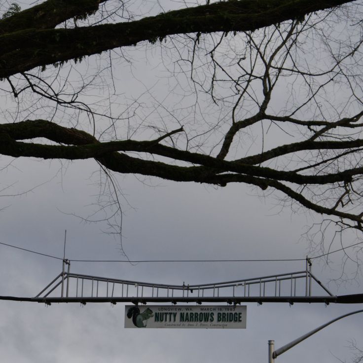
The Nutty Narrows Bridge is a 60-foot structure that provides squirrels with a protected crossing over a busy street between tree canopies. This 1960s initiative emerged after local residents observed increasing squirrel casualties from vehicle traffic. The bridge connects trees on opposite sides of a main thoroughfare and helps protect the local gray squirrel population. The project was later referenced as a model for similar wildlife crossing concepts in other communities.
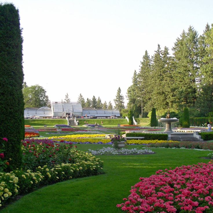
Manito Park covers 90 acres (36 hectares) in the heart of Spokane and combines designed garden areas with open green spaces. The grounds include a Japanese garden featuring traditional architectural elements, a conservatory housing tropical and subtropical plant collections, and several ponds and water features. Visitors also find a formal rose garden with hundreds of varieties, a lilac garden displaying over thirty species, and open lawn areas for recreation. The park was established in the early 20th century and showcases different horticultural styles. Multiple walking paths wind through the property, connecting the individual garden sections.
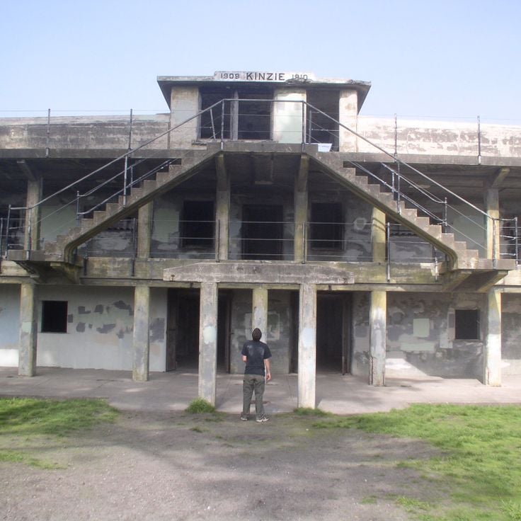
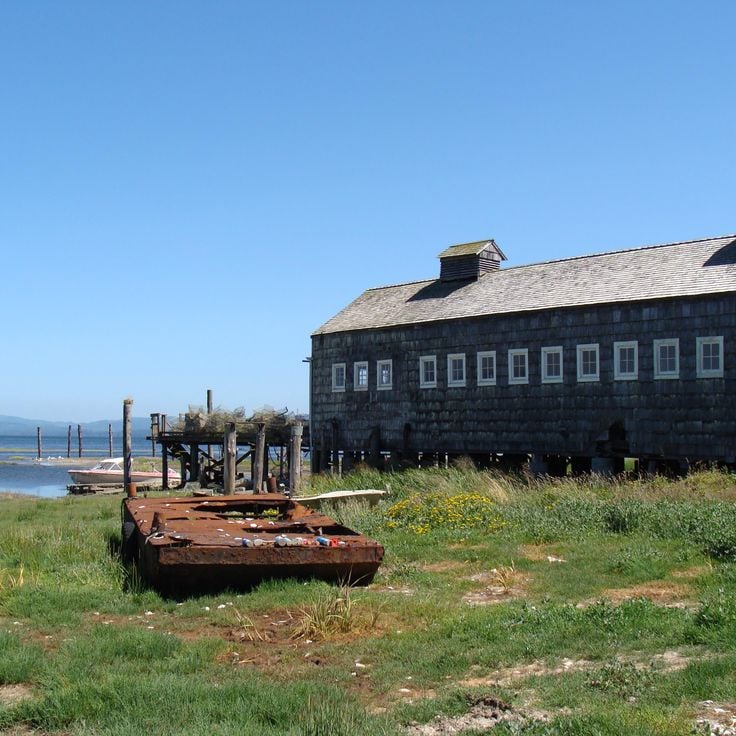
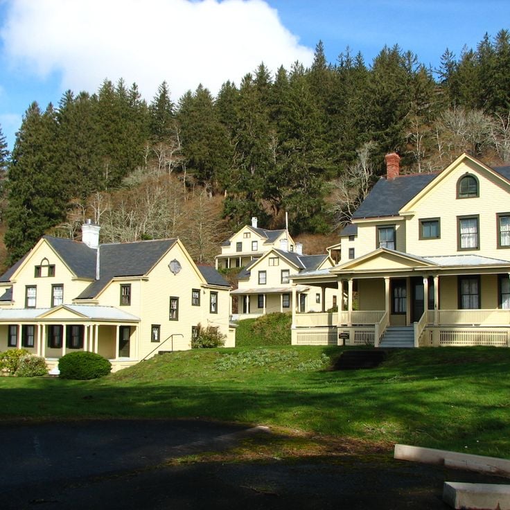
This former military installation from 1902 spans 180 acres (73 hectares) on the northern tip of the Olympic Peninsula and features artillery batteries, barracks buildings and a historic officers' row. Fort Worden served as a coastal defense post until 1953 and now provides access to beaches along Admiralty Inlet, trails through wooded areas and a working lighthouse dating to the late 1800s. The fort includes a marine science center and former military structures that serve as lodging and event spaces.
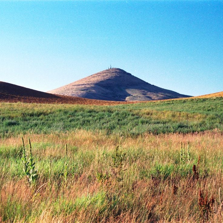
Steptoe Butte rises as an isolated quartzite cone to an elevation of 3,612 feet above the rolling wheat fields of the Palouse region. From the summit of this Precambrian geological remnant, a 360-degree view reveals an agricultural mosaic of golden grain fields stretching across gentle hills. A gravel road climbs to the top, where a small parking area and interpretive panels provide access. The formation stands among the few older rock outcrops that remained above the prehistoric flood waters during the Ice Age.
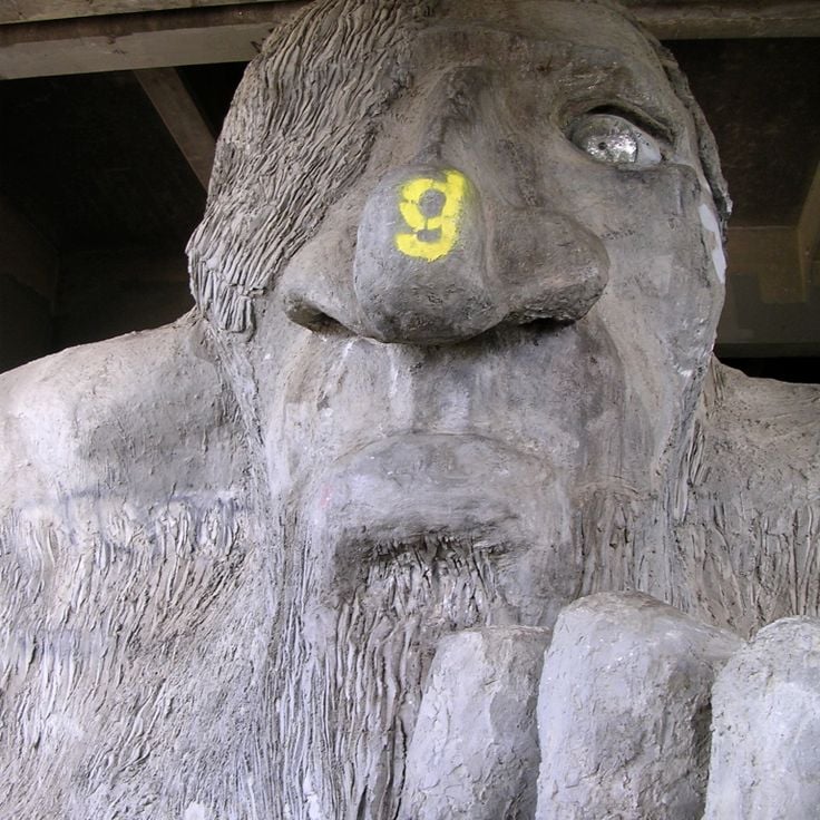
This 18-foot concrete sculpture beneath the Aurora Bridge depicts a troll clutching an actual Volkswagen Beetle. Four artists created the piece in 1990, and it has become a landmark of the Fremont neighborhood. The troll sits beneath the north end of the bridge at Troll Avenue N and remains accessible around the clock. Visitors can approach the sculpture for close viewing and photographs, with many noting the embedded details including a real hubcap serving as one eye.
This 60-acre wooded section preserves the history of Japanese immigrants who established a community here in the early 20th century. The trails wind through dense forest to the remains of logging camps and settlements, where foundations, tools and personal items document the daily work and life of these pioneers. The area served as an important site for timber industry and agricultural activity before residents were forcibly relocated during World War II. Interpretive signs along the paths explain the cultural practices, economic contributions and difficult history of this community in Washington.
This 8-mile (13-kilometer) sand spit extends into the Strait of Juan de Fuca, forming one of the longest natural sand spits in North America. Dungeness Spit contains an 1857 lighthouse that continues to serve as a navigational aid, along with part of Dungeness National Wildlife Refuge, where harbor seals, seabirds, and migratory waterfowl find shelter. The hike along the spit traverses driftwood and gravel beach to the lighthouse at the tip of the landform.
This 1854 village preserves wooden homes from the oyster harvesting boom in Shoalwater Bay. The Oysterville settlement features restored residential buildings, a church and a cemetery dating from the mid-1800s. The historic district documents the maritime economy that exported Pacific oysters to San Francisco between 1854 and the 1890s. Original structures line unpaved roads on the Long Beach Peninsula, representing one of the oldest continuously inhabited communities in Washington Territory.
The park encompasses several lakes formed by glacial floods in a system of gorges reaching 400 feet (120 meters) in depth. The water bodies lie in a dry region of the Columbia Plateau, where massive flows from glacial Lake Missoula carved the landscape approximately 13,000 years ago. The area displays steep basalt walls cut by repeated flooding events. The lakes provide access to geological formations created during the last ice age. This park documents the earth history of this Washington region.
The Turnbull refuge extends across 16,000 acres (6,500 hectares) of basalt formations, wetlands and ponds in Spokane County. The landscape was shaped by glacial erosion and provides habitat for over 200 bird species, including great egrets, Canada geese and various duck species. The terrain also supports white-tailed deer, elk and coyotes. Several trails wind through ponderosa pine forests and along water bodies that become particularly active during spring and fall migrations.
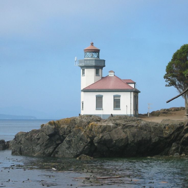
Lime Kiln Point Park contains a 1919 lighthouse and offshore waters where orcas swim regularly from May through September. The coastline provides viewing stations where visitors can watch migrating killer whales along with minke whales, sea lions and porpoises. The park covers roughly 15 acres (6 hectares) along the west shore of San Juan Island facing Haro Strait. Interpretive displays explain orca behavior and lighthouse history. Trails lead through coastal forests of Douglas fir and madrone to rocky shores where tides expose kelp and sea anemones.
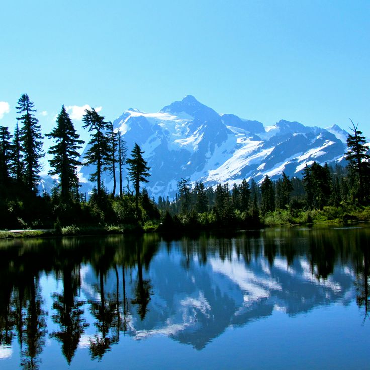
This viewpoint at 5200 feet (1585 meters) elevation provides unobstructed views of Mount Baker and Mount Shuksan in the North Cascades National Park area. The panoramic sights capture two glaciated volcanic peaks rising above surrounding valleys. The location marks the end of the Mount Baker Highway Scenic Byway and serves as a trailhead for several paths through subalpine meadows and volcanic terrain. The brief hiking season from July through September depends on snow conditions. Visitors find interpretive panels about the region's geological history and parking for approximately 30 vehicles.
Fort Columbia has guarded the mouth of the Columbia River since 1896, displaying coastal defense installations from the Spanish-American War era. The military post includes gun emplacements, a command post and barracks that remained operational until 1947. Visitors follow trails to observation points above the river and explore restored officers' quarters and administrative buildings. The interpretation center documents the region's military history and the post's role in Pacific coast defense.
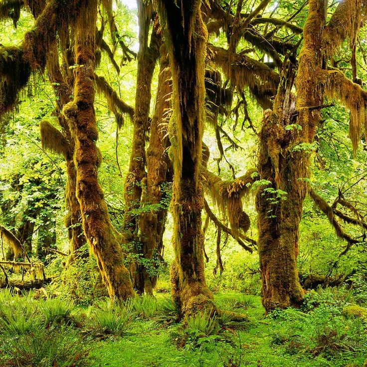
The visitor center sits within Olympic National Park and serves as a starting point for exploring the Hoh Rainforest. It presents exhibits on temperate rainforest ecosystems, native plant species and regional wildlife. Rangers provide information about trails through moss-covered forests of Sitka spruce and western hemlock. The center explains the annual rainfall of roughly 145 inches (370 centimeters) that shapes this environment and displays the ecological relationships between climate, vegetation and animal life. Visitors receive practical guidance on park routes and wildlife viewing opportunities.
The LeMay Automobile Museum displays over 350 vehicles spanning multiple decades of American automotive history. The collection includes models from the early days of motorization through to modern sports cars, documenting the technical and cultural evolution of the industry. Visitors can examine rare prototypes, race cars and everyday vehicles arranged in thematic sections throughout the facility.
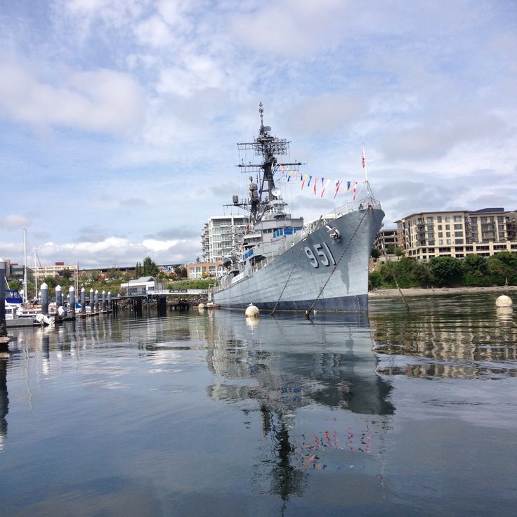
The USS Turner Joy is a restored naval destroyer that served during the Vietnam War and now operates as a museum. The ship preserves its original equipment, crew quarters, and command center. Visitors can navigate the narrow passageways, examine the gun turrets, and explore the operations rooms where tactical decisions were made during deployments. The ship participated in the 1964 Gulf of Tonkin incident that expanded American involvement in the Vietnam War. Exhibits detail the life of sailors aboard and explain the destroyer's role in naval operations.
The Goldendale Observatory State Park operates an astronomical center housing a 24-inch (61 cm) reflecting telescope. The facility conducts daytime solar observation sessions and guided nighttime stargazing programs. Located in southern Washington, the observatory provides access to some of the darkest skies in the region. Visitors can look through the main telescope and participate in educational programs about astronomy. The center opens year-round, with optimal viewing conditions during clear nights.
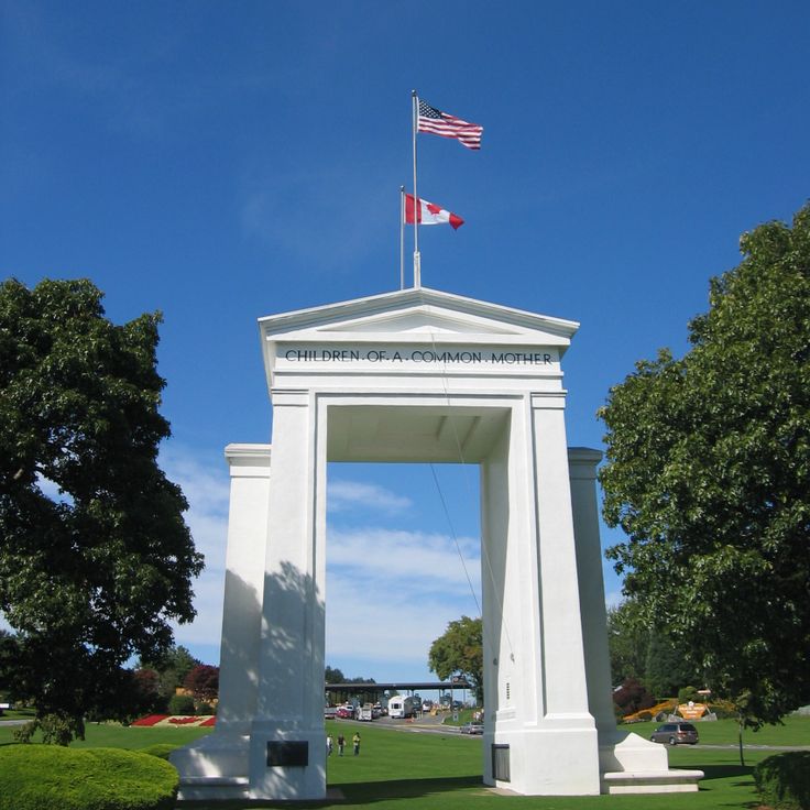
Peace Arch State Park sits on the international border between the United States and Canada in Blaine. The 67-foot (20-meter) arch was dedicated in 1921 and bears inscriptions honoring peaceful relations between the two nations. The park contains manicured lawns on both sides of the border, allowing visitors to move freely between countries during operating hours without passing through formal border controls. Many families use the grounds for picnics and gatherings with relatives from across the border. The arch itself stands on the boundary line, with its base half in Washington and half in British Columbia.
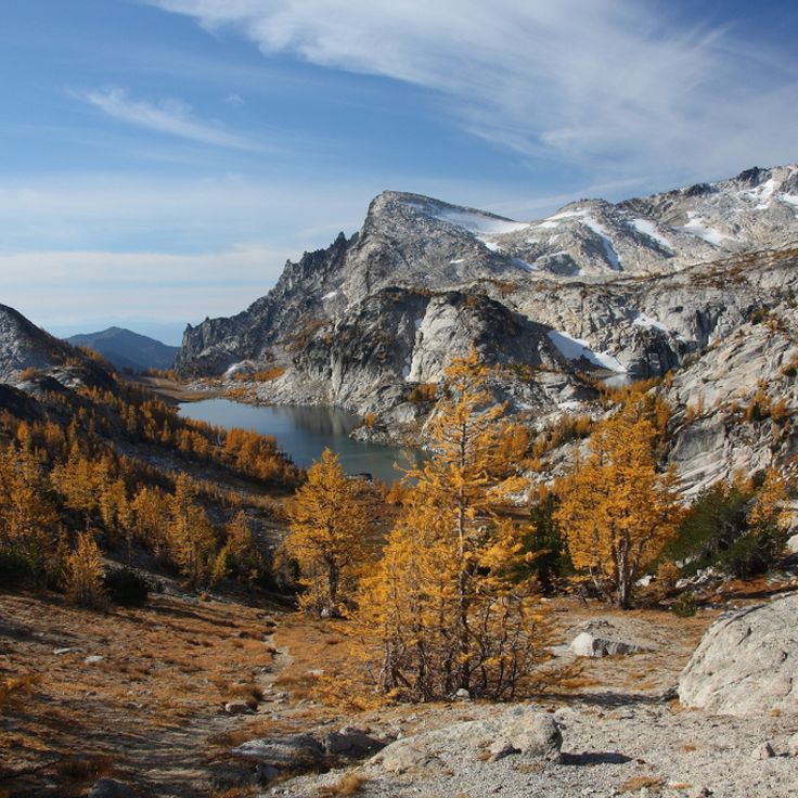
This mountain hiking area contains over 20 alpine lakes at elevations between 4,300 and 7,200 feet (1,300 and 2,200 meters) in the Cascade Range. The region sits within Wenatchee National Forest and draws hikers for multi-day treks through alpine terrain of granite peaks and coniferous forests. Access requires several trailheads, with a permit system limiting daily visitor numbers during summer months. Routes traverse steep terrain with elevation gains of roughly 3,000 feet (900 meters).
This 60-acre garden on Bainbridge Island contains formal landscapes, water gardens and forested areas with native plants from the Pacific Northwest. The Bloedel Reserve began in the 1950s as the private garden of the Bloedel family and later opened to the public. Visitors find tiered ponds, a Japanese-inspired garden and trails through old Douglas firs and Western Red Cedars. The reserve sits about 35 minutes from Seattle by ferry and requires advance reservations.
The Nordic Heritage Museum in Ballard documents the history of Scandinavian immigrants in the Pacific Northwest. The collection includes historical objects, photographs and personal documents that trace the experiences of Norwegian, Swedish, Danish, Finnish and Icelandic settlers from the 19th century onward. The museum presents rotating exhibitions on Nordic traditions, crafts and the contributions of Scandinavian communities to regional development. Cultural programs and educational events complement the permanent collections.
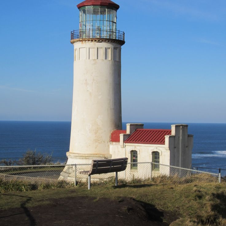
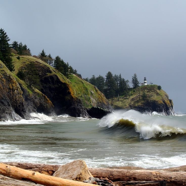
This state park preserves two historic lighthouses at the mouth of the Columbia River, where Lewis and Clark concluded their overland expedition in 1805. The interpretive center documents the Corps of Discovery's journey through exhibits and multimedia presentations. Hiking trails wind through coastal forest to overlooks above the Pacific, while camping areas provide access to several miles of beach. The North Head and Cape Disappointment lighthouses date from the late 1800s and helped navigate one of the most dangerous river bars on the West Coast.
The Wing Luke Museum documents the history of Asian immigrants in the Pacific Northwest region of the United States. Located in Seattle's International District, the museum presents exhibits on Chinese, Japanese, Filipino and Southeast Asian communities that have settled in the region since the 1880s. The collection includes personal belongings, photographs and oral histories from immigrant families. Guided tours of the historic neighborhood show preserved buildings and businesses operated by early Asian communities. The museum is named after Wing Luke, one of the first Asian Americans elected to public office in Washington.
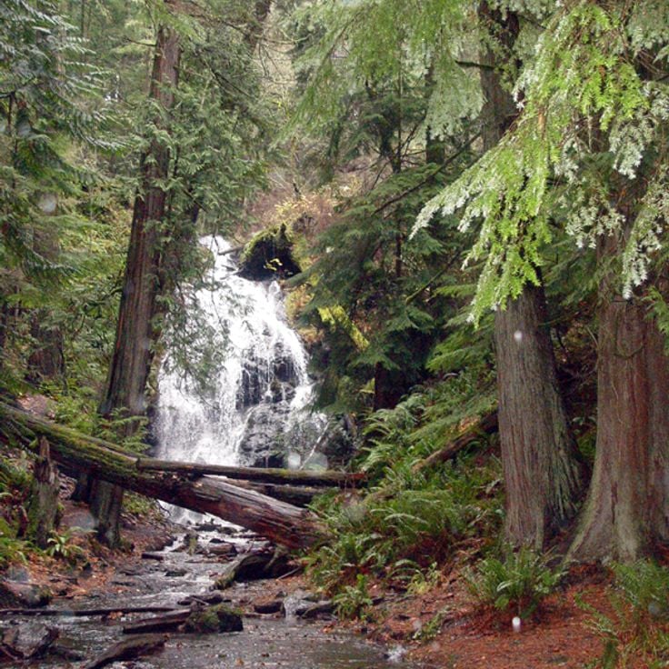
The park covers 1,100 acres (1.7 square miles) on the southwestern edge of the Cascade Range and provides access to nine separate waterfalls along the Wallace River. The trail system includes 7 miles of hiking routes through forests of Douglas fir and western hemlock that lead to the main cascade, which drops in three tiers to a total height of 260 feet. Higher elevation routes reach Jay Lake, Shaw Lake and Wallace Lake at 1,200 feet, offering views across the upper Skykomish River valley. Facilities include a year-round visitor center, several picnic areas and a designated backcountry camp near the upper falls.
Palouse Falls drops 198 feet (60 meters) into a basalt canyon in eastern Washington. The waterfall on the Palouse River sits approximately 4 miles (6 kilometers) upstream from where the river meets the Snake River. Water flows over a volcanic rock wall exposed during Ice Age floods at the end of the last glacial period. A park area with viewpoints provides access to the canyon, where trails lead to various positions along the cliffs. The falls carry the most water during spring snowmelt, when the river reaches its maximum volume.
This cape marks the northwesternmost point of the contiguous United States on the Olympic Peninsula. The half-mile trail through temperate rainforest leads to viewing platforms perched above cliffs overlooking the Pacific Ocean and the Strait of Juan de Fuca. Seabirds nest on offshore rock formations while gray whales pass during spring and fall migrations. The area sits on Makah tribal land and requires a tribal access permit.
The Ape Caves formed 2,000 years ago from a Mount St. Helens lava flow and extend through two miles of underground passages. These lava tubes offer visitors the chance to walk through volcanic formations created as the molten rock cooled and drained. The cave system lies in southwestern Washington and requires flashlights and sturdy footwear, as no lighting is installed. Access points along the trail lead into different sections, with some areas featuring low ceilings and uneven floors.
Beacon Rock rises 848 feet above the Columbia River as a prominent volcanic monolith within the Columbia River Gorge. This basalt formation emerged approximately 57,000 years ago as the core of a volcano whose outer layers eroded during the Missoula Floods. A trail with 52 switchbacks ascends to the summit through wooden walkways and rock-cut passages, offering views across the river and surrounding valleys. The path was constructed between 1915 and 1918 by Henry Biddle as part of his effort to preserve the rock from quarrying proposals.
The trail passes through a forest of Douglas firs and western red cedars exceeding 1,000 years in age, among the oldest trees in Mount Rainier National Park. The Patriarch Grove Trail extends roughly half a mile (0.8 kilometers) through the Ohanapecosh area, showcasing specimens with trunk diameters reaching 25 feet (7.6 meters). This forest provides insight into conifer growth under optimal conditions in the temperate rainforest environment of the Cascade Range. The path crosses a suspension bridge over the Ohanapecosh River and winds through one of the last intact old growth stands remaining in Washington State.
This steel arch bridge completed in 1935 spans a 180-foot (55-meter) channel with strong tidal currents between Whidbey Island and Fidalgo Island in northern Puget Sound. The bridge carries State Route 20 about 180 feet (55 meters) above the water and ranks among the most photographed bridges in the Pacific Northwest. Two parallel steel arches support the roadway, while pedestrian walkways on either side provide access to viewpoints over the water and forested islands. Trails beneath the bridge lead to small beaches where visitors can view the structure from below.
The Iron Goat Trail follows 6.2 miles (10 kilometers) of an abandoned railroad grade dating from 1893 through the Cascade Mountains. The route passes through several tunnels and snowshed galleries originally built to protect trains from avalanches. Interpretive signs document the history of the Great Northern Railway and the engineering challenges of mountain railroading. The mostly level path provides access to remnants of early Washington transportation infrastructure.
This coastal section sits along the Olympic Peninsula and shows several offshore rock formations that create tide pools with sea stars, anemones and small crabs during low tide. Ruby Beach extends roughly one mile and collects substantial amounts of driftwood washed ashore during winter storms. The Abbey Island rocks and other smaller formations rise about 100 feet (30 m) from the water and provide nesting sites for seabirds. The beach sits within the Olympic Coast and requires approximately a 2-mile (3-km) walk through coastal forest to reach.
This 5,700 acre (2,300 hectare) park on Orcas Island contains five lakes, 2,400 foot (730 meter) Mount Constitution, and 30 miles (50 kilometers) of trails through forests and along coastline. The park preserves old growth Douglas fir and western red cedar, some over 400 years old. From the stone observation tower at the summit, views extend across the San Juan Islands, the Cascade Range, and Vancouver Island. The park's waters attract bald eagles, ospreys, and various waterfowl. Visitors can swim, kayak, and fish at the lakes or explore historic 1930s buildings constructed by the Civilian Conservation Corps.
This concrete monument stands on a bluff above the Columbia River and was built by entrepreneur Samuel Hill as a memorial to Klickitat County soldiers who died in World War I. The structure replicates the dimensions of the English original and serves as an antiwar statement. The monument sits on the grounds of the Maryhill Museum of Art and provides views across the Columbia River Gorge. Visitors can explore the stone circle formation and tour the adjacent museum collections, which include works by Rodin and objects belonging to Queen Marie of Romania.
Spokane Falls drops 18 meters (60 feet) and powers a municipal hydroelectric facility generating 15 megawatts of energy. The falls have provided electricity to the city for over a century, channeling water from the Spokane River through turbines integrated into the urban landscape. Riverfront Park surrounds the falls, where visitors can observe the interaction between natural water flow and industrial infrastructure. Walking paths along the river provide access to viewing points above and beside the cascading water.
This 65-foot (20-meter) lighthouse from 1898 stands on a cliff and projects its light 17 miles (27 kilometers) across the Pacific Ocean. The station marks the entrance to the Columbia River and complements the Cape Disappointment Light to the south. The tower houses a first-order Fresnel lens that originally warned vessels of the hazardous waters at the river mouth. Visitors can tour the tower and associated buildings, which are part of Cape Disappointment State Park. The grounds provide hiking trails along the cliffs with views of the coastline and river.
This 1930s building displays original Art Deco elements in its interior decoration, lobby and guest rooms. The architecture combines regional construction methods from the period with design features from the interwar years. The property preserves original materials and details from its construction era while continuing to operate as lodging. This historic site documents architectural development in Washington State during the Depression era and provides insight into Pacific coastal building traditions.
This geological formation was once a waterfall that spanned 3.5 miles (5.5 kilometers) in width and 400 feet (120 meters) in height. During the last ice age, approximately 13,000 years ago, a series of catastrophic glacial floods created the structure when Glacial Lake Missoula suddenly drained after ice dams broke. The water carved through basalt rock, forming a cliff that now stands dry. Dry Falls sits within the Coulee Corridor, part of the larger scablands created by these prehistoric flood events. Visitors can view the scale of this formation from an overlook positioned above the cliff face.
The Mima Mounds Natural Area Preserve protects several hundred mysterious earthen mounds that reach heights up to 6.5 feet (2 meters) and diameters of 33 feet (10 meters). These regularly spaced formations cover the prairie southwest of Olympia and have raised questions about their origin for decades. Geologists debate various theories, from glacial processes to rodent activity. The preserve offers trails through the mounded landscape and an observation deck for viewing the formations. Wildflowers bloom between the mounds in spring. An interpretive center explains the scientific investigations into this geological feature of Washington.
This coastal reserve covers 18,500 acres (7,500 hectares) along Puget Sound and protects farmland dating to the 1850s alongside buildings from the early settlement period. The site documents European colonization of the region through preserved farms, forests and historic structures. Visitors will find trails along the bluffs, beaches facing the Olympic Mountains and examples of 19th-century architecture.
The Nutty Narrows Bridge is a 60-foot structure that provides squirrels with a protected crossing over a busy street between tree canopies. This 1960s initiative emerged after local residents observed increasing squirrel casualties from vehicle traffic. The bridge connects trees on opposite sides of a main thoroughfare and helps protect the local gray squirrel population. The project was later referenced as a model for similar wildlife crossing concepts in other communities.
Manito Park covers 90 acres (36 hectares) in the heart of Spokane and combines designed garden areas with open green spaces. The grounds include a Japanese garden featuring traditional architectural elements, a conservatory housing tropical and subtropical plant collections, and several ponds and water features. Visitors also find a formal rose garden with hundreds of varieties, a lilac garden displaying over thirty species, and open lawn areas for recreation. The park was established in the early 20th century and showcases different horticultural styles. Multiple walking paths wind through the property, connecting the individual garden sections.
This former military installation from 1902 spans 180 acres (73 hectares) on the northern tip of the Olympic Peninsula and features artillery batteries, barracks buildings and a historic officers' row. Fort Worden served as a coastal defense post until 1953 and now provides access to beaches along Admiralty Inlet, trails through wooded areas and a working lighthouse dating to the late 1800s. The fort includes a marine science center and former military structures that serve as lodging and event spaces.
Steptoe Butte rises as an isolated quartzite cone to an elevation of 3,612 feet above the rolling wheat fields of the Palouse region. From the summit of this Precambrian geological remnant, a 360-degree view reveals an agricultural mosaic of golden grain fields stretching across gentle hills. A gravel road climbs to the top, where a small parking area and interpretive panels provide access. The formation stands among the few older rock outcrops that remained above the prehistoric flood waters during the Ice Age.
This 18-foot concrete sculpture beneath the Aurora Bridge depicts a troll clutching an actual Volkswagen Beetle. Four artists created the piece in 1990, and it has become a landmark of the Fremont neighborhood. The troll sits beneath the north end of the bridge at Troll Avenue N and remains accessible around the clock. Visitors can approach the sculpture for close viewing and photographs, with many noting the embedded details including a real hubcap serving as one eye.
This 60-acre wooded section preserves the history of Japanese immigrants who established a community here in the early 20th century. The trails wind through dense forest to the remains of logging camps and settlements, where foundations, tools and personal items document the daily work and life of these pioneers. The area served as an important site for timber industry and agricultural activity before residents were forcibly relocated during World War II. Interpretive signs along the paths explain the cultural practices, economic contributions and difficult history of this community in Washington.
This 8-mile (13-kilometer) sand spit extends into the Strait of Juan de Fuca, forming one of the longest natural sand spits in North America. Dungeness Spit contains an 1857 lighthouse that continues to serve as a navigational aid, along with part of Dungeness National Wildlife Refuge, where harbor seals, seabirds, and migratory waterfowl find shelter. The hike along the spit traverses driftwood and gravel beach to the lighthouse at the tip of the landform.
This 1854 village preserves wooden homes from the oyster harvesting boom in Shoalwater Bay. The Oysterville settlement features restored residential buildings, a church and a cemetery dating from the mid-1800s. The historic district documents the maritime economy that exported Pacific oysters to San Francisco between 1854 and the 1890s. Original structures line unpaved roads on the Long Beach Peninsula, representing one of the oldest continuously inhabited communities in Washington Territory.
The park encompasses several lakes formed by glacial floods in a system of gorges reaching 400 feet (120 meters) in depth. The water bodies lie in a dry region of the Columbia Plateau, where massive flows from glacial Lake Missoula carved the landscape approximately 13,000 years ago. The area displays steep basalt walls cut by repeated flooding events. The lakes provide access to geological formations created during the last ice age. This park documents the earth history of this Washington region.
The Turnbull refuge extends across 16,000 acres (6,500 hectares) of basalt formations, wetlands and ponds in Spokane County. The landscape was shaped by glacial erosion and provides habitat for over 200 bird species, including great egrets, Canada geese and various duck species. The terrain also supports white-tailed deer, elk and coyotes. Several trails wind through ponderosa pine forests and along water bodies that become particularly active during spring and fall migrations.
Lime Kiln Point Park contains a 1919 lighthouse and offshore waters where orcas swim regularly from May through September. The coastline provides viewing stations where visitors can watch migrating killer whales along with minke whales, sea lions and porpoises. The park covers roughly 15 acres (6 hectares) along the west shore of San Juan Island facing Haro Strait. Interpretive displays explain orca behavior and lighthouse history. Trails lead through coastal forests of Douglas fir and madrone to rocky shores where tides expose kelp and sea anemones.
This viewpoint at 5200 feet (1585 meters) elevation provides unobstructed views of Mount Baker and Mount Shuksan in the North Cascades National Park area. The panoramic sights capture two glaciated volcanic peaks rising above surrounding valleys. The location marks the end of the Mount Baker Highway Scenic Byway and serves as a trailhead for several paths through subalpine meadows and volcanic terrain. The brief hiking season from July through September depends on snow conditions. Visitors find interpretive panels about the region's geological history and parking for approximately 30 vehicles.
Fort Columbia has guarded the mouth of the Columbia River since 1896, displaying coastal defense installations from the Spanish-American War era. The military post includes gun emplacements, a command post and barracks that remained operational until 1947. Visitors follow trails to observation points above the river and explore restored officers' quarters and administrative buildings. The interpretation center documents the region's military history and the post's role in Pacific coast defense.
The visitor center sits within Olympic National Park and serves as a starting point for exploring the Hoh Rainforest. It presents exhibits on temperate rainforest ecosystems, native plant species and regional wildlife. Rangers provide information about trails through moss-covered forests of Sitka spruce and western hemlock. The center explains the annual rainfall of roughly 145 inches (370 centimeters) that shapes this environment and displays the ecological relationships between climate, vegetation and animal life. Visitors receive practical guidance on park routes and wildlife viewing opportunities.
The LeMay Automobile Museum displays over 350 vehicles spanning multiple decades of American automotive history. The collection includes models from the early days of motorization through to modern sports cars, documenting the technical and cultural evolution of the industry. Visitors can examine rare prototypes, race cars and everyday vehicles arranged in thematic sections throughout the facility.
The USS Turner Joy is a restored naval destroyer that served during the Vietnam War and now operates as a museum. The ship preserves its original equipment, crew quarters, and command center. Visitors can navigate the narrow passageways, examine the gun turrets, and explore the operations rooms where tactical decisions were made during deployments. The ship participated in the 1964 Gulf of Tonkin incident that expanded American involvement in the Vietnam War. Exhibits detail the life of sailors aboard and explain the destroyer's role in naval operations.
The Goldendale Observatory State Park operates an astronomical center housing a 24-inch (61 cm) reflecting telescope. The facility conducts daytime solar observation sessions and guided nighttime stargazing programs. Located in southern Washington, the observatory provides access to some of the darkest skies in the region. Visitors can look through the main telescope and participate in educational programs about astronomy. The center opens year-round, with optimal viewing conditions during clear nights.
Peace Arch State Park sits on the international border between the United States and Canada in Blaine. The 67-foot (20-meter) arch was dedicated in 1921 and bears inscriptions honoring peaceful relations between the two nations. The park contains manicured lawns on both sides of the border, allowing visitors to move freely between countries during operating hours without passing through formal border controls. Many families use the grounds for picnics and gatherings with relatives from across the border. The arch itself stands on the boundary line, with its base half in Washington and half in British Columbia.
This mountain hiking area contains over 20 alpine lakes at elevations between 4,300 and 7,200 feet (1,300 and 2,200 meters) in the Cascade Range. The region sits within Wenatchee National Forest and draws hikers for multi-day treks through alpine terrain of granite peaks and coniferous forests. Access requires several trailheads, with a permit system limiting daily visitor numbers during summer months. Routes traverse steep terrain with elevation gains of roughly 3,000 feet (900 meters).
This 60-acre garden on Bainbridge Island contains formal landscapes, water gardens and forested areas with native plants from the Pacific Northwest. The Bloedel Reserve began in the 1950s as the private garden of the Bloedel family and later opened to the public. Visitors find tiered ponds, a Japanese-inspired garden and trails through old Douglas firs and Western Red Cedars. The reserve sits about 35 minutes from Seattle by ferry and requires advance reservations.
The Nordic Heritage Museum in Ballard documents the history of Scandinavian immigrants in the Pacific Northwest. The collection includes historical objects, photographs and personal documents that trace the experiences of Norwegian, Swedish, Danish, Finnish and Icelandic settlers from the 19th century onward. The museum presents rotating exhibitions on Nordic traditions, crafts and the contributions of Scandinavian communities to regional development. Cultural programs and educational events complement the permanent collections.
This state park preserves two historic lighthouses at the mouth of the Columbia River, where Lewis and Clark concluded their overland expedition in 1805. The interpretive center documents the Corps of Discovery's journey through exhibits and multimedia presentations. Hiking trails wind through coastal forest to overlooks above the Pacific, while camping areas provide access to several miles of beach. The North Head and Cape Disappointment lighthouses date from the late 1800s and helped navigate one of the most dangerous river bars on the West Coast.
The Wing Luke Museum documents the history of Asian immigrants in the Pacific Northwest region of the United States. Located in Seattle's International District, the museum presents exhibits on Chinese, Japanese, Filipino and Southeast Asian communities that have settled in the region since the 1880s. The collection includes personal belongings, photographs and oral histories from immigrant families. Guided tours of the historic neighborhood show preserved buildings and businesses operated by early Asian communities. The museum is named after Wing Luke, one of the first Asian Americans elected to public office in Washington.
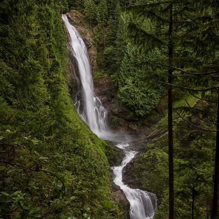
The park covers 1,100 acres (1.7 square miles) on the southwestern edge of the Cascade Range and provides access to nine separate waterfalls along the Wallace River. The trail system includes 7 miles of hiking routes through forests of Douglas fir and western hemlock that lead to the main cascade, which drops in three tiers to a total height of 260 feet. Higher elevation routes reach Jay Lake, Shaw Lake and Wallace Lake at 1,200 feet, offering views across the upper Skykomish River valley. Facilities include a year-round visitor center, several picnic areas and a designated backcountry camp near the upper falls.
Palouse Falls drops 198 feet (60 meters) into a basalt canyon in eastern Washington. The waterfall on the Palouse River sits approximately 4 miles (6 kilometers) upstream from where the river meets the Snake River. Water flows over a volcanic rock wall exposed during Ice Age floods at the end of the last glacial period. A park area with viewpoints provides access to the canyon, where trails lead to various positions along the cliffs. The falls carry the most water during spring snowmelt, when the river reaches its maximum volume.
This cape marks the northwesternmost point of the contiguous United States on the Olympic Peninsula. The half-mile trail through temperate rainforest leads to viewing platforms perched above cliffs overlooking the Pacific Ocean and the Strait of Juan de Fuca. Seabirds nest on offshore rock formations while gray whales pass during spring and fall migrations. The area sits on Makah tribal land and requires a tribal access permit.
The Ape Caves formed 2,000 years ago from a Mount St. Helens lava flow and extend through two miles of underground passages. These lava tubes offer visitors the chance to walk through volcanic formations created as the molten rock cooled and drained. The cave system lies in southwestern Washington and requires flashlights and sturdy footwear, as no lighting is installed. Access points along the trail lead into different sections, with some areas featuring low ceilings and uneven floors.
Beacon Rock rises 848 feet above the Columbia River as a prominent volcanic monolith within the Columbia River Gorge. This basalt formation emerged approximately 57,000 years ago as the core of a volcano whose outer layers eroded during the Missoula Floods. A trail with 52 switchbacks ascends to the summit through wooden walkways and rock-cut passages, offering views across the river and surrounding valleys. The path was constructed between 1915 and 1918 by Henry Biddle as part of his effort to preserve the rock from quarrying proposals.
The trail passes through a forest of Douglas firs and western red cedars exceeding 1,000 years in age, among the oldest trees in Mount Rainier National Park. The Patriarch Grove Trail extends roughly half a mile (0.8 kilometers) through the Ohanapecosh area, showcasing specimens with trunk diameters reaching 25 feet (7.6 meters). This forest provides insight into conifer growth under optimal conditions in the temperate rainforest environment of the Cascade Range. The path crosses a suspension bridge over the Ohanapecosh River and winds through one of the last intact old growth stands remaining in Washington State.
This steel arch bridge completed in 1935 spans a 180-foot (55-meter) channel with strong tidal currents between Whidbey Island and Fidalgo Island in northern Puget Sound. The bridge carries State Route 20 about 180 feet (55 meters) above the water and ranks among the most photographed bridges in the Pacific Northwest. Two parallel steel arches support the roadway, while pedestrian walkways on either side provide access to viewpoints over the water and forested islands. Trails beneath the bridge lead to small beaches where visitors can view the structure from below.
The Iron Goat Trail follows 6.2 miles (10 kilometers) of an abandoned railroad grade dating from 1893 through the Cascade Mountains. The route passes through several tunnels and snowshed galleries originally built to protect trains from avalanches. Interpretive signs document the history of the Great Northern Railway and the engineering challenges of mountain railroading. The mostly level path provides access to remnants of early Washington transportation infrastructure.
This coastal section sits along the Olympic Peninsula and shows several offshore rock formations that create tide pools with sea stars, anemones and small crabs during low tide. Ruby Beach extends roughly one mile and collects substantial amounts of driftwood washed ashore during winter storms. The Abbey Island rocks and other smaller formations rise about 100 feet (30 m) from the water and provide nesting sites for seabirds. The beach sits within the Olympic Coast and requires approximately a 2-mile (3-km) walk through coastal forest to reach.
This 5,700 acre (2,300 hectare) park on Orcas Island contains five lakes, 2,400 foot (730 meter) Mount Constitution, and 30 miles (50 kilometers) of trails through forests and along coastline. The park preserves old growth Douglas fir and western red cedar, some over 400 years old. From the stone observation tower at the summit, views extend across the San Juan Islands, the Cascade Range, and Vancouver Island. The park's waters attract bald eagles, ospreys, and various waterfowl. Visitors can swim, kayak, and fish at the lakes or explore historic 1930s buildings constructed by the Civilian Conservation Corps.
This concrete monument stands on a bluff above the Columbia River and was built by entrepreneur Samuel Hill as a memorial to Klickitat County soldiers who died in World War I. The structure replicates the dimensions of the English original and serves as an antiwar statement. The monument sits on the grounds of the Maryhill Museum of Art and provides views across the Columbia River Gorge. Visitors can explore the stone circle formation and tour the adjacent museum collections, which include works by Rodin and objects belonging to Queen Marie of Romania.
Spokane Falls drops 18 meters (60 feet) and powers a municipal hydroelectric facility generating 15 megawatts of energy. The falls have provided electricity to the city for over a century, channeling water from the Spokane River through turbines integrated into the urban landscape. Riverfront Park surrounds the falls, where visitors can observe the interaction between natural water flow and industrial infrastructure. Walking paths along the river provide access to viewing points above and beside the cascading water.
This 65-foot (20-meter) lighthouse from 1898 stands on a cliff and projects its light 17 miles (27 kilometers) across the Pacific Ocean. The station marks the entrance to the Columbia River and complements the Cape Disappointment Light to the south. The tower houses a first-order Fresnel lens that originally warned vessels of the hazardous waters at the river mouth. Visitors can tour the tower and associated buildings, which are part of Cape Disappointment State Park. The grounds provide hiking trails along the cliffs with views of the coastline and river.
This 1930s building displays original Art Deco elements in its interior decoration, lobby and guest rooms. The architecture combines regional construction methods from the period with design features from the interwar years. The property preserves original materials and details from its construction era while continuing to operate as lodging. This historic site documents architectural development in Washington State during the Depression era and provides insight into Pacific coastal building traditions.
This geological formation was once a waterfall that spanned 3.5 miles (5.5 kilometers) in width and 400 feet (120 meters) in height. During the last ice age, approximately 13,000 years ago, a series of catastrophic glacial floods created the structure when Glacial Lake Missoula suddenly drained after ice dams broke. The water carved through basalt rock, forming a cliff that now stands dry. Dry Falls sits within the Coulee Corridor, part of the larger scablands created by these prehistoric flood events. Visitors can view the scale of this formation from an overlook positioned above the cliff face.
The Mima Mounds Natural Area Preserve protects several hundred mysterious earthen mounds that reach heights up to 6.5 feet (2 meters) and diameters of 33 feet (10 meters). These regularly spaced formations cover the prairie southwest of Olympia and have raised questions about their origin for decades. Geologists debate various theories, from glacial processes to rodent activity. The preserve offers trails through the mounded landscape and an observation deck for viewing the formations. Wildflowers bloom between the mounds in spring. An interpretive center explains the scientific investigations into this geological feature of Washington.
This coastal reserve covers 18,500 acres (7,500 hectares) along Puget Sound and protects farmland dating to the 1850s alongside buildings from the early settlement period. The site documents European colonization of the region through preserved farms, forests and historic structures. Visitors will find trails along the bluffs, beaches facing the Olympic Mountains and examples of 19th-century architecture.
The Nutty Narrows Bridge is a 60-foot structure that provides squirrels with a protected crossing over a busy street between tree canopies. This 1960s initiative emerged after local residents observed increasing squirrel casualties from vehicle traffic. The bridge connects trees on opposite sides of a main thoroughfare and helps protect the local gray squirrel population. The project was later referenced as a model for similar wildlife crossing concepts in other communities.
Manito Park covers 90 acres (36 hectares) in the heart of Spokane and combines designed garden areas with open green spaces. The grounds include a Japanese garden featuring traditional architectural elements, a conservatory housing tropical and subtropical plant collections, and several ponds and water features. Visitors also find a formal rose garden with hundreds of varieties, a lilac garden displaying over thirty species, and open lawn areas for recreation. The park was established in the early 20th century and showcases different horticultural styles. Multiple walking paths wind through the property, connecting the individual garden sections.
This former military installation from 1902 spans 180 acres (73 hectares) on the northern tip of the Olympic Peninsula and features artillery batteries, barracks buildings and a historic officers' row. Fort Worden served as a coastal defense post until 1953 and now provides access to beaches along Admiralty Inlet, trails through wooded areas and a working lighthouse dating to the late 1800s. The fort includes a marine science center and former military structures that serve as lodging and event spaces.
Steptoe Butte rises as an isolated quartzite cone to an elevation of 3,612 feet above the rolling wheat fields of the Palouse region. From the summit of this Precambrian geological remnant, a 360-degree view reveals an agricultural mosaic of golden grain fields stretching across gentle hills. A gravel road climbs to the top, where a small parking area and interpretive panels provide access. The formation stands among the few older rock outcrops that remained above the prehistoric flood waters during the Ice Age.
This 18-foot concrete sculpture beneath the Aurora Bridge depicts a troll clutching an actual Volkswagen Beetle. Four artists created the piece in 1990, and it has become a landmark of the Fremont neighborhood. The troll sits beneath the north end of the bridge at Troll Avenue N and remains accessible around the clock. Visitors can approach the sculpture for close viewing and photographs, with many noting the embedded details including a real hubcap serving as one eye.
This 60-acre wooded section preserves the history of Japanese immigrants who established a community here in the early 20th century. The trails wind through dense forest to the remains of logging camps and settlements, where foundations, tools and personal items document the daily work and life of these pioneers. The area served as an important site for timber industry and agricultural activity before residents were forcibly relocated during World War II. Interpretive signs along the paths explain the cultural practices, economic contributions and difficult history of this community in Washington.
This 8-mile (13-kilometer) sand spit extends into the Strait of Juan de Fuca, forming one of the longest natural sand spits in North America. Dungeness Spit contains an 1857 lighthouse that continues to serve as a navigational aid, along with part of Dungeness National Wildlife Refuge, where harbor seals, seabirds, and migratory waterfowl find shelter. The hike along the spit traverses driftwood and gravel beach to the lighthouse at the tip of the landform.
This 1854 village preserves wooden homes from the oyster harvesting boom in Shoalwater Bay. The Oysterville settlement features restored residential buildings, a church and a cemetery dating from the mid-1800s. The historic district documents the maritime economy that exported Pacific oysters to San Francisco between 1854 and the 1890s. Original structures line unpaved roads on the Long Beach Peninsula, representing one of the oldest continuously inhabited communities in Washington Territory.
The park encompasses several lakes formed by glacial floods in a system of gorges reaching 400 feet (120 meters) in depth. The water bodies lie in a dry region of the Columbia Plateau, where massive flows from glacial Lake Missoula carved the landscape approximately 13,000 years ago. The area displays steep basalt walls cut by repeated flooding events. The lakes provide access to geological formations created during the last ice age. This park documents the earth history of this Washington region.
The Turnbull refuge extends across 16,000 acres (6,500 hectares) of basalt formations, wetlands and ponds in Spokane County. The landscape was shaped by glacial erosion and provides habitat for over 200 bird species, including great egrets, Canada geese and various duck species. The terrain also supports white-tailed deer, elk and coyotes. Several trails wind through ponderosa pine forests and along water bodies that become particularly active during spring and fall migrations.
Lime Kiln Point Park contains a 1919 lighthouse and offshore waters where orcas swim regularly from May through September. The coastline provides viewing stations where visitors can watch migrating killer whales along with minke whales, sea lions and porpoises. The park covers roughly 15 acres (6 hectares) along the west shore of San Juan Island facing Haro Strait. Interpretive displays explain orca behavior and lighthouse history. Trails lead through coastal forests of Douglas fir and madrone to rocky shores where tides expose kelp and sea anemones.
This viewpoint at 5200 feet (1585 meters) elevation provides unobstructed views of Mount Baker and Mount Shuksan in the North Cascades National Park area. The panoramic sights capture two glaciated volcanic peaks rising above surrounding valleys. The location marks the end of the Mount Baker Highway Scenic Byway and serves as a trailhead for several paths through subalpine meadows and volcanic terrain. The brief hiking season from July through September depends on snow conditions. Visitors find interpretive panels about the region's geological history and parking for approximately 30 vehicles.
Fort Columbia has guarded the mouth of the Columbia River since 1896, displaying coastal defense installations from the Spanish-American War era. The military post includes gun emplacements, a command post and barracks that remained operational until 1947. Visitors follow trails to observation points above the river and explore restored officers' quarters and administrative buildings. The interpretation center documents the region's military history and the post's role in Pacific coast defense.
The visitor center sits within Olympic National Park and serves as a starting point for exploring the Hoh Rainforest. It presents exhibits on temperate rainforest ecosystems, native plant species and regional wildlife. Rangers provide information about trails through moss-covered forests of Sitka spruce and western hemlock. The center explains the annual rainfall of roughly 145 inches (370 centimeters) that shapes this environment and displays the ecological relationships between climate, vegetation and animal life. Visitors receive practical guidance on park routes and wildlife viewing opportunities.
The LeMay Automobile Museum displays over 350 vehicles spanning multiple decades of American automotive history. The collection includes models from the early days of motorization through to modern sports cars, documenting the technical and cultural evolution of the industry. Visitors can examine rare prototypes, race cars and everyday vehicles arranged in thematic sections throughout the facility.
The USS Turner Joy is a restored naval destroyer that served during the Vietnam War and now operates as a museum. The ship preserves its original equipment, crew quarters, and command center. Visitors can navigate the narrow passageways, examine the gun turrets, and explore the operations rooms where tactical decisions were made during deployments. The ship participated in the 1964 Gulf of Tonkin incident that expanded American involvement in the Vietnam War. Exhibits detail the life of sailors aboard and explain the destroyer's role in naval operations.
The Goldendale Observatory State Park operates an astronomical center housing a 24-inch (61 cm) reflecting telescope. The facility conducts daytime solar observation sessions and guided nighttime stargazing programs. Located in southern Washington, the observatory provides access to some of the darkest skies in the region. Visitors can look through the main telescope and participate in educational programs about astronomy. The center opens year-round, with optimal viewing conditions during clear nights.
Peace Arch State Park sits on the international border between the United States and Canada in Blaine. The 67-foot (20-meter) arch was dedicated in 1921 and bears inscriptions honoring peaceful relations between the two nations. The park contains manicured lawns on both sides of the border, allowing visitors to move freely between countries during operating hours without passing through formal border controls. Many families use the grounds for picnics and gatherings with relatives from across the border. The arch itself stands on the boundary line, with its base half in Washington and half in British Columbia.
This mountain hiking area contains over 20 alpine lakes at elevations between 4,300 and 7,200 feet (1,300 and 2,200 meters) in the Cascade Range. The region sits within Wenatchee National Forest and draws hikers for multi-day treks through alpine terrain of granite peaks and coniferous forests. Access requires several trailheads, with a permit system limiting daily visitor numbers during summer months. Routes traverse steep terrain with elevation gains of roughly 3,000 feet (900 meters).
This 60-acre garden on Bainbridge Island contains formal landscapes, water gardens and forested areas with native plants from the Pacific Northwest. The Bloedel Reserve began in the 1950s as the private garden of the Bloedel family and later opened to the public. Visitors find tiered ponds, a Japanese-inspired garden and trails through old Douglas firs and Western Red Cedars. The reserve sits about 35 minutes from Seattle by ferry and requires advance reservations.
The Nordic Heritage Museum in Ballard documents the history of Scandinavian immigrants in the Pacific Northwest. The collection includes historical objects, photographs and personal documents that trace the experiences of Norwegian, Swedish, Danish, Finnish and Icelandic settlers from the 19th century onward. The museum presents rotating exhibitions on Nordic traditions, crafts and the contributions of Scandinavian communities to regional development. Cultural programs and educational events complement the permanent collections.
This state park preserves two historic lighthouses at the mouth of the Columbia River, where Lewis and Clark concluded their overland expedition in 1805. The interpretive center documents the Corps of Discovery's journey through exhibits and multimedia presentations. Hiking trails wind through coastal forest to overlooks above the Pacific, while camping areas provide access to several miles of beach. The North Head and Cape Disappointment lighthouses date from the late 1800s and helped navigate one of the most dangerous river bars on the West Coast.
The Wing Luke Museum documents the history of Asian immigrants in the Pacific Northwest region of the United States. Located in Seattle's International District, the museum presents exhibits on Chinese, Japanese, Filipino and Southeast Asian communities that have settled in the region since the 1880s. The collection includes personal belongings, photographs and oral histories from immigrant families. Guided tours of the historic neighborhood show preserved buildings and businesses operated by early Asian communities. The museum is named after Wing Luke, one of the first Asian Americans elected to public office in Washington.
The park covers 1,100 acres (1.7 square miles) on the southwestern edge of the Cascade Range and provides access to nine separate waterfalls along the Wallace River. The trail system includes 7 miles of hiking routes through forests of Douglas fir and western hemlock that lead to the main cascade, which drops in three tiers to a total height of 260 feet. Higher elevation routes reach Jay Lake, Shaw Lake and Wallace Lake at 1,200 feet, offering views across the upper Skykomish River valley. Facilities include a year-round visitor center, several picnic areas and a designated backcountry camp near the upper falls.