Enable Location

We need your location to show you interesting places around you

Discover nearby places

Find interesting locations and hidden gems around you

Precise directions

Get accurate directions and distances to places

Your location is never shared with other users. It's only used when you tap the location button.

Interstate 78

Log in to your account

Start exploring — it's free

Trusted by 63,121 travelers worldwide

Continue with Google
Continue with Apple
or

We will send you a code to connect

By continuing, you accept our Terms and Conditions and our Privacy Policy

Check your inbox

We've sent a pincode in your inbox. Please enter the code below.

Interstate 78
Discussion Reviews 1 Photos
32.6k Popularity

Interstate 78, Interstate highway in New Jersey, United States

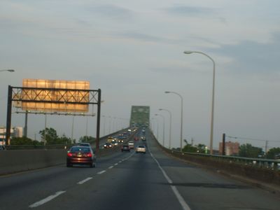
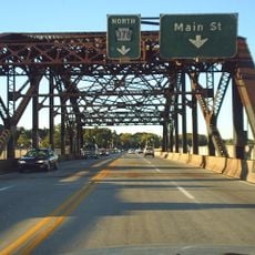
Interstate 78 is a federal highway that spans roughly 68 miles (109 kilometers) across northern New Jersey. It runs from the Delaware River at Phillipsburg to the Holland Tunnel in Jersey City, providing access to multiple airports and the New Jersey Turnpike.

Construction began in 1957 as part of the Eisenhower program to expand the American highway system. A section was later named after the Lightning Division, an Army unit with historical significance to the region.

The highway passes through regions with different characters, from rural areas in the west to densely built urban zones near Newark. It connects various local communities and enables daily commute flows between residential areas and employment centers.

The road has separate express and local lanes in some areas and several rest stops distributed along the route. Plan for extra time if you are traveling during peak hours or are unfamiliar with the route.

The road is a critical hub for cargo transport and connects three major airports in the New York metropolitan area. This traffic flow makes it one of the most vital transportation routes on the East Coast.

The community of curious travelers

AroundUs brings together thousands of curated places, local tips, and hidden gems, enriched daily by 60,000 contributors worldwide.

Start exploring
Location
Inception
1957
GPS coordinates
40.58000,-75.38770
Latest update
December 20, 2025 00:21
Around this place
Martin Tower
United States of America

Martin Tower

5.8 km
Goodman Stadium
United States of America

Goodman Stadium

2.9 km
Stabler Arena
United States of America

Stabler Arena

2.7 km
Lost River Caverns
United States of America

Lost River Caverns

4.8 km
Lehigh Valley Silk Mills
United States of America

Lehigh Valley Silk Mills

2.8 km
Hill to Hill Bridge
United States of America

Hill to Hill Bridge

4 km
Central Park
United States of America

Central Park

5.5 km
Bethlehem Waterworks
United States of America

Bethlehem Waterworks

4.4 km
Historic Moravian Bethlehem Historic District
United States of America

Historic Moravian Bethlehem Historic District

4.4 km
Burnside Plantation
United States of America

Burnside Plantation

5.7 km
Cathedral Church of the Nativity
United States of America

Cathedral Church of the Nativity

3.5 km
Philip J. Fahy Memorial Bridge
United States of America

Philip J. Fahy Memorial Bridge

4 km
Gemeinhaus-Lewis David de Schweinitz Residence
United States of America

Gemeinhaus-Lewis David de Schweinitz Residence

4.3 km
Central Bethlehem Historic District
United States of America

Central Bethlehem Historic District

4.3 km
Bethlehem Steel Lehigh Plant Mill No. 2 Annex
United States of America

Bethlehem Steel Lehigh Plant Mill No. 2 Annex

4 km
The Tannery
United States of America

The Tannery

4.4 km
South Bethlehem Downtown Historic District
United States of America

South Bethlehem Downtown Historic District

3.8 km
Fountain Hill Historic District
United States of America

Fountain Hill Historic District

3.5 km
Centennial Bridge
United States of America

Centennial Bridge

5.7 km
Bethlehem Silk Mill
United States of America

Bethlehem Silk Mill

5.2 km
Elmwood Park Historic District
United States of America

Elmwood Park Historic District

5.3 km
Michael and Margaret Heller House
United States of America

Michael and Margaret Heller House

3.4 km
Gristmiller's House
United States of America

Gristmiller's House

4.6 km
Ehrhart's Mill Historic District
United States of America

Ehrhart's Mill Historic District

3.8 km
National Museum of Industrial History
United States of America

National Museum of Industrial History

3.9 km
Minsi Trail Bridge
United States of America

Minsi Trail Bridge

4.8 km
Movies
United States of America

Movies

4 km
Astor Theatre
United States of America

Astor Theatre

5.7 km
Show the full map
Reviews
Share your experience

No review yet

Discussions
Start a discussion...

No discussion yet

« Interstate 78 - Interstate highway in New Jersey, United States » is provided by Around Us (aroundus.com). Images and texts are derived from Wikimedia project under a Creative Commons license. You are allowed to copy, distribute, and modify copies of this page, under the conditions set by the license, as long as this note is clearly visible.

Discover hidden gems everywhere you go!

From secret cafés to breathtaking viewpoints, skip the crowded tourist spots and find places that match your style. Our app makes it easy with voice search, smart filtering, route optimization, and insider tips from travelers worldwide. Download now for the complete mobile experience.

Around Us App Screenshot

A unique approach to discovering new places

Le Figaro

All the places worth exploring

France Info

A tailor-made excursion in just a few clicks

20 Minutes

Around Us
Travel Guide & Maps
Download

Send to your phone

QR Code
1

Open the camera app on your mobile.

2

Point at the QR code with your camera. A notification will appear.

3

Tap the notification to open the link.