Chest opened
+${chestReward.xp} XP
Explorer
NOUVEAU ×${chestReward.collectible.quantity}
tapez pour fermer
Chest locked

Open chests in the app

Around Us is built for your phone — chests unlock when you walk, explore and capture nearby places.

Enable Location

We need your location to show you interesting places around you

Discover nearby places

Find interesting locations and hidden gems around you

Precise directions

Get accurate directions and distances to places

Your location is never shared with other users. It's only used when you tap the location button.

Log in to your account

Start exploring — it's free

Trusted by 72,887 travelers worldwide

Continue with Google
Continue with Apple
or

We will send you a code to connect

By continuing, you accept our Terms and Conditions and our Privacy Policy

Check your inbox

We've sent a pincode in your inbox. Please enter the code below.

Discussion Reviews Photo
34.4k Popularity

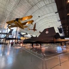
Dulles, Unincorporated community in Loudoun County, United States

Dulles is an unincorporated community in Loudoun County, Virginia, encompassing residential neighborhoods, commercial centers, and technology business facilities. The area spreads across the southwestern portion of Sterling and serves as a hub for commerce and innovation in Northern Virginia.

The area was named after John Foster Dulles, who served as Secretary of State under President Dwight D. Eisenhower in the 1950s. This naming honors his role in American diplomacy during the Cold War era.

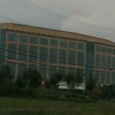
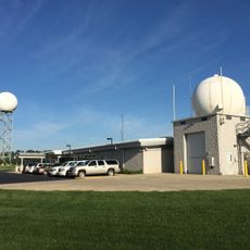
The National Weather Service maintains both a forecast office and a field support center in Dulles, contributing to national meteorological research.

Visitors should know that addresses in this area officially use Sterling as the city name for postal purposes, even though the place is known as Dulles. The ZIP code 20166 is standard for mailings to this region.

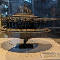
Major technology companies like Northrop Grumman Innovation Systems and ODIN Technologies have established significant operations here, making it an important center for aerospace and defense work. The presence of the National Weather Service forecast office adds another layer of federal activity to the community.

The community of curious travelers

AroundUs brings together thousands of curated places, local tips, and hidden gems, enriched daily by 60,000 contributors worldwide.

Start exploring
Location
GPS coordinates
38.95170,-77.44810
Latest update
December 19, 2025 22:49
Around this place
Steven F. Udvar-Hazy Center
United States of America

Steven F. Udvar-Hazy Center

4.5 km
CIA University
United States of America

CIA University

4.2 km
Sully Historic Site
United States of America

Sully Historic Site

6.7 km
A. Smith Bowman Distillery
United States of America

A. Smith Bowman Distillery

8.4 km
Ox Hill Battlefield Park
United States of America

Ox Hill Battlefield Park

11.9 km
Lake Fairfax Park
United States of America

Lake Fairfax Park

11.3 km
Ellanor C. Lawrence Park
United States of America

Ellanor C. Lawrence Park

10.6 km
National Weather Service Baltimore/Washington
United States of America

National Weather Service Baltimore/Washington

4.3 km
Arcola Elementary School
United States of America

Arcola Elementary School

7.7 km
Dranesville Tavern
United States of America

Dranesville Tavern

9.8 km
Lake Anne Village Center Historic District
United States of America

Lake Anne Village Center Historic District

9.5 km
Broad Run Bridge and Tollhouse
United States of America

Broad Run Bridge and Tollhouse

10.7 km
Donald D. Engen Observation Tower
United States of America

Donald D. Engen Observation Tower

4.5 km
Arcola Slave Quarters
United States of America

Arcola Slave Quarters

6.9 km
Fleetwood Farm
United States of America

Fleetwood Farm

10.7 km
Merrybrook
United States of America

Merrybrook

3.4 km
Herndon Historic District
United States of America

Herndon Historic District

5.8 km
Ashburn Presbyterian Church
United States of America

Ashburn Presbyterian Church

10.2 km
Vestal's Gap Road and Lanesville Historic District
United States of America

Vestal's Gap Road and Lanesville Historic District

8.3 km
Frying Pan Meetinghouse
United States of America

Frying Pan Meetinghouse

3.3 km
Cox Farms
United States of America

Cox Farms

8.7 km
Bloomfield
United States of America

Bloomfield

10.1 km
Floris Historic District
United States of America

Floris Historic District

3.8 km
Vale School-Community House
United States of America

Vale School-Community House

10.9 km
Loudoun Heritage Farm Museum
United States of America

Loudoun Heritage Farm Museum

8.2 km
Amazing Farm Fun
United States of America

Amazing Farm Fun

10.1 km
Ray Muth Sr. Memorial Park
United States of America

Ray Muth Sr. Memorial Park

9.3 km
Cascades Library
United States of America

Cascades Library

10.3 km
Show the full map
Reviews
Share your experience

No review yet

Discussions
Start a discussion...

No discussion yet

« Dulles - Unincorporated community in Loudoun County, United States » is provided by Around Us (aroundus.com). Images and texts are derived from Wikimedia project under a Creative Commons license. You are allowed to copy, distribute, and modify copies of this page, under the conditions set by the license, as long as this note is clearly visible.

Discover hidden gems everywhere you go!

From secret cafés to breathtaking viewpoints, skip the crowded tourist spots and find places that match your style. Our app makes it easy with voice search, smart filtering, route optimization, and insider tips from travelers worldwide. Download now for the complete mobile experience.

Around Us App Screenshot

A unique approach to discovering new places

Le Figaro

All the places worth exploring

France Info

A tailor-made excursion in just a few clicks

20 Minutes

Around Us
Travel Guide & Maps
Download

Send to your phone

QR Code
1

Open the camera app on your mobile.

2

Point at the QR code with your camera. A notification will appear.

3

Tap the notification to open the link.