Enable Location

We need your location to show you interesting places around you

Discover nearby places

Find interesting locations and hidden gems around you

Precise directions

Get accurate directions and distances to places

Your location is never shared with other users. It's only used when you tap the location button.

Fort Frances – International Falls International Bridge

Log in to your account

Start exploring — it's free

Trusted by 62,370 travelers worldwide

Continue with Google
Continue with Apple
or

We will send you a code to connect

By continuing, you accept our Terms and Conditions and our Privacy Policy

Check your inbox

We've sent a pincode in your inbox. Please enter the code below.

Fort Frances – International Falls International Bridge

Fort Frances – International Falls International Bridge, International toll bridge between Fort Frances, Ontario and International Falls, Minnesota

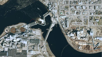
The Fort Frances-International Falls International Bridge is a combined road and rail crossing spanning 274 meters over the Rainy River. Vehicles and trains share the same level, with trucks and freight services using the central section alongside passenger traffic.

Built in 1912 by a paper company, the bridge has functioned as a vital gateway between Canada and the United States for over a century. Its steel structure became a crucial crossing point for trade and travel between the two nations.

The bridge serves as a physical connection between two border communities, allowing daily interactions and the free flow of people between Ontario and Minnesota.

Be ready for delays when trains pass, as they take priority and temporarily close the crossing to vehicles. Pedestrians and vehicles heading south can cross without paying any toll.

What makes this crossing unusual is that trains and vehicles operate on the same level without separation, requiring careful coordination between different types of traffic. This shared approach is rare among border crossings where rail and road typically operate on different levels.

The community of curious travelers

AroundUs brings together thousands of curated places, local tips, and hidden gems, enriched daily by 60,000 contributors worldwide.

Start exploring
Location
Length
274 m
Part of
Canada–United States border
GPS coordinates
48.60722,-93.40194
Latest update
December 9, 2025 18:48
Around this place
Voyageurs National Park
United States of America

Voyageurs National Park

40 km
Big Bog State Recreation Area
United States of America

Big Bog State Recreation Area

94.1 km
Kettle Falls Hotel
United States of America

Kettle Falls Hotel

57.3 km
Grand Mound
United States of America

Grand Mound

24.7 km
Kay-Nah-Chi-Wah-Nung
Canada

Kay-Nah-Chi-Wah-Nung

49.7 km
Fort Saint Pierre
Canada

Fort Saint Pierre

3.3 km
Kabetogama State Forest
United States of America

Kabetogama State Forest

32.8 km
Franz Jevne State Park
United States of America

Franz Jevne State Park

49.9 km
Kettle Falls Historic District
United States of America

Kettle Falls Historic District

57.3 km
Jun Fujita Cabin
United States of America

Jun Fujita Cabin

39.6 km
Sts. Peter and Paul Russian Orthodox Church
United States of America

Sts. Peter and Paul Russian Orthodox Church

80.1 km
Finstad's Auto Marine Shop
United States of America

Finstad's Auto Marine Shop

4.1 km
William Ingersoll Estate
United States of America

William Ingersoll Estate

74.1 km
Kabetogama Ranger Station District
United States of America

Kabetogama Ranger Station District

32.9 km
Koochiching County Courthouse
United States of America

Koochiching County Courthouse

922 m
Orr Roadside Parking Area
United States of America

Orr Roadside Parking Area

74.2 km
Civilian Conservation Corps Camp S-52
United States of America

Civilian Conservation Corps Camp S-52

69.8 km
Gold Mine Sites
United States of America

Gold Mine Sites

17.2 km
Sturgeon River State Forest
United States of America

Sturgeon River State Forest

96 km
Ash River Lookout Tower
United States of America

Ash River Lookout Tower

50.5 km
Kabetogama Lookout Tower
United States of America

Kabetogama Lookout Tower

40.3 km
Ash River Visitor Center
United States of America

Ash River Visitor Center

44.9 km
Kabetogama Lake Visitor Center
United States of America

Kabetogama Lake Visitor Center

32.8 km
Rainy Lake Visitor Center
United States of America

Rainy Lake Visitor Center

17.9 km
Elephant Lake Lookout Tower
United States of America

Elephant Lake Lookout Tower

67.7 km
Rapid River Fire Tower
United States of America

Rapid River Fire Tower

83.3 km
Black Bay Lookout Tower
United States of America

Black Bay Lookout Tower

16.8 km
Gheen Hill Lookout Tower
United States of America

Gheen Hill Lookout Tower

81.8 km
Show the full map
« Fort Frances – International Falls International Bridge - International toll bridge between Fort Frances, Ontario and International Falls, Minnesota » is provided by Around Us (aroundus.com). Images and texts are derived from Wikimedia project under a Creative Commons license. You are allowed to copy, distribute, and modify copies of this page, under the conditions set by the license, as long as this note is clearly visible.

Discover hidden gems everywhere you go!

From secret cafés to breathtaking viewpoints, skip the crowded tourist spots and find places that match your style. Our app makes it easy with voice search, smart filtering, route optimization, and insider tips from travelers worldwide. Download now for the complete mobile experience.

Around Us App Screenshot

A unique approach to discovering new places

Le Figaro

All the places worth exploring

France Info

A tailor-made excursion in just a few clicks

20 Minutes

Around Us
Travel Guide & Maps
Download

Send to your phone

QR Code
1

Open the camera app on your mobile.

2

Point at the QR code with your camera. A notification will appear.

3

Tap the notification to open the link.