Enable Location

We need your location to show you interesting places around you

Discover nearby places

Find interesting locations and hidden gems around you

Precise directions

Get accurate directions and distances to places

Your location is never shared with other users. It's only used when you tap the location button.

Nanase Dam

Log in to your account

Start exploring — it's free

Trusted by 65,407 travelers worldwide

Continue with Google
Continue with Apple
or

We will send you a code to connect

By continuing, you accept our Terms and Conditions and our Privacy Policy

Check your inbox

We've sent a pincode in your inbox. Please enter the code below.

Nanase Dam
Discussion Reviews 1 Photos
4k Popularity

Nanase Dam, Embankment dam in Oita Prefecture, Japan

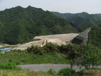
Nanase Dam is an embankment dam on the Oita River in eastern Kyushu, standing about 85.5 meters above the riverbed. It is built from compacted earth and rock fill, a construction method that gives it a broad, sloping profile rather than a vertical concrete face.

Work on the dam began in the 1970s as part of a wider effort to address water shortages and flood risk in Oita Prefecture. It was completed in 1978 and has been supplying water to the region for household and agricultural use ever since.

From the viewing area, visitors can see how the reservoir stretches back into the forested hills, forming a long narrow lake that follows the natural shape of the valley. The surrounding landscape is largely untouched, and the site draws visitors who come to walk along the water's edge.

The site is located in a mountainous area where public transport is limited, so arriving by car is the most practical option. A parking area and a viewing point near the dam face make it easy to get a clear look without needing to walk far.

Although the dam is primarily a water supply structure, it also plays a key role in managing the heavy seasonal rainfall that hits this part of Kyushu every summer. The Oita River catchment receives some of the highest rainfall totals on the island, which shaped the design of the dam's spillway systems.

The community of curious travelers

AroundUs brings together thousands of curated places, local tips, and hidden gems, enriched daily by 60,000 contributors worldwide.

Start exploring
Location
Inception
1978
Height
85.5 m
GPS coordinates
33.79056,131.60778
Latest update
March 3, 2026 10:05
Reviews
Share your experience

No review yet

Discussions
Start a discussion...

No discussion yet

« Nanase Dam - Embankment dam in Oita Prefecture, Japan » is provided by Around Us (aroundus.com). Images and texts are derived from Wikimedia project under a Creative Commons license. You are allowed to copy, distribute, and modify copies of this page, under the conditions set by the license, as long as this note is clearly visible.

Discover hidden gems everywhere you go!

From secret cafés to breathtaking viewpoints, skip the crowded tourist spots and find places that match your style. Our app makes it easy with voice search, smart filtering, route optimization, and insider tips from travelers worldwide. Download now for the complete mobile experience.

Around Us App Screenshot

A unique approach to discovering new places

Le Figaro

All the places worth exploring

France Info

A tailor-made excursion in just a few clicks

20 Minutes

Around Us
Travel Guide & Maps
Download

Send to your phone

QR Code
1

Open the camera app on your mobile.

2

Point at the QR code with your camera. A notification will appear.

3

Tap the notification to open the link.