Enable Location

We need your location to show you interesting places around you

Discover nearby places

Find interesting locations and hidden gems around you

Precise directions

Get accurate directions and distances to places

Your location is never shared with other users. It's only used when you tap the location button.

Chōrōga-dake

Log in to your account

Start exploring — it's free

Trusted by 61,922 travelers worldwide

Continue with Google
Continue with Apple
or

We will send you a code to connect

By continuing, you accept our Terms and Conditions and our Privacy Policy

Check your inbox

We've sent a pincode in your inbox. Please enter the code below.

Chōrōga-dake

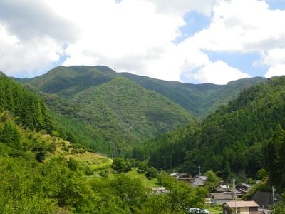
Chōrōga-dake, Mountain summit in Nantan and Kyotamba, Japan

Chōrōga-dake is a 917 meter peak sitting on the border between Nantan and Kyotamba with several hiking trails through thick forests. The slopes feature natural rock outcrops and vegetation that changes with elevation.

The mountain was recognized as part of the 100 Famous Kansai Mountains, a list honoring the geological character of the region. This designation reflects its natural features and place in the local landscape.

The mountain draws visitors seeking connection with the natural landscape that has shaped the region. Walking its trails shows how people relate to this place as part of their surroundings.

Hikers can reach the trails from multiple entry points around Nantan and Kyotamba, with clear markings to guide the way. The best season for walking is when weather is mild and trails are dry.

The mountain is home to a special tree formation called Nanairo no Ki, where multiple tree species grow closely together in one spot. This natural occurrence is uncommon and draws the attention of nature observers.

The community of curious travelers

AroundUs brings together thousands of curated places, local tips, and hidden gems, enriched daily by 60,000 contributors worldwide.

Start exploring
Location
Location
Elevation above the sea
916.9 m
Part of
100 Famous Kansai Mountains
GPS coordinates
35.30322,135.47388
Latest update
December 14, 2025 09:45
« Chōrōga-dake - Mountain summit in Nantan and Kyotamba, Japan » is provided by Around Us (aroundus.com). Images and texts are derived from Wikimedia project under a Creative Commons license. You are allowed to copy, distribute, and modify copies of this page, under the conditions set by the license, as long as this note is clearly visible.

Discover hidden gems everywhere you go!

From secret cafés to breathtaking viewpoints, skip the crowded tourist spots and find places that match your style. Our app makes it easy with voice search, smart filtering, route optimization, and insider tips from travelers worldwide. Download now for the complete mobile experience.

Around Us App Screenshot

A unique approach to discovering new places

Le Figaro

All the places worth exploring

France Info

A tailor-made excursion in just a few clicks

20 Minutes

Around Us
Travel Guide & Maps
Download

Send to your phone

QR Code
1

Open the camera app on your mobile.

2

Point at the QR code with your camera. A notification will appear.

3

Tap the notification to open the link.