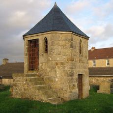
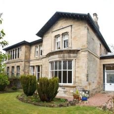
Glorat House, Category B listed mansion in East Dunbartonshire, Scotland.
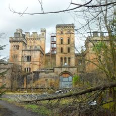
Glorat House is a large mansion in East Dunbartonshire that brings together architectural features from different building periods. The residence displays preserved stonework from the 17th century alongside a tower added in the 19th century, with both elements visible in its current structure.
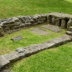
The original tower house built in 1510 was replaced during the 17th century, with a lintel dated 1625 bearing the initials MS for Mungo Stirling. Later in the 19th century, the house underwent significant reconstruction and received its distinctive Scots Baronial character.
The Stirling family of Glorat, who received their baronetcy in 1680, maintained this residence as their family seat through generations.
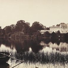
The mansion sits within gardens laid out during the first half of the 19th century, covering approximately 60 hectares. Visitors will find plenty of room to walk and explore the surrounding grounds at their own pace.
The 1869 reconstruction transformed the building into the Scots Baronial style while retaining elements from its earlier 17th-century structure.
Location: East Dunbartonshire
Location: Campsie
GPS coordinates: 55.97400,-4.17850
Latest update: December 13, 2025 17:10
Antonine Wall
7 km
Lennoxtown training centre
3.1 km
Bar Hill Roman fort
6.8 km
Lennox Castle
3.6 km
Bardowie Castle
7.5 km
Adamslie Park
4.1 km
Auchendavy Roman fort
4.6 km
Auld Aisle Cemetery, Kirkintilloch
5.3 km
Lenzie Moss
6 km
St Cyprian's Church, Lenzie
5.3 km
Kirkintilloch Town Hall
4 km
Forth And Clyde Canal, Luggie Water Aqueduct
4.2 km
Lenzie Old Parish Church
6 km
Campsie High Church
1.3 km
Old Parish Church of St. Mary
3.9 km
Peggie's Spout
5.6 km
Kilsyth, Howe Street, Burial-ground
7.5 km
Black Spout
4.5 km
Kilsyth Parish Church
7.4 km
Cawder House
6.2 km
Warwick Croft
6.4 km
Kirkintilloch, Cowgate, St Mary's Parish Church
4.1 km
Baldernock Parish Church
7 km
Kirkintilloch, Union Street, Holy Family And St Ninian's R.c. Church
4 km
Bar Hill, Roman temporary camp SW of
6.8 km
Baldernock Mill
7.2 km
Woodhead House
3.6 km
Antonine Wall, Bar Hill, rampart, ditch, fort and Military Way
6.9 kmVisited this place? Tap the stars to rate it and share your experience / photos with the community! Try now! You can cancel it anytime.
Discover hidden gems everywhere you go!
From secret cafés to breathtaking viewpoints, skip the crowded tourist spots and find places that match your style. Our app makes it easy with voice search, smart filtering, route optimization, and insider tips from travelers worldwide. Download now for the complete mobile experience.
A unique approach to discovering new places❞
— Le Figaro
All the places worth exploring❞
— France Info
A tailor-made excursion in just a few clicks❞
— 20 Minutes