Enable Location

We need your location to show you interesting places around you

Discover nearby places

Find interesting locations and hidden gems around you

Precise directions

Get accurate directions and distances to places

Your location is never shared with other users. It's only used when you tap the location button.

Posey County

Log in to your account

Start exploring — it's free

Trusted by 62,173 travelers worldwide

Continue with Google
Continue with Apple
or

We will send you a code to connect

By continuing, you accept our Terms and Conditions and our Privacy Policy

Check your inbox

We've sent a pincode in your inbox. Please enter the code below.

Posey County, County seat and administrative division in southwestern Indiana, US

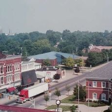
Posey County is an administrative division in southwestern Indiana with Mount Vernon serving as its county seat. The area sits along the Ohio River and contains several neighborhoods and downtown districts recognized for their historical architecture.

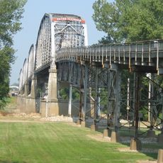
The settlement began in 1806 under the name McFaden's Bluff and was renamed Mount Vernon in 1816 to honor George Washington's estate. The county grew into a regional administrative center with deep ties to Ohio River commerce and river transportation.

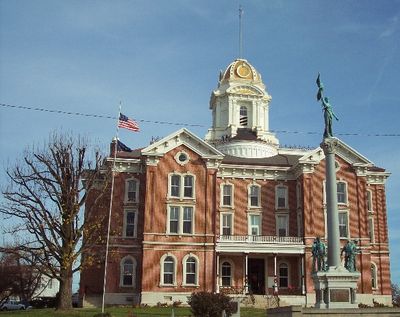
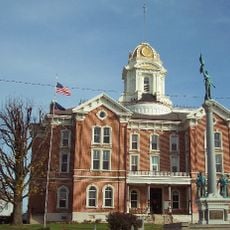
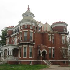
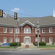
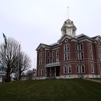
The Posey County Courthouse Square, Mount Vernon Downtown Historic District, and Welborn Historic District represent protected architectural heritage on the National Register.

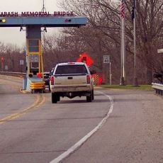
The county is accessible by local roads with Mount Vernon positioned directly on the riverfront. Historic districts in the area are walkable, and visitors can explore public buildings and local facilities easily.

The Ports of Indiana facility at Mount Vernon was established in 1976 and remains the state's largest public port. It handles significant river commerce and connects the region to broader shipping routes along the Ohio River.

The community of curious travelers

AroundUs brings together thousands of curated places, local tips, and hidden gems, enriched daily by 60,000 contributors worldwide.

Start exploring
Location
Inception
September 7, 1814
Capital city
Mount Vernon
Shares border with
Gibson County, Vanderburgh County, Henderson County, Union County, Gallatin County, White County
GPS coordinates
38.02000,-87.86000
Latest update
December 7, 2025 19:26
Around this place
New Harmony's Atheneum
United States of America

New Harmony's Atheneum

14.2 km
Roofless Church
United States of America

Roofless Church

14.1 km
John T. Myers Locks and Dam
United States of America

John T. Myers Locks and Dam

27.7 km
Mann Site
United States of America

Mann Site

12.1 km
Wabash Memorial Bridge
United States of America

Wabash Memorial Bridge

17.6 km
United States of America

Welborn Village Archeological Site

27.5 km
Hovey Lake Archaeological District
United States of America

Hovey Lake Archaeological District

21.8 km
Hubele Mounds and Village Site
United States of America

Hubele Mounds and Village Site

15.1 km
Ashworth Archaeological Site
United States of America

Ashworth Archaeological Site

20.1 km
Hovey Lake Fish and Wildlife Area
United States of America

Hovey Lake Fish and Wildlife Area

23.5 km
Wilson Mounds and Village Site
United States of America

Wilson Mounds and Village Site

15.3 km
Amon Clarence Thomas House
United States of America

Amon Clarence Thomas House

13.9 km
Posey County Courthouse Square
United States of America

Posey County Courthouse Square

10.2 km
Bieker-Wilson Village Site
United States of America

Bieker-Wilson Village Site

22.2 km
Mattias Scholle House
United States of America

Mattias Scholle House

13.7 km
James Robert Williams House
United States of America

James Robert Williams House

27.3 km
George Bentel House
United States of America

George Bentel House

13.8 km
Duffy Site
United States of America

Duffy Site

27.4 km
Ludwig Epple House
United States of America

Ludwig Epple House

13.9 km
I.O.O.F. and Barker Buildings
United States of America

I.O.O.F. and Barker Buildings

10.3 km
Mount Vernon Downtown Historic District
United States of America

Mount Vernon Downtown Historic District

10.4 km
Welborn Historic District
United States of America

Welborn Historic District

10 km
William Gonnerman House
United States of America

William Gonnerman House

10.7 km
Historic New Harmony Atheneum
United States of America

Historic New Harmony Atheneum

14.2 km
New Harmony Toll Bridge
United States of America

New Harmony Toll Bridge

14.3 km
New Harmony Historic District
United States of America

New Harmony Historic District

13.9 km
The Labyrinth State Memorial
United States of America

The Labyrinth State Memorial

13.2 km
James Elliott Farm
United States of America

James Elliott Farm

13.3 km
Show the full map
Administrative divisions
« Posey County - County seat and administrative division in southwestern Indiana, US » is provided by Around Us (aroundus.com). Images and texts are derived from Wikimedia project under a Creative Commons license. You are allowed to copy, distribute, and modify copies of this page, under the conditions set by the license, as long as this note is clearly visible.

Discover hidden gems everywhere you go!

From secret cafés to breathtaking viewpoints, skip the crowded tourist spots and find places that match your style. Our app makes it easy with voice search, smart filtering, route optimization, and insider tips from travelers worldwide. Download now for the complete mobile experience.

Around Us App Screenshot

A unique approach to discovering new places

Le Figaro

All the places worth exploring

France Info

A tailor-made excursion in just a few clicks

20 Minutes

Around Us
Travel Guide & Maps
Download

Send to your phone

QR Code
1

Open the camera app on your mobile.

2

Point at the QR code with your camera. A notification will appear.

3

Tap the notification to open the link.