Enable Location

We need your location to show you interesting places around you

Discover nearby places

Find interesting locations and hidden gems around you

Precise directions

Get accurate directions and distances to places

Your location is never shared with other users. It's only used when you tap the location button.

Greene County

Log in to your account

Start exploring — it's free

Trusted by 61,457 travelers worldwide

Continue with Google
Continue with Apple
or

We will send you a code to connect

By continuing, you accept our Terms and Conditions and our Privacy Policy

Check your inbox

We've sent a pincode in your inbox. Please enter the code below.

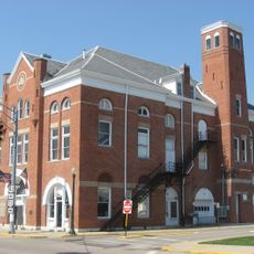
Greene County, County administration center in Xenia, United States.

Description

Greene County is an administrative region in southwestern Ohio with a county seat in Xenia. The area blends urban neighborhoods, rural farmland, and smaller towns across its territory.

History

The county was established in 1803 and named after General Nathanael Greene, a key military commander during the American Revolutionary War. This name honors his significant role in the nation's early military history.

Culture

The county administration organizes regular public meetings and community gatherings, fostering direct engagement between officials and residents throughout the year.

Practical

Visitors can access government services and obtain official documents at the county offices in Xenia during standard business hours. It's helpful to check ahead, as different departments may have varying schedules or closures.

Did you know?

The county operates an alert system that notifies residents about road conditions, water advisories, and emergency situations through multiple communication channels. This rapid notification network helps keep the community informed during critical events.

Location
Inception
May 1, 1803
Capital city
Xenia
Reference
GRE
Shares border with
Clark County, Clinton County, Madison County, Fayette County, Warren County, Montgomery County
GPS coordinates
39.69000,-83.89000
Latest update
December 19, 2025 23:45

AroundUs brings together thousands of curated places, local tips, and hidden gems, enriched daily by 60,000 contributors worldwide. Discover all places nearby (Ohio).

Around this place
National Museum of the United States Air Force
United States of America

National Museum of the United States Air Force

21.4 km
Bockscar
United States of America

Bockscar

21.4 km
United States of America

National Aviation Hall of Fame

21.3 km
Nutter Center
United States of America

Nutter Center

17.3 km
Dayton Aviation Heritage National Historical Park
United States of America

Dayton Aviation Heritage National Historical Park

20.6 km
Little Miami Scenic Trail
United States of America

Little Miami Scenic Trail

13 km
Huffman Prairie
United States of America

Huffman Prairie

19.6 km
John Bryan State Park
United States of America

John Bryan State Park

11.8 km
Glen Helen Nature Preserve
United States of America

Glen Helen Nature Preserve

12.1 km
Charles Young Buffalo Soldiers National Monument
United States of America

Charles Young Buffalo Soldiers National Monument

2.2 km
Whitelaw Reid House
United States of America

Whitelaw Reid House

8.3 km
United States of America

Indian Mound Reserve

8 km
Ohio Soldiers' and Sailors' Orphans' Home
United States of America

Ohio Soldiers' and Sailors' Orphans' Home

4.1 km
Kil-Kare Raceway
United States of America

Kil-Kare Raceway

7.4 km
Hindu Temple of Dayton
United States of America

Hindu Temple of Dayton

15.9 km
United States of America

National Afro-American Museum and Cultural Center

2.8 km
Clifton Gorge State Nature Preserve
United States of America

Clifton Gorge State Nature Preserve

11.7 km
Orators Mound
United States of America

Orators Mound

12.8 km
Wright-Patterson Air Force Base Mound
United States of America

Wright-Patterson Air Force Base Mound

19.8 km
Greene County Courthouse
United States of America

Greene County Courthouse

3.4 km
Fairborn Twin Cinemas
United States of America

Fairborn Twin Cinemas

18.6 km
Hollencamp House
United States of America

Hollencamp House

2.9 km
Yellow Springs Historic District
United States of America

Yellow Springs Historic District

12.6 km
McDonald Farm
United States of America

McDonald Farm

5.5 km
East Second Street Historic District
United States of America

East Second Street Historic District

3.1 km
Whitehall Farm
United States of America

Whitehall Farm

13.8 km
Cedarville Opera House
United States of America

Cedarville Opera House

9.2 km
Ballard Road Covered Bridge
United States of America

Ballard Road Covered Bridge

6.5 km
Show the full map
« Greene County - County administration center in Xenia, United States » is provided by Around Us (aroundus.com). Images and texts are derived from Wikimedia project under a Creative Commons license. You are allowed to copy, distribute, and modify copies of this page, under the conditions set by the license, as long as this note is clearly visible.

Discover hidden gems everywhere you go!

From secret cafés to breathtaking viewpoints, skip the crowded tourist spots and find places that match your style. Our app makes it easy with voice search, smart filtering, route optimization, and insider tips from travelers worldwide. Download now for the complete mobile experience.

Around Us App Screenshot

A unique approach to discovering new places

Le Figaro

All the places worth exploring

France Info

A tailor-made excursion in just a few clicks

20 Minutes

Around Us
Travel Guide & Maps
Download

Send to your phone

QR Code
1

Open the camera app on your mobile.

2

Point at the QR code with your camera. A notification will appear.

3

Tap the notification to open the link.