Chest opened
+${chestReward.xp} XP
Explorer
NOUVEAU ×${chestReward.collectible.quantity}
tapez pour fermer
Chest locked

Open chests in the app

Around Us is built for your phone — chests unlock when you walk, explore and capture nearby places.

Enable Location

We need your location to show you interesting places around you

Discover nearby places

Find interesting locations and hidden gems around you

Precise directions

Get accurate directions and distances to places

Your location is never shared with other users. It's only used when you tap the location button.

Log in to your account

Start exploring — it's free

Trusted by 72,996 travelers worldwide

Continue with Google
Continue with Apple
or

We will send you a code to connect

By continuing, you accept our Terms and Conditions and our Privacy Policy

Check your inbox

We've sent a pincode in your inbox. Please enter the code below.

Emergency Management Institute
Discussion Reviews Photo
9.3k Popularity

Emergency Management Institute, Federal emergency training campus in Emmitsburg, Maryland.

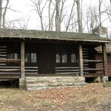
The Emergency Management Institute sits on a sprawling campus with classrooms and residential spaces designed to support comprehensive training in emergency response. The grounds include specialized training facilities where emergency professionals learn to handle different types of crises and disasters.

The facility started in 1951 as a civil defense training school in another location and relocated multiple times before establishing its current home. It grew over decades into a major training center for emergency management professionals across the nation.

The Civil Defense Monument on the grounds displays a granite pyramid topped with a bronze eagle, symbolizing the cooperation between government agencies in emergency response.

The institute runs many courses throughout the year for those working or studying in emergency response. Most training combines classroom instruction with hands-on exercises carried out on the campus grounds.

The campus houses a specialized laboratory where emergency managers train and test crisis response strategies through computer-based exercises. These virtual scenarios allow professionals to work through various emergency situations without putting anyone at risk.

The community of curious travelers

AroundUs brings together thousands of curated places, local tips, and hidden gems, enriched daily by 60,000 contributors worldwide.

Start exploring
Location
Inception
1951
GPS coordinates
39.69440,-77.32830
Latest update
December 10, 2025 15:58
Around this place
Eisenhower National Historic Site
United States of America

Eisenhower National Historic Site

12.3 km
Catoctin Mountain
United States of America

Catoctin Mountain

12.9 km
Sachs Covered Bridge
United States of America

Sachs Covered Bridge

12.3 km
National Shrine of St. Elizabeth Ann Seton
United States of America

National Shrine of St. Elizabeth Ann Seton

448 m
St. Joseph's College and Mother Seton Shrine
United States of America

St. Joseph's College and Mother Seton Shrine

548 m
National Fallen Firefighters Memorial
United States of America

National Fallen Firefighters Memorial

228 m
Camp Misty Mount Historic District
United States of America

Camp Misty Mount Historic District

11.8 km
Terra Rubra
United States of America

Terra Rubra

10.3 km
Fairfield Inn
United States of America

Fairfield Inn

10.3 km
LeGore Bridge
United States of America

LeGore Bridge

12.7 km
Roddy Road Covered Bridge
United States of America

Roddy Road Covered Bridge

8.2 km
Victor Cullen Center, Old Administration Building
United States of America

Victor Cullen Center, Old Administration Building

11.2 km
Alabama State Monument
United States of America

Alabama State Monument

12.1 km
Bullfrog Road Bridge
United States of America

Bullfrog Road Bridge

7.5 km
Jacks Mountain Covered Bridge
United States of America

Jacks Mountain Covered Bridge

9.5 km
Monterey Historic District
United States of America

Monterey Historic District

12.9 km
Fairfield Historic District
United States of America

Fairfield Historic District

11.6 km
Emmitsburg Historic District
United States of America

Emmitsburg Historic District

1.2 km
Graceham Moravian Church and Parsonage
United States of America

Graceham Moravian Church and Parsonage

9.7 km
Winemiller Family Farm
United States of America

Winemiller Family Farm

11.8 km
Fourpoints Bridge
United States of America

Fourpoints Bridge

3.5 km
Victor Cullen School Power House
United States of America

Victor Cullen School Power House

11.7 km
Bridge in Cumberland Township
United States of America

Bridge in Cumberland Township

7.9 km
Spangler-Benner Farm
United States of America

Spangler-Benner Farm

10.4 km
St. Euphemia's School and Sisters' House
United States of America

St. Euphemia's School and Sisters' House

1.2 km
Horner House and Barn
United States of America

Horner House and Barn

7.7 km
Catoctin Mountain Park Visitor Center
United States of America

Catoctin Mountain Park Visitor Center

12.4 km
Loys Station Covered Bridge
United States of America

Loys Station Covered Bridge

9.8 km
Show the full map
Reviews
Share your experience

No review yet

Discussions
Start a discussion...

No discussion yet

« Emergency Management Institute - Federal emergency training campus in Emmitsburg, Maryland » is provided by Around Us (aroundus.com). Images and texts are derived from Wikimedia project under a Creative Commons license. You are allowed to copy, distribute, and modify copies of this page, under the conditions set by the license, as long as this note is clearly visible.

Discover hidden gems everywhere you go!

From secret cafés to breathtaking viewpoints, skip the crowded tourist spots and find places that match your style. Our app makes it easy with voice search, smart filtering, route optimization, and insider tips from travelers worldwide. Download now for the complete mobile experience.

Around Us App Screenshot

A unique approach to discovering new places

Le Figaro

All the places worth exploring

France Info

A tailor-made excursion in just a few clicks

20 Minutes

Around Us
Travel Guide & Maps
Download

Send to your phone

QR Code
1

Open the camera app on your mobile.

2

Point at the QR code with your camera. A notification will appear.

3

Tap the notification to open the link.