Enable Location

We need your location to show you interesting places around you

Discover nearby places

Find interesting locations and hidden gems around you

Precise directions

Get accurate directions and distances to places

Your location is never shared with other users. It's only used when you tap the location button.

Log in to your account

Start exploring — it's free

Trusted by 64,020 travelers worldwide

Continue with Google
Continue with Apple
or

We will send you a code to connect

By continuing, you accept our Terms and Conditions and our Privacy Policy

Check your inbox

We've sent a pincode in your inbox. Please enter the code below.

Fort Watauga
Discussion Reviews Photo
6.6k Popularity

Fort Watauga, Colonial defensive fort in Elizabethton, Tennessee, US

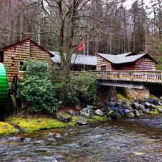
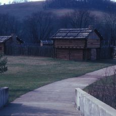
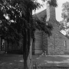
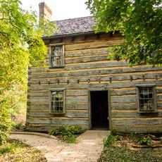
Fort Watauga is a reconstructed fortification along the Watauga River in Tennessee with wooden stockades and log structures typical of the 1770s. The site shows how settlers integrated their living spaces with defensive walls for protection.

The fort began in the 1770s as a settlement on disputed land and quickly became a military post. A major attack by Native American warriors in 1776 forced residents to defend themselves behind the walls.

The fort hosted early gatherings where settlers made decisions together, establishing practices different from eastern traditions of governance. These meetings show how frontier people created their own rules.

Visitors can walk through the reconstructed buildings to understand how daily life worked within the fort. It helps to allow time to explore the different areas and observe how the defensive layout functioned.

Excavations in the 1970s revealed the fort had an irregular shape rather than a typical rectangle. This unusual outline developed because residents incorporated existing cabins directly into the defensive walls.

The community of curious travelers

AroundUs brings together thousands of curated places, local tips, and hidden gems, enriched daily by 60,000 contributors worldwide.

Start exploring
Location
GPS coordinates
36.34410,-82.25420
Latest update
December 9, 2025 18:43
Around this place
Bristol Motor Speedway
United States of America

Bristol Motor Speedway

19.1 km
Watauga Lake
United States of America

Watauga Lake

22.6 km
United States of America

Gray Fossil Site

22.3 km
Sycamore Shoals
United States of America

Sycamore Shoals

231 m
Roan Mountain State Park
United States of America

Roan Mountain State Park

23.9 km
Overmountain Victory National Historic Trail
United States of America

Overmountain Victory National Historic Trail

3.9 km
South Holston Lake
United States of America

South Holston Lake

25 km
William B. Greene Jr. Stadium
United States of America

William B. Greene Jr. Stadium

11.9 km
Boone Lake
United States of America

Boone Lake

19.7 km
Sycamore Shoals State Historic Area
United States of America

Sycamore Shoals State Historic Area

191 m
Tipton-Haynes State Historic Site
United States of America

Tipton-Haynes State Historic Site

9.2 km
Rocky Mount, Tennessee
United States of America

Rocky Mount, Tennessee

10.1 km
Mountain Home National Cemetery
United States of America

Mountain Home National Cemetery

11.5 km
Elizabethton Covered Bridge
United States of America

Elizabethton Covered Bridge

3.8 km
Sabine Hill
United States of America

Sabine Hill

2.5 km
Jonesborough Historic District
United States of America

Jonesborough Historic District

20.5 km
Aquone
United States of America

Aquone

10.3 km
Sycamore Shoals State Historic Park
United States of America

Sycamore Shoals State Historic Park

150 m
Simerly-Butler House
United States of America

Simerly-Butler House

9.9 km
Shelbridge
United States of America

Shelbridge

10.1 km
John T. Wilder House
United States of America

John T. Wilder House

23.3 km
Holiday Lanes
United States of America

Holiday Lanes

10.7 km
Mountain Branch, National Home for Disabled Volunteer Soldiers
United States of America

Mountain Branch, National Home for Disabled Volunteer Soldiers

11.3 km
Thankful Baptist Church
United States of America

Thankful Baptist Church

9.1 km
Jonesborough United Methodist Church
United States of America

Jonesborough United Methodist Church

20.7 km
Henry Hoss House
United States of America

Henry Hoss House

19.3 km
Sulphur Springs Methodist Campground
United States of America

Sulphur Springs Methodist Campground

25.8 km
Shook Branch Swimming Area
United States of America

Shook Branch Swimming Area

12.2 km
Show the full map
Reviews
Share your experience

No review yet

Discussions
Start a discussion...

No discussion yet

« Fort Watauga - Colonial defensive fort in Elizabethton, Tennessee, US » is provided by Around Us (aroundus.com). Images and texts are derived from Wikimedia project under a Creative Commons license. You are allowed to copy, distribute, and modify copies of this page, under the conditions set by the license, as long as this note is clearly visible.

Discover hidden gems everywhere you go!

From secret cafés to breathtaking viewpoints, skip the crowded tourist spots and find places that match your style. Our app makes it easy with voice search, smart filtering, route optimization, and insider tips from travelers worldwide. Download now for the complete mobile experience.

Around Us App Screenshot

A unique approach to discovering new places

Le Figaro

All the places worth exploring

France Info

A tailor-made excursion in just a few clicks

20 Minutes

Around Us
Travel Guide & Maps
Download

Send to your phone

QR Code
1

Open the camera app on your mobile.

2

Point at the QR code with your camera. A notification will appear.

3

Tap the notification to open the link.