Chest opened
+${chestReward.xp} XP
Explorer
NOUVEAU ×${chestReward.collectible.quantity}
tapez pour fermer
Chest locked

Open chests in the app

Around Us is built for your phone — chests unlock when you walk, explore and capture nearby places.

Enable Location

We need your location to show you interesting places around you

Discover nearby places

Find interesting locations and hidden gems around you

Precise directions

Get accurate directions and distances to places

Your location is never shared with other users. It's only used when you tap the location button.

Log in to your account

Start exploring — it's free

Trusted by 72,971 travelers worldwide

Continue with Google
Continue with Apple
or

We will send you a code to connect

By continuing, you accept our Terms and Conditions and our Privacy Policy

Check your inbox

We've sent a pincode in your inbox. Please enter the code below.

Fort Stevenson
Discussion Reviews Photo
2.2k Popularity

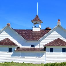
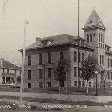
Fort Stevenson, Military fort near Garrison, North Dakota, United States.

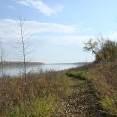
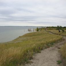
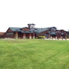
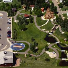
Fort Stevenson State Park sits on a peninsula jutting into Lake Sakakawea, covering a large area with multiple sections and facilities. The grounds feature hiking trails, two marinas with boat rentals and fish cleaning stations, plus recreational areas for water activities and camping.

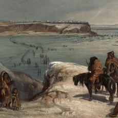
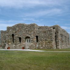
The military post was established in 1867 as a supply center for other military stations scattered across Dakota Territory. It was abandoned in 1883 when the Army's presence in the region was no longer needed.

The reconstructed guardhouse shows exhibits about soldier life and interaction with Mandan, Hidatsa, and Arikara communities. You can see how these groups lived and worked near each other during this period.

The park is easy to explore and works well for water activities and hiking during warm months when conditions are best. The marinas and fishing areas can get busy, so arriving early helps you find space and avoid crowds.

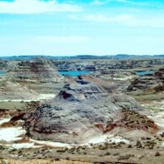
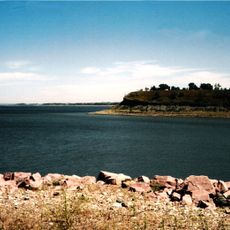
The original fort location now sits underwater beneath Lake Sakakawea, several miles southwest of where the park stands today. This happened when the reservoir was created in the mid-1900s.

The community of curious travelers

AroundUs brings together thousands of curated places, local tips, and hidden gems, enriched daily by 60,000 contributors worldwide.

Start exploring
Location
GPS coordinates
47.56720,-101.43100
Latest update
December 13, 2025 12:41
Around this place
Hell Creek Formation
United States of America

Hell Creek Formation

74.5 km
United States of America

Lake Sakakawea

7.8 km
Fort Mandan
United States of America

Fort Mandan

32.1 km
Scandinavian Heritage Park
United States of America

Scandinavian Heritage Park

74 km
Maysa Arena
United States of America

Maysa Arena

73 km
Audubon National Wildlife Refuge
United States of America

Audubon National Wildlife Refuge

19.5 km
Fort Clark Trading Post State Historic Site
United States of America

Fort Clark Trading Post State Historic Site

37 km
Lake Sakakawea State Park
United States of America

Lake Sakakawea State Park

5.1 km
Cross Ranch State Park
United States of America

Cross Ranch State Park

51 km
Fort Stevenson State Park
United States of America

Fort Stevenson State Park

2.8 km
North Dakota Lewis and Clark Interpretive Center
United States of America

North Dakota Lewis and Clark Interpretive Center

41.7 km
Fred Krause House
United States of America

Fred Krause House

33.8 km
Holy Trinity Ukrainian Greek Orthodox Church
United States of America

Holy Trinity Ukrainian Greek Orthodox Church

66.3 km
Lost Lake National Wildlife Refuge
United States of America

Lost Lake National Wildlife Refuge

52.7 km
Taube Museum of Art
United States of America

Taube Museum of Art

75.2 km
Liberty Baptist Church
United States of America

Liberty Baptist Church

75.1 km
Former McLean County Courthouse
United States of America

Former McLean County Courthouse

43.3 km
Sheridan County Courthouse
United States of America

Sheridan County Courthouse

75 km
Minot Carnegie Library
United States of America

Minot Carnegie Library

75 km
Bruce M. Van Sickle Federal Building and U.S. Courthouse
United States of America

Bruce M. Van Sickle Federal Building and U.S. Courthouse

75 km
United States of America

Ingersoll School

35.3 km
Alfred and Clara Sevareid House
United States of America

Alfred and Clara Sevareid House

66.5 km
Union National Bank and Annex
United States of America

Union National Bank and Annex

75.2 km
Wabek Consolidated School
United States of America

Wabek Consolidated School

59.5 km
McLean County Courthouse
United States of America

McLean County Courthouse

43.3 km
Ward County Courthouse
United States of America

Ward County Courthouse

74.9 km
Scandinavian Heritage Association
United States of America

Scandinavian Heritage Association

74 km
Paul Broste Rock Museum
United States of America

Paul Broste Rock Museum

68.3 km
Show the full map
Reviews
Share your experience

No review yet

Discussions
Start a discussion...

No discussion yet

« Fort Stevenson - Military fort near Garrison, North Dakota, United States » is provided by Around Us (aroundus.com). Images and texts are derived from Wikimedia project under a Creative Commons license. You are allowed to copy, distribute, and modify copies of this page, under the conditions set by the license, as long as this note is clearly visible.

Discover hidden gems everywhere you go!

From secret cafés to breathtaking viewpoints, skip the crowded tourist spots and find places that match your style. Our app makes it easy with voice search, smart filtering, route optimization, and insider tips from travelers worldwide. Download now for the complete mobile experience.

Around Us App Screenshot

A unique approach to discovering new places

Le Figaro

All the places worth exploring

France Info

A tailor-made excursion in just a few clicks

20 Minutes

Around Us
Travel Guide & Maps
Download

Send to your phone

QR Code
1

Open the camera app on your mobile.

2

Point at the QR code with your camera. A notification will appear.

3

Tap the notification to open the link.