Enable Location

We need your location to show you interesting places around you

Discover nearby places

Find interesting locations and hidden gems around you

Precise directions

Get accurate directions and distances to places

Your location is never shared with other users. It's only used when you tap the location button.

Fort Kearny

Log in to your account

Start exploring — it's free

Trusted by 62,826 travelers worldwide

Continue with Google
Continue with Apple
or

We will send you a code to connect

By continuing, you accept our Terms and Conditions and our Privacy Policy

Check your inbox

We've sent a pincode in your inbox. Please enter the code below.

Fort Kearny

Fort Kearny, Civil War fortification in Northwest Washington, D.C., United States.

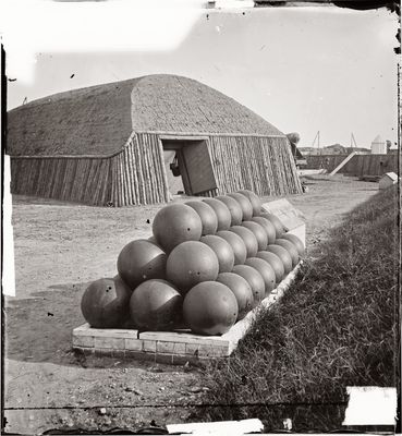
Fort Kearny was a Civil War fortification in Northwest Washington, D.C. that formed part of a larger defensive network protecting the capital's northern approaches. The installation featured multiple artillery batteries positioned to support the broader line of neighboring military works.

Construction of this fort began in 1862 by the 15th New Jersey Volunteer Infantry, who named it after General Philip Kearny following his death at Chantilly. The installation quickly became a key element in the defensive ring protecting Washington from northern approach routes.

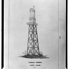
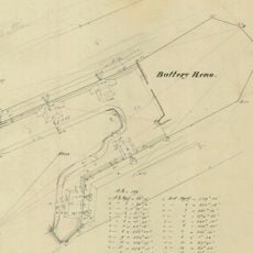
The fort integrated three supporting batteries - Battery Rossell, Battery Terrill, and Battery Smead - into its defense system north of the capital city.

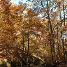
The fort is located within a residential neighborhood and is no longer visible as a distinct historical site since its original structures have disappeared. You can learn about its history through National Park Service materials and historical records that document the Civil War Defenses of Washington.

This installation featured advanced magazine facilities that set it apart from neighboring fortifications in the defensive ring. These specialized storage structures were crucial for maintaining sustained artillery fire and ammunition reserves during prolonged defensive operations.

The community of curious travelers

AroundUs brings together thousands of curated places, local tips, and hidden gems, enriched daily by 60,000 contributors worldwide.

Start exploring
Location
Inception
1862
Part of
Civil War defenses of Washington, D.C.
GPS coordinates
38.95525,-77.06610
Latest update
December 14, 2025 16:43
Around this place
Hillwood Estate, Museum & Gardens
United States of America

Hillwood Estate, Museum & Gardens

1.7 km
Fort Reno Park
United States of America

Fort Reno Park

1.1 km
Peter Muhlenberg Memorial
United States of America

Peter Muhlenberg Memorial

349 m
Twelve Monograms
United States of America

Twelve Monograms

1.7 km
Intelsat headquarters
United States of America

Intelsat headquarters

1.4 km
Sedgwick Gardens
United States of America

Sedgwick Gardens

1.9 km
Avalon Theatre
United States of America

Avalon Theatre

1.5 km
Harold and Sylvia Greenberg Theatre
United States of America

Harold and Sylvia Greenberg Theatre

1.7 km
Francis Griffith Newlands Memorial Fountain
United States of America

Francis Griffith Newlands Memorial Fountain

1.7 km
Jesse Reno School
United States of America

Jesse Reno School

1 km
Grant Road Historic District
United States of America

Grant Road Historic District

1.1 km
Dumblane
United States of America

Dumblane

1.7 km
Chevy Chase Arcade
United States of America

Chevy Chase Arcade

1.1 km
Tenley-Friendship Neighborhood Library
United States of America

Tenley-Friendship Neighborhood Library

1.5 km
Convent de Bon Secours
United States of America

Convent de Bon Secours

1.5 km
Eldbrooke United Methodist Church
United States of America

Eldbrooke United Methodist Church

1.5 km
Ponce de Leon Apartment Building
United States of America

Ponce de Leon Apartment Building

697 m
Ross Drive Bridge
United States of America

Ross Drive Bridge

1.8 km
Chevy Chase Neighborhood Library
United States of America

Chevy Chase Neighborhood Library

1.4 km
Building at 3901 Connecticut Ave., NW
United States of America

Building at 3901 Connecticut Ave., NW

1.8 km
Springland
United States of America

Springland

1.6 km
N. Webster Chappell House
United States of America

N. Webster Chappell House

1.6 km
Dopamine Land D.C.: A Multisensory Experience
United States of America

Dopamine Land D.C.: A Multisensory Experience

1.7 km
Rock Creek Park Nature Center and Planetarium
United States of America

Rock Creek Park Nature Center and Planetarium

1.4 km
Morris House
United States of America

Morris House

1.9 km
Fort Reno
United States of America

Fort Reno

1.4 km
Soapstone Valley Park
United States of America

Soapstone Valley Park

1.2 km
Battery Reno
United States of America

Battery Reno

989 m
Show the full map
« Fort Kearny - Civil War fortification in Northwest Washington, D.C., United States » is provided by Around Us (aroundus.com). Images and texts are derived from Wikimedia project under a Creative Commons license. You are allowed to copy, distribute, and modify copies of this page, under the conditions set by the license, as long as this note is clearly visible.

Discover hidden gems everywhere you go!

From secret cafés to breathtaking viewpoints, skip the crowded tourist spots and find places that match your style. Our app makes it easy with voice search, smart filtering, route optimization, and insider tips from travelers worldwide. Download now for the complete mobile experience.

Around Us App Screenshot

A unique approach to discovering new places

Le Figaro

All the places worth exploring

France Info

A tailor-made excursion in just a few clicks

20 Minutes

Around Us
Travel Guide & Maps
Download

Send to your phone

QR Code
1

Open the camera app on your mobile.

2

Point at the QR code with your camera. A notification will appear.

3

Tap the notification to open the link.