Enable Location

We need your location to show you interesting places around you

Discover nearby places

Find interesting locations and hidden gems around you

Precise directions

Get accurate directions and distances to places

Your location is never shared with other users. It's only used when you tap the location button.

Guánica Light

Log in to your account

Start exploring — it's free

Trusted by 63,225 travelers worldwide

Continue with Google
Continue with Apple
or

We will send you a code to connect

By continuing, you accept our Terms and Conditions and our Privacy Policy

Check your inbox

We've sent a pincode in your inbox. Please enter the code below.

Discussion Reviews 1 Photos
1.8k Popularity

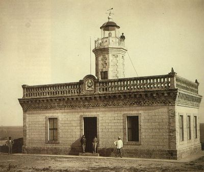
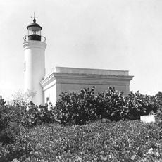
Guánica Light, Nineteenth century lighthouse ruins in Guánica, Puerto Rico.

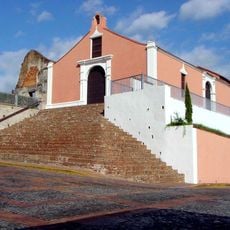
Guánica Light is an octagonal brick tower with a balcony and lantern that rises from a one-story building at the entrance to Guánica Bay. The structure now stands as ruins, though its distinctive shape and original stonework remain visible.

Built in the 19th century, this structure served as a crucial navigation point for ships entering Guánica Bay. In July 1898, lighthouse keeper Robustiano Rivera witnessed American forces landing during the Spanish-American War.

The entrance displays the official coat of arms of the Spanish Corps of Road Engineers, marking the colonial maritime heritage. This detail reveals how Spanish authorities managed coastal navigation and harbor operations.

The site can be accessed from PR-333 road, with parking available across the street for visitors. Wear sturdy shoes since the ground is uneven and the structure contains debris that requires careful exploration.

The structure was damaged by earthquakes in 1937 and 2020, resulting in significant structural deterioration. This seismic history illustrates how natural forces have shaped the building's condition over time.

The community of curious travelers

AroundUs brings together thousands of curated places, local tips, and hidden gems, enriched daily by 60,000 contributors worldwide.

Start exploring
Location
Location
GPS coordinates
17.95090,-66.90316
Latest update
December 14, 2025 11:42
Around this place
Porta Coeli
United States of America

Porta Coeli

21.1 km
Guánica State Forest
United States of America

Guánica State Forest

3 km
El Tuque
United States of America

El Tuque

24 km
Cementerio Civil de Ponce
Puerto Rico

Cementerio Civil de Ponce

29.4 km
Maricao State Forest
United States of America

Maricao State Forest

20.6 km
Cabo Rojo National Wildlife Refuge
United States of America

Cabo Rojo National Wildlife Refuge

28.3 km
Estadio Francisco Montaner
United States of America

Estadio Francisco Montaner

29.3 km
Parque del Retiro
United States of America

Parque del Retiro

30 km
San Isidro Labrador y Santa María de la Cabeza Church
United States of America

San Isidro Labrador y Santa María de la Cabeza Church

15.7 km
United States of America

Boquerón State Forest

23.5 km
San Vicente de Paul Catholic Cemetery
Puerto Rico

San Vicente de Paul Catholic Cemetery

29.4 km
Cardona Island Light
United States of America

Cardona Island Light

28.4 km
San Germán de Auxerre Church
United States of America

San Germán de Auxerre Church

21.1 km
United States of America

Monte Guilarte

25.6 km
McCabe Memorial Church
United States of America

McCabe Memorial Church

30.1 km
Logia Masónica Hijos de la Luz
United States of America

Logia Masónica Hijos de la Luz

10.9 km
Hacienda Santa Rita
United States of America

Hacienda Santa Rita

6.7 km
Monumento a los heroes de El Polvorín
United States of America

Monumento a los heroes de El Polvorín

29.4 km
Casa Franceschi Antongiorgi
United States of America

Casa Franceschi Antongiorgi

11 km
Daniel Webster School
United States of America

Daniel Webster School

22.4 km
Filardi House
United States of America

Filardi House

10.9 km
Chalet Amill
United States of America

Chalet Amill

11.2 km
Agostini House
United States of America

Agostini House

11 km
La Soplaera Waterfall
Puerto Rico

La Soplaera Waterfall

23.9 km
Salto Curet Waterfall
United States of America

Salto Curet Waterfall

24.4 km
Mangó Waterfall
Puerto Rico

Mangó Waterfall

26.8 km
Guilligan's Island
United States of America

Guilligan's Island

3.4 km
La Bahia Fosforescente
Puerto Rico

La Bahia Fosforescente

9.9 km
Show the full map
Reviews
Share your experience

No review yet

Discussions
Start a discussion...

No discussion yet

« Guánica Light - Nineteenth century lighthouse ruins in Guánica, Puerto Rico » is provided by Around Us (aroundus.com). Images and texts are derived from Wikimedia project under a Creative Commons license. You are allowed to copy, distribute, and modify copies of this page, under the conditions set by the license, as long as this note is clearly visible.

Discover hidden gems everywhere you go!

From secret cafés to breathtaking viewpoints, skip the crowded tourist spots and find places that match your style. Our app makes it easy with voice search, smart filtering, route optimization, and insider tips from travelers worldwide. Download now for the complete mobile experience.

Around Us App Screenshot

A unique approach to discovering new places

Le Figaro

All the places worth exploring

France Info

A tailor-made excursion in just a few clicks

20 Minutes

Around Us
Travel Guide & Maps
Download

Send to your phone

QR Code
1

Open the camera app on your mobile.

2

Point at the QR code with your camera. A notification will appear.

3

Tap the notification to open the link.