Chest opened
+${chestReward.xp} XP
Explorer
NOUVEAU ×${chestReward.collectible.quantity}
tapez pour fermer
Chest locked

Open chests in the app

Around Us is built for your phone — chests unlock when you walk, explore and capture nearby places.

Enable Location

We need your location to show you interesting places around you

Discover nearby places

Find interesting locations and hidden gems around you

Precise directions

Get accurate directions and distances to places

Your location is never shared with other users. It's only used when you tap the location button.

Log in to your account

Start exploring — it's free

Trusted by 72,988 travelers worldwide

Continue with Google
Continue with Apple
or

We will send you a code to connect

By continuing, you accept our Terms and Conditions and our Privacy Policy

Check your inbox

We've sent a pincode in your inbox. Please enter the code below.

Lake Isabella State Forest
Discussion Reviews Photo
1.4k Popularity

Lake Isabella State Forest, State forest in Lake County, Minnesota, US

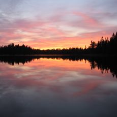
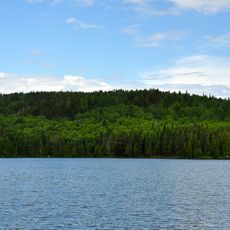
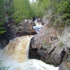
Lake Isabella State Forest is a wooded area covering 638 acres in Lake County, featuring dense forests, wetlands, and open spaces throughout. The property borders the Superior National Forest and contains hiking trails that wind through different landscape types.

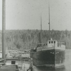
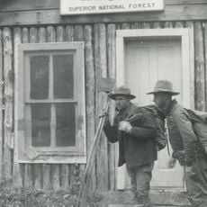
Early 1900s logging operations shaped the forest composition and became a dominant force in regional development and land management. These activities left lasting marks on how the forest regenerated and what grows there today.

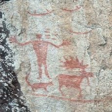
The forest lands hold connections to Native American tribes who first inhabited the region and utilized its natural resources for sustenance and ceremonies.

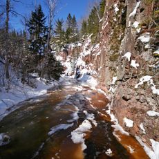
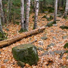
The forest offers hiking routes of varying difficulty, with amenities and services concentrated in the adjacent Superior National Forest area. It helps to bring maps and check conditions before visiting to understand where you can go.

At about 450 meters elevation, it ranks among the smallest forests in Minnesota's state system and often gets overlooked by visitors. Its small size means you can explore it quickly, yet its location next to larger wilderness areas makes it a useful gateway to the region.

The community of curious travelers

AroundUs brings together thousands of curated places, local tips, and hidden gems, enriched daily by 60,000 contributors worldwide.

Start exploring
Location
GPS coordinates
47.80960,-91.28620
Latest update
December 14, 2025 17:04
Around this place
Boundary Waters Canoe Area Wilderness
United States of America

Boundary Waters Canoe Area Wilderness

6.5 km
Eagle Mountain
United States of America

Eagle Mountain

55.1 km
Superior Hiking Trail
United States of America

Superior Hiking Trail

42.8 km
Palisade Head
United States of America

Palisade Head

54.8 km
Split Rock Lighthouse
United States of America

Split Rock Lighthouse

68.1 km
Quetico Provincial Park
Canada

Quetico Provincial Park

67.9 km
Tettegouche State Park
United States of America

Tettegouche State Park

53.1 km
Split Rock Lighthouse State Park
United States of America

Split Rock Lighthouse State Park

69.2 km
Temperance River State Park
United States of America

Temperance River State Park

42.1 km
Bear Head Lake State Park
United States of America

Bear Head Lake State Park

58.6 km
Cascade River State Park
United States of America

Cascade River State Park

58.2 km
Hegman Lake Pictograph
United States of America

Hegman Lake Pictograph

53.5 km
George H. Crosby Manitou State Park
United States of America

George H. Crosby Manitou State Park

39.1 km
Finland State Forest
United States of America

Finland State Forest

33.6 km
Amboy and George Spencer Shipwreck Sites
United States of America

Amboy and George Spencer Shipwreck Sites

42.7 km
Alex Seitaniemi Housebarn
United States of America

Alex Seitaniemi Housebarn

64.7 km
United States of America

North Shore Commercial Fishing Museum

42.9 km
Hartley Building
United States of America

Hartley Building

60.2 km
State Theater
United States of America

State Theater

44.3 km
Schroeder Lumber Company Bunkhouse
United States of America

Schroeder Lumber Company Bunkhouse

41.7 km
Longyear Drill Site
United States of America

Longyear Drill Site

68.3 km
Isabella Ranger Station
United States of America

Isabella Ranger Station

22.2 km
Waino Tanttari Field Hay Barn
United States of America

Waino Tanttari Field Hay Barn

66.5 km
Dorothy Molter Museum
United States of America

Dorothy Molter Museum

42.2 km
Cascade Lookout Tower
United States of America

Cascade Lookout Tower

52.9 km
Kekekabic Lookout Tower
United States of America

Kekekabic Lookout Tower

30.4 km
Finland Lookout Tower
United States of America

Finland Lookout Tower

39.5 km
Split Rock Lighthouse Overlook
United States of America

Split Rock Lighthouse Overlook

68.3 km
Show the full map
Reviews
Share your experience

No review yet

Discussions
Start a discussion...

No discussion yet

« Lake Isabella State Forest - State forest in Lake County, Minnesota, US » is provided by Around Us (aroundus.com). Images and texts are derived from Wikimedia project under a Creative Commons license. You are allowed to copy, distribute, and modify copies of this page, under the conditions set by the license, as long as this note is clearly visible.

Discover hidden gems everywhere you go!

From secret cafés to breathtaking viewpoints, skip the crowded tourist spots and find places that match your style. Our app makes it easy with voice search, smart filtering, route optimization, and insider tips from travelers worldwide. Download now for the complete mobile experience.

Around Us App Screenshot

A unique approach to discovering new places

Le Figaro

All the places worth exploring

France Info

A tailor-made excursion in just a few clicks

20 Minutes

Around Us
Travel Guide & Maps
Download

Send to your phone

QR Code
1

Open the camera app on your mobile.

2

Point at the QR code with your camera. A notification will appear.

3

Tap the notification to open the link.