Enable Location

We need your location to show you interesting places around you

Discover nearby places

Find interesting locations and hidden gems around you

Precise directions

Get accurate directions and distances to places

Your location is never shared with other users. It's only used when you tap the location button.

McCalls Ferry Farm

Log in to your account

Start exploring — it's free

Trusted by 62,371 travelers worldwide

Continue with Google
Continue with Apple
or

We will send you a code to connect

By continuing, you accept our Terms and Conditions and our Privacy Policy

Check your inbox

We've sent a pincode in your inbox. Please enter the code below.

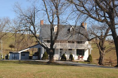
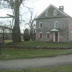
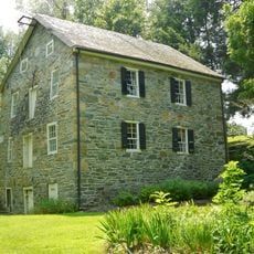
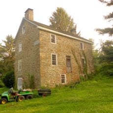
McCalls Ferry Farm, Historic farm complex in Lower Chanceford Township, Pennsylvania.

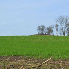
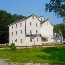
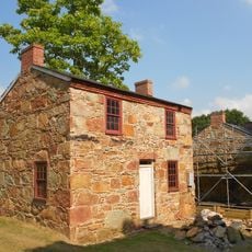
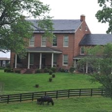
McCalls Ferry Farm is a historic farm complex in Lower Chanceford Township featuring structures from the late 18th century. The stone farmhouse with stucco finish is paired with a Sweitzer barn and frame corn barn that complete the working property.

The property was added to the National Register of Historic Places in 2000, documenting the area's farming heritage. The preserved structures demonstrate building techniques that were common in the region from the late 18th century forward.

The buildings show features of Pennsylvania German craftsmanship through their stone walls and traditional roof construction methods. These design choices reflect how early settlers in the region built their farms.

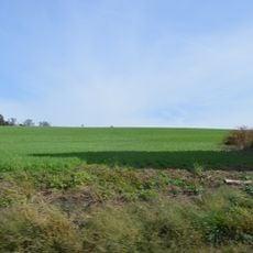
The property sits in a rural area east of Harrisburg and is accessible from Route 74. Visitors should contact in advance since this is an active farm operation rather than a public attraction open for regular visits.

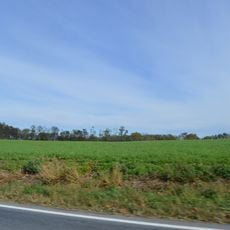
The Kilgore family operates a contemporary beef operation here, marketing their products online to customers across Virginia and southcentral Pennsylvania. This blend of historic structures and modern farming demonstrates how the land remains actively productive today.

The community of curious travelers

AroundUs brings together thousands of curated places, local tips, and hidden gems, enriched daily by 60,000 contributors worldwide.

Start exploring
Location
GPS coordinates
39.82500,-76.35610
Latest update
December 14, 2025 18:46
Around this place
Safe Harbor Dam
United States of America

Safe Harbor Dam

11.1 km
Hans Herr House
United States of America

Hans Herr House

19.1 km
Susquehannock State Park
United States of America

Susquehannock State Park

5.7 km
Conestoga Town
United States of America

Conestoga Town

15.5 km
Norman Wood Bridge
United States of America

Norman Wood Bridge

2.9 km
Baumgardener's Covered Bridge
United States of America

Baumgardener's Covered Bridge

12.9 km
Robert Fulton Birthplace
United States of America

Robert Fulton Birthplace

16.9 km
Safe Harbor Bridge
United States of America

Safe Harbor Bridge

11.4 km
Colemanville Covered Bridge
United States of America

Colemanville Covered Bridge

8.3 km
Lime Valley Covered Bridge
United States of America

Lime Valley Covered Bridge

18.3 km
Indian Steps Cabin
United States of America

Indian Steps Cabin

4.6 km
Muddy Creek Forks Historic District
United States of America

Muddy Creek Forks Historic District

10.4 km
Coulsontown Cottages Historic District
United States of America

Coulsontown Cottages Historic District

11.9 km
Duncan Island
United States of America

Duncan Island

4.1 km
Holtwood Environmental Preserve
United States of America

Holtwood Environmental Preserve

3.4 km
Delta Trestle Bridge, Maryland and Pennsylvania Railroad
United States of America

Delta Trestle Bridge, Maryland and Pennsylvania Railroad

10.9 km
Col. John Streett House
United States of America

Col. John Streett House

19.8 km
Wallace-Cross Mill
United States of America

Wallace-Cross Mill

16.1 km
Guinston United Presbyterian Church
United States of America

Guinston United Presbyterian Church

11.6 km
Strickler Site
United States of America

Strickler Site

19.4 km
Whiteford-Cardiff Historic District
United States of America

Whiteford-Cardiff Historic District

12.3 km
Mill Green Historic District
United States of America

Mill Green Historic District

18.1 km
Delta Historic District
United States of America

Delta Historic District

11.4 km
Murry Site
United States of America

Murry Site

19 km
Shultz-Funk Site
United States of America

Shultz-Funk Site

18.1 km
Payne's Folly
United States of America

Payne's Folly

16.7 km
1719 Museum
United States of America

1719 Museum

19.1 km
Kilgore Falls
United States of America

Kilgore Falls

15.9 km
Show the full map
« McCalls Ferry Farm - Historic farm complex in Lower Chanceford Township, Pennsylvania » is provided by Around Us (aroundus.com). Images and texts are derived from Wikimedia project under a Creative Commons license. You are allowed to copy, distribute, and modify copies of this page, under the conditions set by the license, as long as this note is clearly visible.

Discover hidden gems everywhere you go!

From secret cafés to breathtaking viewpoints, skip the crowded tourist spots and find places that match your style. Our app makes it easy with voice search, smart filtering, route optimization, and insider tips from travelers worldwide. Download now for the complete mobile experience.

Around Us App Screenshot

A unique approach to discovering new places

Le Figaro

All the places worth exploring

France Info

A tailor-made excursion in just a few clicks

20 Minutes

Around Us
Travel Guide & Maps
Download

Send to your phone

QR Code
1

Open the camera app on your mobile.

2

Point at the QR code with your camera. A notification will appear.

3

Tap the notification to open the link.