Enable Location

We need your location to show you interesting places around you

Discover nearby places

Find interesting locations and hidden gems around you

Precise directions

Get accurate directions and distances to places

Your location is never shared with other users. It's only used when you tap the location button.

Monongahela Cemetery

Log in to your account

Start exploring — it's free

Trusted by 62,842 travelers worldwide

Continue with Google
Continue with Apple
or

We will send you a code to connect

By continuing, you accept our Terms and Conditions and our Privacy Policy

Check your inbox

We've sent a pincode in your inbox. Please enter the code below.

Monongahela Cemetery, Friedhof in den Vereinigten Staaten

Monongahela Cemetery is a burial ground in Pennsylvania established in 1863 with extensive grounds covering rolling terrain. The site features paved pathways, open lawns, and a stone chapel at the summit, all designed by the landscape architects Hare & Hare.

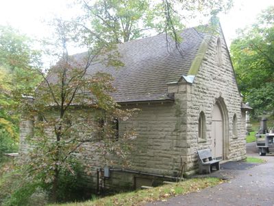
This cemetery was established in 1863 during the Civil War when the community needed a new burial ground. The first grave was interred in May of that year, and the stone chapel was constructed in 1894 by local architect F.P. Keller.

This cemetery was created by the community as a shared space for remembrance and honor. You can see how local families gathered together to establish a place that would hold the memory of those who had passed.

The paved pathways are easy to walk and gently slope upward toward the chapel at the top. The grounds are well maintained and accessible, allowing visitors to explore the lawns and tree-lined areas at a relaxed pace.

This cemetery is the only one in the country to be listed on the National Register of Historic Places specifically for its architecture and landscape design when it was added in 2001. This rare recognition highlights how thoughtful design by Hare & Hare created a place of national importance.

The community of curious travelers

AroundUs brings together thousands of curated places, local tips, and hidden gems, enriched daily by 60,000 contributors worldwide.

Start exploring
Location
Inception
1863
GPS coordinates
40.19417,-79.92222
Latest update
February 9, 2026 07:46
Around this place
Cement City Historic District
United States of America

Cement City Historic District

5.5 km
United States of America

Round Hill Park

9 km
Donora-Monessen Bridge
United States of America

Donora-Monessen Bridge

6.3 km
Edward G. Acheson House
United States of America

Edward G. Acheson House

1.5 km
Regis R. Malady Bridge
United States of America

Regis R. Malady Bridge

9.5 km
Donora-Webster Bridge
United States of America

Donora-Webster Bridge

6.1 km
Belle Vernon Bridge
United States of America

Belle Vernon Bridge

8.4 km
Ebenezer Covered Bridge
United States of America

Ebenezer Covered Bridge

10.1 km
Henry Covered Bridge
United States of America

Henry Covered Bridge

8.1 km
Van Kirk Farm
United States of America

Van Kirk Farm

7.3 km
Elizabeth Locks & Dam
United States of America

Elizabeth Locks & Dam

8.1 km
Speers Railroad Bridge
United States of America

Speers Railroad Bridge

8.3 km
Union Railroad Clairton Bridge
United States of America

Union Railroad Clairton Bridge

12.1 km
Charleroi-Monessen Bridge
United States of America

Charleroi-Monessen Bridge

5 km
Charleroi Locks & Dam
United States of America

Charleroi Locks & Dam

5.7 km
David Longwell House
United States of America

David Longwell House

1.5 km
Charleroi Historic District
United States of America

Charleroi Historic District

6.1 km
Enoch Wright House
United States of America

Enoch Wright House

11 km
Col. Edward Cook House
United States of America

Col. Edward Cook House

11 km
Hutchinson Farm (Elizabeth, Pennsylvania)
United States of America

Hutchinson Farm (Elizabeth, Pennsylvania)

7 km
Plumer House
United States of America

Plumer House

13.1 km
Bethel African American Episcopal Church of Monongahela City
United States of America

Bethel African American Episcopal Church of Monongahela City

1.7 km
Cerl Wright Covered Bridge
United States of America

Cerl Wright Covered Bridge

11.5 km
Bridge in Jefferson Borough
United States of America

Bridge in Jefferson Borough

11.7 km
Dusmal House
United States of America

Dusmal House

7.5 km
First National Bank of Charleroi
United States of America

First National Bank of Charleroi

6.6 km
Jefferson Hills Public Library
United States of America

Jefferson Hills Public Library

11.5 km
Family Funscape
United States of America

Family Funscape

6.8 km
Show the full map
« Monongahela Cemetery - Friedhof in den Vereinigten Staaten » is provided by Around Us (aroundus.com). Images and texts are derived from Wikimedia project under a Creative Commons license. You are allowed to copy, distribute, and modify copies of this page, under the conditions set by the license, as long as this note is clearly visible.

Discover hidden gems everywhere you go!

From secret cafés to breathtaking viewpoints, skip the crowded tourist spots and find places that match your style. Our app makes it easy with voice search, smart filtering, route optimization, and insider tips from travelers worldwide. Download now for the complete mobile experience.

Around Us App Screenshot

A unique approach to discovering new places

Le Figaro

All the places worth exploring

France Info

A tailor-made excursion in just a few clicks

20 Minutes

Around Us
Travel Guide & Maps
Download

Send to your phone

QR Code
1

Open the camera app on your mobile.

2

Point at the QR code with your camera. A notification will appear.

3

Tap the notification to open the link.