Enable Location

We need your location to show you interesting places around you

Discover nearby places

Find interesting locations and hidden gems around you

Precise directions

Get accurate directions and distances to places

Your location is never shared with other users. It's only used when you tap the location button.

Log in to your account

Start exploring — it's free

Trusted by 68,962 travelers worldwide

Continue with Google
Continue with Apple
or

We will send you a code to connect

By continuing, you accept our Terms and Conditions and our Privacy Policy

Check your inbox

We've sent a pincode in your inbox. Please enter the code below.

Naval Air Warfare Center, Indianapolis
Discussion Reviews Photo
1.7k Popularity

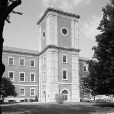
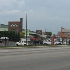
Naval Air Warfare Center, Indianapolis, Military research center in Warren Township, Indianapolis, US

The Naval Air Warfare Center in Indianapolis is an industrial facility dedicated to developing and testing advanced avionics systems for military aircraft. The installation houses specialized laboratories and test stands where engineers evaluate navigation, communication, and flight control technologies.

The facility started in 1942 as Naval Ordnance Plant, producing Norden Bombsights for precision bombing during World War II. After the war, it transitioned to aircraft technology work and closed in 1996 before being transferred to private management.

The facility received three Army-Navy E Awards between 1943 and 1945 for manufacturing excellence and maintained high technical standards throughout its operation.

The site is a research and development facility that is not open to general public visits since it operates as a military contractor location. Those with professional interest in defense technology can inquire through official channels.

The 1996 closure and transfer to Hughes Electronics marked the largest military facility privatization in United States history at that time.

The community of curious travelers

AroundUs brings together thousands of curated places, local tips, and hidden gems, enriched daily by 60,000 contributors worldwide.

Start exploring
Location
GPS coordinates
39.79450,-86.06020
Latest update
December 14, 2025 13:08
Around this place
Arsenal Technical High School
United States of America

Arsenal Technical High School

6.5 km
Benton House
United States of America

Benton House

3.5 km
Indianapolis Park and Boulevard System
United States of America

Indianapolis Park and Boulevard System

7.2 km
Morris-Butler House
United States of America

Morris-Butler House

7.6 km
Rivoli Theater
United States of America

Rivoli Theater

4.6 km
Brendonwood Historic District
United States of America

Brendonwood Historic District

7.4 km
Irvington Terrace Historic District
United States of America

Irvington Terrace Historic District

2.5 km
Tee Pee Restaurant
United States of America

Tee Pee Restaurant

7 km
William H. H. Graham House
United States of America

William H. H. Graham House

3.4 km
Bona Thompson Memorial Center
United States of America

Bona Thompson Memorial Center

3.4 km
Linwood Colonial Apartments
United States of America

Linwood Colonial Apartments

3.9 km
Horner–Terrill House
United States of America

Horner–Terrill House

4.1 km
Roy and Iris Corbin Lustron House
United States of America

Roy and Iris Corbin Lustron House

1.9 km
Spades Park Branch
United States of America

Spades Park Branch

6 km
Christian Park School No. 82
United States of America

Christian Park School No. 82

4.5 km
East Washington Branch
United States of America

East Washington Branch

5.6 km
Ralph Waldo Emerson Indianapolis Public School No. 58
United States of America

Ralph Waldo Emerson Indianapolis Public School No. 58

3.5 km
Prosser House
United States of America

Prosser House

6.4 km
Emerson Avenue Addition Historic District
United States of America

Emerson Avenue Addition Historic District

2.6 km
Carlos and Anne Recker House
United States of America

Carlos and Anne Recker House

2.6 km
John Fitch Hill House
United States of America

John Fitch Hill House

7 km
Thomas Askren House
United States of America

Thomas Askren House

578 m
The Gramse
United States of America

The Gramse

7.4 km
Julian-Clark House
United States of America

Julian-Clark House

3 km
State and Prospect District
United States of America

State and Prospect District

7.6 km
Immaculate Heart of Mary
United States of America

Immaculate Heart of Mary

6.8 km
John Greenleaf Whittier School, No. 33
United States of America

John Greenleaf Whittier School, No. 33

6 km
Gaseteria, Inc.
United States of America

Gaseteria, Inc.

7.5 km
Show the full map
Reviews
Share your experience

No review yet

Discussions
Start a discussion...

No discussion yet

« Naval Air Warfare Center, Indianapolis - Military research center in Warren Township, Indianapolis, US » is provided by Around Us (aroundus.com). Images and texts are derived from Wikimedia project under a Creative Commons license. You are allowed to copy, distribute, and modify copies of this page, under the conditions set by the license, as long as this note is clearly visible.

Discover hidden gems everywhere you go!

From secret cafés to breathtaking viewpoints, skip the crowded tourist spots and find places that match your style. Our app makes it easy with voice search, smart filtering, route optimization, and insider tips from travelers worldwide. Download now for the complete mobile experience.

Around Us App Screenshot

A unique approach to discovering new places

Le Figaro

All the places worth exploring

France Info

A tailor-made excursion in just a few clicks

20 Minutes

Around Us
Travel Guide & Maps
Download

Send to your phone

QR Code
1

Open the camera app on your mobile.

2

Point at the QR code with your camera. A notification will appear.

3

Tap the notification to open the link.